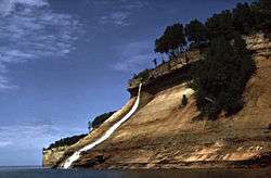
Bridalveil Falls (Michigan)
| Bridalveil Falls | |
|---|---|
 Bridalveil Falls, Michigan | |
 | |
| Location | Alger County, Michigan, United States |
| Coordinates | Maps 46°30′30″N 86°31′23″W / 46.50833°N 86.52306°WCoordinates: Maps 46°30′30″N 86°31′23″W / 46.50833°N 86.52306°W[1] |
| Type | Plunge Horsetail |
| Total height | 140 feet (43 m) |
Bridalveil Falls is a seasonal waterfall located at Pictured Rocks National Lakeshore, Michigan.[2] Directions: From H-58 from Munising go east 4.5 miles (7.2 km) to Miners Castle Road, then 5 miles (8.0 km) to the Castle. You can see this from afar from here. You can also see it from the Lake in a boat, or hiking on the Lakeshore Trail (Although only partial views from a distance can be seen from the trail itself. A dangerous view of the crest can be seen after a short hike from the trail.)[1]
References
- 1 2 http://www.easternwaterfalls.com/michigan.htm
- ↑ "Waterfalls - Pictured Rocks National Lakeshore". Nps.gov. Retrieved 2012-10-04.
This article is issued from
Wikipedia.
The text is licensed under Creative Commons - Attribution - Sharealike.
Additional terms may apply for the media files.