Schoolcraft County, Michigan
| Schoolcraft County, Michigan | |
|---|---|
 | |
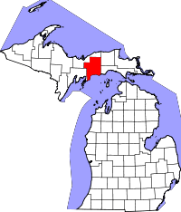 Location in the U.S. state of Michigan | |
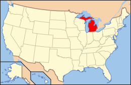 Michigan's location in the U.S. | |
| Founded |
9 March 1843 (created) 1876 (organized)[1][2] |
| Named for | Henry Schoolcraft |
| Seat | Manistique |
| Largest city | Manistique |
| Area | |
| • Total | 1,884 sq mi (4,880 km2) |
| • Land | 1,171 sq mi (3,033 km2) |
| • Water | 713 sq mi (1,847 km2), 38% |
| Population | |
| • (2010) | 8,485 |
| • Density | 7.2/sq mi (2.8/km2) |
| Congressional district | 1st |
| Time zone | Eastern |
Schoolcraft County is a county located in the Upper Peninsula of the U.S. state of Michigan. As of the 2010 United States Census, the population was 8,485.[3] The county seat is Manistique,[4] which lies along the northern shore of Lake Michigan. The county is named in honor of Henry Schoolcraft, who explored the area with the expedition of Lewis Cass.[1] The county was founded in 1843 and organized in 1876.[5] The county is largely rural and forested, with much of its western portion within Hiawatha National Forest.
Geography
According to the US Census Bureau, the county has a total area of 1,884 square miles (4,880 km2), of which 1,171 square miles (3,030 km2) is land and 713 square miles (1,850 km2) (38%) is water.[6]
Major highways


Airport
- Schoolcraft County Airport (IATA: ISQ, ICAO: ISQ, FAA LID: KISQ) - 3 miles NE of Manistique. County-owned public-use (general aviation). Two paved runways.
Adjacent counties
- Luce County – northeast
- Mackinac County – southeast
- Delta County – southwest
- Alger County - northwest and north
National protected areas
Demographics
| Historical population | |||
|---|---|---|---|
| Census | Pop. | %± | |
| 1880 | 1,575 | — | |
| 1890 | 5,818 | 269.4% | |
| 1900 | 7,889 | 35.6% | |
| 1910 | 8,681 | 10.0% | |
| 1920 | 9,977 | 14.9% | |
| 1930 | 8,451 | −15.3% | |
| 1940 | 9,524 | 12.7% | |
| 1950 | 9,148 | −3.9% | |
| 1960 | 8,953 | −2.1% | |
| 1970 | 8,226 | −8.1% | |
| 1980 | 8,575 | 4.2% | |
| 1990 | 8,302 | −3.2% | |
| 2000 | 8,903 | 7.2% | |
| 2010 | 8,485 | −4.7% | |
| Est. 2016 | 8,001 | [7] | −5.7% |
| US Decennial Census[8] 1790-1960[9] 1900-1990[10] 1990-2000[11] 2010-2013[3] | |||
The 2010 United States Census[12] indicates Schoolcraft County had a population of 8,485. This decrease of 418 people from the 2000 United States Census represents a -4.7% change in population. In 2010 there were 3,759 households and 2,425 families in the county. The population density was 7 people per square mile (3/km²). There were 6,313 housing units at an average density of 5 per square mile (2/km²). 87.6% of the population were White, 8.8% Native American, 0.2% Asian, 0.1% Black or African American, 0.1% of some other race and 3.3% of two or more races. 0.8% were Hispanic or Latino (of any race). 16.2% were of German, 13.2% French, French Canadian or Cajun, 7.8% Swedish, 6.7% Irish, 5.3% Polish, 5.2% English and 5.1% American ancestry.[13]
There were 3,759 households out of which 22.2% had children under the age of 18 living with them, 51.9% were married couples living together, 8.1% had a female householder with no husband present, and 35.5% were non-families. 30.9% of all households were made up of individuals and 14.7% had someone living alone who was 65 years of age or older. The average household size was 2.22 and the average family size was 2.72.
The county population contained 19.9% under the age of 18, 6.0% from 18 to 24, 19.6% from 25 to 44, 33.3% from 45 to 64, and 21.3% who were 65 years of age or older. The median age was 48.3 years. The population was 49.5% male and 50.5% female.
The median income for a household in the county was $38,367, and the median income for a family was $49,561. The per capita income for the county was $21,134. About 11.7% of families and 15.1% of the population were below the poverty line, including 20.3% of those under age 18 and 9.2% of those age 65 or over.
Government
Schoolcraft County has been Republican-leaning from its start. Since 1876, the Republican Party nominee has carried the county vote in 69% of the elections (25 of 36 elections).
| Year | Republican | Democratic | Third Parties |
|---|---|---|---|
| 2016 | 61.2% 2,556 | 32.8% 1,369 | 6.0% 252 |
| 2012 | 52.8% 2,142 | 45.9% 1,865 | 1.3% 54 |
| 2008 | 47.5% 2,058 | 50.4% 2,184 | 2.2% 93 |
| 2004 | 51.1% 2,267 | 48.1% 2,137 | 0.8% 37 |
| 2000 | 49.7% 2,088 | 48.5% 2,036 | 1.8% 74 |
| 1996 | 31.0% 1,200 | 56.5% 2,187 | 12.5% 484 |
| 1992 | 30.4% 1,253 | 51.8% 2,139 | 17.9% 737 |
| 1988 | 46.4% 1,802 | 53.3% 2,071 | 0.3% 13 |
| 1984 | 52.5% 2,139 | 47.1% 1,920 | 0.4% 18 |
| 1980 | 47.9% 2,097 | 44.9% 1,964 | 7.2% 313 |
| 1976 | 46.5% 1,933 | 52.0% 2,158 | 1.5% 63 |
| 1972 | 56.0% 2,310 | 42.7% 1,759 | 1.3% 55 |
| 1968 | 45.4% 1,745 | 48.6% 1,869 | 6.0% 230 |
| 1964 | 34.3% 1,397 | 65.6% 2,675 | 0.1% 4 |
| 1960 | 50.8% 2,183 | 49.0% 2,107 | 0.2% 8 |
| 1956 | 58.7% 2,453 | 41.3% 1,723 | 0.0% 1 |
| 1952 | 58.1% 2,352 | 41.8% 1,692 | 0.2% 8 |
| 1948 | 49.7% 1,713 | 47.9% 1,651 | 2.4% 83 |
| 1944 | 49.4% 1,704 | 50.0% 1,724 | 0.6% 19 |
| 1940 | 46.2% 2,003 | 53.5% 2,320 | 0.3% 11 |
| 1936 | 36.8% 1,430 | 60.1% 2,333 | 3.1% 122 |
| 1932 | 49.1% 1,722 | 47.3% 1,660 | 3.7% 129 |
| 1928 | 66.8% 1,826 | 32.1% 877 | 1.1% 30 |
| 1924 | 61.3% 1,515 | 7.7% 190 | 31.0% 765 |
| 1920 | 71.3% 1,776 | 17.2% 428 | 11.5% 286 |
| 1916 | 59.0% 994 | 37.0% 623 | 4.1% 69 |
| 1912 | 38.0% 595 | 21.5% 337 | 40.6% 636[15] |
| 1908 | 79.4% 1,360 | 16.9% 289 | 3.7% 63 |
| 1904 | 83.5% 1,472 | 12.8% 225 | 3.7% 66 |
| 1900 | 69.9% 1,141 | 28.2% 460 | 1.9% 31 |
| 1896 | 62.9% 973 | 35.4% 548 | 1.7% 27 |
| 1892 | 41.8% 570 | 47.7% 650 | 10.6% 144 |
| 1888 | 47.8% 590 | 47.7% 589 | 4.5% 55 |
| 1884 | 62.5% 518 | 34.9% 289 | 2.7% 22 |
| 1880 | 79.3% 157 | 20.7% 41 | 0.0% 0 |
| 1876 | 52.8% 121 | 45.0% 103 | 2.2% 5 |

Schoolcraft County operates the County jail, Schoolcraft County Public Transit, maintains rural roads, operates the major local courts, records deeds, mortgages, and vital records, administers public health regulations, and participates with the state in the provision of social services. The county board of commissioners controls the budget and has limited authority to make laws or ordinances. In Michigan, most local government functions — police and fire, building and zoning, tax assessment, street maintenance, etc. — are the responsibility of individual cities and townships.
Communities
City
- Manistique (county seat)
Unincorporated communities
Townships
Historic places
The National Register of Historic Places listings in Schoolcraft County, Michigan are:
- Ten Curves Road – Manistique River Bridge – Ten Curves Rd. over Manistique River in Gemfask Township (added 17 December 1999)
- Manistique East Breakwater Light – at offshore end of east breakwater, approx. 1,800 ft. from shore (added 6 September 2005)
- Manistique Pumping Station – on Deer St. (added 26 October 1981)
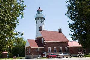
- Seul Choix Pointe Light Station – County Rd. 431 in Manistique (added 17 July 1984)
- Ekdahl-Goudreau Site – west of Seul Choix Point (added 16 November 1978).
See also
References
- 1 2 "Bibliography on Schoolcraft County". Clarke Historical Library, Central Michigan University. Retrieved 29 January 2013.
- ↑ "History :: Houghton County, Michigan". houghtoncounty.net. Archived from the original on 21 January 2011.
- 1 2 "State & County QuickFacts". US Census Bureau. Retrieved 29 August 2013.
- ↑ "Find a County". National Association of Counties. Retrieved 7 June 2011.
- ↑ "Schoolcraft County – Early 1880s". cityofmanistique.org. Schoolcraft County Historical Society. Retrieved 4 October 2014.
- ↑ "2010 Census Gazetteer Files". US Census Bureau. 22 August 2012. Retrieved 28 September 2014.
- ↑ "Population and Housing Unit Estimates". Retrieved 9 June 2017.
- ↑ "US Decennial Census". US Census Bureau. Retrieved 28 September 2014.
- ↑ "Historical Census Browser". University of Virginia Library. Retrieved 28 September 2014.
- ↑ "Population of Counties by Decennial Census: 1900 to 1990". US Census Bureau. Retrieved 28 September 2014.
- ↑ "Census 2000 PHC-T-4. Ranking Tables for Counties: 1990 and 2000" (PDF). US Census Bureau. Retrieved 28 September 2014.
- ↑ "Census 2010 American Fact Finder". Retrieved 17 July 2013.
- ↑ Data Access and Dissemination Systems (DADS). "American FactFinder". census.gov.
- ↑ US Election Atlas
- ↑ The leading "other" candidate, Progressive Theodore Roosevelt, received 570 votes, while Socialist candidate Eugene Debs received 49 votes, Prohibition candidate Eugene Chafin received 14 votes, and Socialist Labor candidate Arthur Reimer received 3 votes.
External links
- Schoolcraft County website
- Schoolcraft County Profile, Sam M Cohodas Regional Economist
- "Bibliography on Schoolcraft County". Clarke Historical Library, Central Michigan University.
Places adjacent to Schoolcraft County, Michigan | ||||||||||
|---|---|---|---|---|---|---|---|---|---|---|
| ||||||||||
Municipalities and communities of Schoolcraft County, Michigan, United States | ||
|---|---|---|
| City | | |
| Townships | ||
| Unincorporated communities | ||
| Central cities | |
|---|---|
| Counties | |
| Geography | |
| Transportation | |
| Economy | |