Meridian-Baseline State Park
| Meridian-Baseline State Park | |
|---|---|
 Location in Michigan | |
| Location |
Ingham County, Michigan and Jackson County, Michigan |
| Nearest city | Leslie, Michigan |
| Coordinates | 42°25′26″N 84°21′49″W / 42.42393°N 84.36368°WCoordinates: 42°25′26″N 84°21′49″W / 42.42393°N 84.36368°W |
| Area | 108 acres (44 ha) |
| Established | 1960s |
| Governing body | Michigan Department of Natural Resources |
| Website | Meridian-Baseline State Park |
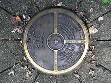
Meridian-Baseline State Park is a 108-acre (44 ha) state park in Ingham County and Jackson County, Michigan, that contains the intersection of the Michigan meridian and the baseline used for the Michigan Survey.[1] The park has two monuments that show where the two mismatched baselines meet the principal meridian at the North Initial Point and South Initial Point.[2][3]
Park history

Efforts to acquire the site were initiated by state and private interests in the 1960s. In the 1960s and 1970s, land was acquired and money was raised toward establishing a Museum of Surveying on the site. Those efforts were abandoned when the Michigan Society of Professional Surveyors opened a museum in Lansing, Michigan, in 1981.[4]
Although the site was landlocked for many years, in 2014, the Michigan Department of Natural Resources acquired additional property allowing public access from Meridian Road near the Jackson-Ingham county line.[5] Improvements made at the site included trail clearing and construction of a 10-car parking lot.[6] After road signs, trail markers, and a bridge over the creek were added, the State of Michigan in conjunction with Ingham and Jackson counties, opened the new access to the park on October 12, 2015. In 2016, an additional boardwalk was completed in the wetlands near the markers.[6]
References
- ↑ "Meridian-Baseline State Park". Michigan Department of Natural Resources. Retrieved March 10, 2018.
This unique park designates the spot where all township, range and section measurements begin for the entire state of Michigan. It is being preserved for its historic value. It is approximately a one and a half mile round trip hike to view the monuments. Parking is located off Meridian Road at the trailhead. There is currently no water or restroom facilities.
- ↑ "Michigan Meridian". The Center for Land Use Interpretation. Retrieved October 7, 2012.
- ↑ Kurt A. Luebke (October 6, 2006). "Michigan Meridian". Principal Meridian Project. Retrieved October 7, 2012.
- ↑ Wyatt, Ken (December 31, 2010). "Meridian-Baseline site is indeed special". Jackson Citizen Patriot. Retrieved January 13, 2012.
- ↑ Brad Flory (January 7, 2015). "Remembering what happened in Jackson County 200 years ago". MLive.
- 1 2 "Surveying Michigan 200th Anniversary". 1815 Surveying Michigan. October 11, 2015.
Externail links
- Meridian-Baseline State Park Michigan Department of Natural Resources
- Meridian-Baseline State Park Map Michigan Department of Natural Resources
- Meridian-Baseline State Park Topo Map Michigan Department of Natural Resources