Hancock, Michigan
| Hancock, Michigan | |
|---|---|
| City | |
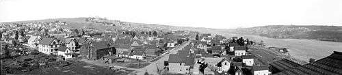
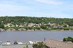 Hancock from Houghton | |
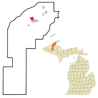 Location of Hancock, Michigan | |
| Coordinates: 47°7′49″N 88°35′47″W / 47.13028°N 88.59639°W | |
| Country | United States |
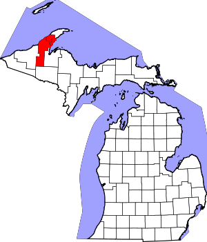
| State | Michigan |
| County | Houghton |
| Area[1] | |
| • Total | 2.97 sq mi (7.69 km2) |
| • Land | 2.60 sq mi (6.73 km2) |
| • Water | 0.37 sq mi (0.96 km2) |
| Elevation | 696 ft (212 m) |
| Population (2010)[2] | |
| • Total | 4,634 |
| • Estimate (2016)[3] | 4,586 |
| • Density | 1,600/sq mi (600/km2) |
| Time zone | UTC-5 (EST (UTC-5)) |
| • Summer (DST) | UTC-4 (EDT (UTC-4)) |
| ZIP code | 49930 |
| Area code(s) | 906 |
| FIPS code | 26-36300[4] |
| GNIS feature ID | 0627710[5] |
| Website |
www |
Hancock is a city in Houghton County, Michigan, United States and is located on Copper Island, which is part of the Keweenaw Peninsula, on the Keweenaw Waterway directly opposite Houghton, Michigan. The population was 4,634 at the 2010 census.
History
The land on which Hancock was built was originally owned by James Hicks.[6]
The earliest building in what is now the City of Hancock was a log cabin erected in 1846 on the site of the Ruggles Mining Claim; it is no longer standing, the site taken up by the Houghton County Garage buildings.[7] It was owned by Christopher Columbus (C.C.) Douglass, who came to live there in 1852. The Quincy Mining Company founded Hancock in 1859 after purchasing land from Douglass and building an office and mine on the site.[8] The city was named after John Hancock, signer of the Declaration of Independence.[9]
Hancock's first store was built by the Leopold brothers in 1858; the store also housed the first post office. Samuel W. Hill, an agent for the Quincy Mining Company, platted Hancock Village in 1859. Although it was organized and officers elected in 1863, the village was not incorporated until 1875[7] under a charter amended in 1877.[10]
In 1860, the Portage Lake smelter opened in Hancock.
In 1869 a fire burnt down about 75% of the village. There was also a significant fire in the 1940s that destroyed much of the downtown.[11]
The Mineral Range Railroad began providing passenger and freight service between Hancock and Calumet in 1873.[12]
Hancock was incorporated as a city in 1903.[13]
Geography
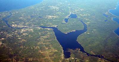
According to the United States Census Bureau, the city has a total area of 2.97 square miles (7.69 km2), of which 2.60 square miles (6.73 km2) is land and 0.37 square miles (0.96 km2) is water.[1] Hancock is connected to Houghton, Michigan by the Portage Lake Lift Bridge, which crosses the dredged Keweenaw Waterway.
The city is bounded on the south by the Portage Canal, parts of Quincy, Hancock and Franklin Townships; on the east by West Ripley; and on the north by Quincy and Hancock Townships.
Climate
Hancock has a humid continental climate, with typically long and snowy winters and much lake effect snow. Hancock has the distinction of being the second snowiest city in the United States (and the snowiest city in the East) with snowfall averaging 211.7 inches per year. The city is located along the lake effect snow-prone Keweenaw Peninsula. In the 1978–79 snow season, a whopping 390 inches of snow fell in Hancock. Accumulating snow has been known to fall as late as early June here.[14]
| Climate data for Hancock, Michigan (Houghton County Memorial Airport), 1981–2010 normals | |||||||||||||
|---|---|---|---|---|---|---|---|---|---|---|---|---|---|
| Month | Jan | Feb | Mar | Apr | May | Jun | Jul | Aug | Sep | Oct | Nov | Dec | Year |
| Record high °F (°C) | 50 (10) |
60 (16) |
79 (26) |
88 (31) |
95 (35) |
99 (37) |
102 (39) |
98 (37) |
95 (35) |
86 (30) |
71 (22) |
64 (18) |
102 (39) |
| Average high °F (°C) | 22.1 (−5.5) |
24.6 (−4.1) |
33.5 (0.8) |
46.9 (8.3) |
61.0 (16.1) |
70.2 (21.2) |
75.3 (24.1) |
73.9 (23.3) |
64.6 (18.1) |
51.2 (10.7) |
37.6 (3.1) |
26.2 (−3.2) |
49.0 (9.4) |
| Daily mean °F (°C) | 15.5 (−9.2) |
16.9 (−8.4) |
25.2 (−3.8) |
38.0 (3.3) |
50.2 (10.1) |
59.3 (15.2) |
64.8 (18.2) |
63.9 (17.7) |
55.4 (13) |
43.4 (6.3) |
31.4 (−0.3) |
20.2 (−6.6) |
40.5 (4.7) |
| Average low °F (°C) | 8.8 (−12.9) |
9.1 (−12.7) |
16.8 (−8.4) |
29.0 (−1.7) |
39.4 (4.1) |
48.4 (9.1) |
54.2 (12.3) |
54.0 (12.2) |
46.3 (7.9) |
35.6 (2) |
25.3 (−3.7) |
14.2 (−9.9) |
31.9 (−0.1) |
| Record low °F (°C) | −29 (−34) |
−30 (−34) |
−23 (−31) |
−4 (−20) |
19 (−7) |
28 (−2) |
32 (0) |
34 (1) |
24 (−4) |
12 (−11) |
−7 (−22) |
−19 (−28) |
−30 (−34) |
| Average precipitation inches (mm) | 2.58 (65.5) |
1.37 (34.8) |
1.56 (39.6) |
1.84 (46.7) |
2.50 (63.5) |
2.58 (65.5) |
2.49 (63.2) |
2.41 (61.2) |
3.45 (87.6) |
2.99 (75.9) |
2.13 (54.1) |
1.89 (48) |
27.79 (705.9) |
| Average snowfall inches (cm) | 68.8 (174.8) |
30.9 (78.5) |
19.2 (48.8) |
7.8 (19.8) |
1.0 (2.5) |
0.0 (0) |
0.0 (0) |
0.0 (0) |
0.2 (0.5) |
4.7 (11.9) |
22.2 (56.4) |
52.9 (134.4) |
207.7 (527.6) |
| Average precipitation days (≥ 0.01 in) | 17.4 | 12.3 | 11.5 | 10.0 | 11.1 | 10.7 | 10.8 | 9.4 | 13.5 | 15.2 | 14.9 | 15.1 | 151.9 |
| Average snowy days (≥ 0.1 in) | 23.2 | 15.5 | 10.3 | 4.9 | 0.8 | 0.0 | 0.0 | 0.0 | 0.2 | 3.5 | 12.4 | 19.7 | 90.5 |
| Source: NOAA (extremes 1887–present)[15][16] | |||||||||||||
People and culture
Hancock has been called "the focal point of Finns in the United States".[17] Hancock hosts an annual midwinter festival called Heikinpäivä, celebrating the feast day of Saint Henrik, patron saint of Finland,[9] and Heikki Lunta.
Every summer, the cities of Hancock and neighboring Houghton host a festival known as "Bridgefest," to commemorate the building of the Portage Lake Lift Bridge.[9]
Demographics
| Historical population | |||
|---|---|---|---|
| Census | Pop. | %± | |
| 1880 | 1,783 | — | |
| 1890 | 1,772 | −0.6% | |
| 1900 | 4,050 | 128.6% | |
| 1910 | 8,981 | 121.8% | |
| 1920 | 7,527 | −16.2% | |
| 1930 | 5,795 | −23.0% | |
| 1940 | 5,554 | −4.2% | |
| 1950 | 5,223 | −6.0% | |
| 1960 | 5,022 | −3.8% | |
| 1970 | 4,820 | −4.0% | |
| 1980 | 5,122 | 6.3% | |
| 1990 | 4,547 | −11.2% | |
| 2000 | 4,323 | −4.9% | |
| 2010 | 4,634 | 7.2% | |
| Est. 2016 | 4,586 | [3] | −1.0% |
| U.S. Decennial Census[18] | |||

2010 census
As of the census[2] of 2010, there were 4,634 people, 1,882 households, and 934 families residing in the city. The population density was 1,782.3 inhabitants per square mile (688.1/km2). There were 2,111 housing units at an average density of 811.9 per square mile (313.5/km2). The racial makeup of the city was 94.7% White, 1.2% African American, 1.0% Native American, 1.7% Asian, 0.1% Pacific Islander, 0.1% from other races, and 1.3% from two or more races. Hispanic or Latino of any race were 1.4% of the population.
There were 1,882 households of which 21.4% had children under the age of 18 living with them, 36.4% were married couples living together, 9.7% had a female householder with no husband present, 3.6% had a male householder with no wife present, and 50.4% were non-families. 37.7% of all households were made up of individuals and 13% had someone living alone who was 65 years of age or older. The average household size was 2.20 and the average family size was 2.90.
The median age in the city was 34.1 years. 16.7% of residents were under the age of 18; 21.8% were between the ages of 18 and 24; 20.8% were from 25 to 44; 21.5% were from 45 to 64; and 19.3% were 65 years of age or older. The gender makeup of the city was 49.5% male and 50.5% female.
2000 census
As of the census[4] of 2000, there were 4,323 people, 1,769 households, and 902 families residing in the city. The population density was 1,727.5 inhabitants per square mile (667.0/km2). There were 1,983 housing units at an average density of 792.4 per square mile (305.9/km2). The racial makeup of the city was 96.0% White, 0.8% Black or African American, 0.9% Native American, 1.1% Asian, <0.1% Pacific Islander, 0.2% from other races, and 1.0% from two or more races. 0.8% of the population were Hispanic or Latino of any race. 32.2% were of Finnish, 14.4% German, 8.2% English, 5.3% Italian, and 5.2% French ancestry according to Census 2000. 94.4% spoke English and 4.4% Finnish as their first language.
There were 1,769 households out of which 23.3% had children under the age of 18 living with them, 39.2% were married couples living together, 9.2% had a female householder with no husband present, and 49.0% were non-families. 38.8% of all households were made up of individuals and 14.9% had someone living alone who was 65 years of age or older. The average household size was 2.22 and the average family size was 2.97.
In the city, the population was spread out with 19.0% under the age of 18, 18.0% from 18 to 24, 22.6% from 25 to 44, 20.1% from 45 to 64, and 20.3% who were 65 years of age or older. The median age was 37 years. For every 100 females, there were 98.6 males. For every 100 females age 18 and over, there were 97.1 males.
The median income for a household in the city was $28,118, and the median income for a family was $36,625. Males had a median income of $27,090 versus $22,150 for females. The per capita income for the city was $16,669. About 6.9% of families and 14.4% of the population were below the poverty line, including 7.0% of those under age 18 and 15.1% of those age 65 or over.
Neighborhoods
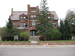
The East Hancock neighborhood is part of the city and consists of many old Victorian-style houses which were once owned by mining company officials.
Doctors' Park, located in West Hancock near the former Portage View Hospital Building (now the Portage Campus of Finlandia University). It lies north of West Quincy Street.
The Quincy Street Historic District encompasses the center of Hancock's downtown, covering the 100, 200, and 300 blocks of Quincy Street.
UP Health system operates a Hospital with a Level 3 Trauma Center at 500 Campus Drive Hancock, MI 49930 called UP Health System - Portage.
Arts and culture
Museums and galleries
The birthplace of Mary Chase Perry Stratton, founder of Pewabic Pottery, "escaped the 1869 fire"; it is now called Pewabic House and run as a museum.[19]
The Kerredge Gallery and the Republic Bank Gallery are both located inside the Copper Country Community Arts Center.[20]
Turquoise Art Gallery is also located in Hancock.[21]
Sports
The 2004 Professional Walleye Trail Championship Tournament was held partly in the city.[9]
Parks and recreation
Bicycling
The Jack Stevens Trail runs through the city.[22]
Education
Public education
Elementary-school students attend the Gordon Barkell Elementary School (formerly Hancock Elementary School), middle school students Hancock Middle School and high-school students Hancock Central High School. Hancock Central High and Hancock Middle School are now connected.
Higher education
Hancock is the home of Finlandia University (formerly Suomi College). Suomi College was founded in 1896 by the Finnish Evangelical Lutheran Church of America. In the 1880s large numbers of Finns immigrated to Hancock to labor in the copper and lumber industries. One immigrant, mission pastor J. K. Nikander of the Finnish Evangelical Lutheran Church of America, headquartered in Hancock, wanted to ensure seminary training in America. He had observed that Swedish and Finnish immigrants along the Delaware River did not train new ministers, and he feared a loss of Finnish identity. In 1896 Nikander founded Suomi College. The college’s role was to preserve Finnish culture, train Lutheran ministers and teach English. During the 1920s Suomi became a liberal arts college. In 1958 the seminary separated from the college. Four years later the Finnish Evangelical Lutheran Church of America merged with other mainstream Lutheran churches. The cornerstone of Old Main, the first building erected at Suomi College, was laid on May 30, 1898. Jacobsville sandstone, quarried at the Portage Entry of the Keweenaw waterway, was brought here by barge, cut, and used to construct Old Main. Dedicated on January 21, 1900, it contained a dormitory, kitchen, laundry, classrooms, offices, library, chapel, and lounge. The burgeoning college quickly outgrew this building, and in 1901 a frame structure, housing a gym, meeting hall, and music center was erected on an adjacent lot. The frame building was demolished when Nikander Hall, named for Suomi’s founder, J. K. Nikander, was constructed in 1939. The hall was designed by the architectural firm of Saarinen and Swanson.[23]
Several parts of the campus of Michigan Technological University are also located in Hancock, including a former MTU "underground classroom" in Quincy Mine.[24]
Transportation
Highways


Intercity bus
Indian Trails bus lines operates a terminal at the Shottle Bop Party Store, 125 Quincy Street. The services runs between Hancock and Milwaukee, WI.[25] Until January 31, 2007 this was operated by Greyhound Bus Lines.
Public transportation
In the early 20th century, the Houghton County Traction Company ran a trolley system with service to many nearby towns.[9]
Hancock Public Transit operates a demand bus which will take riders to anywhere in Hancock, Houghton, or Ripley.
Notable people
Sister citiesHancock is the sister city of Porvoo, Finland. References
Sources
External links
Coordinates: 47°07′37″N 88°34′51″W / 47.12694°N 88.58083°W
| |||||||||||||||||||||||||||||||||||||