Reichertshausen
| Reichertshausen | ||
|---|---|---|
| ||
 Reichertshausen Location of Reichertshausen within Pfaffenhofen a.d.Ilm district 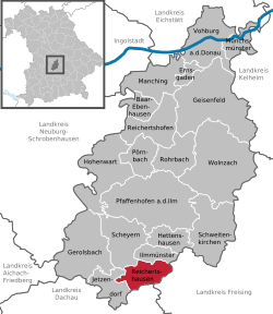 | ||
| Coordinates: 48°28′N 11°31′E / 48.467°N 11.517°ECoordinates: 48°28′N 11°31′E / 48.467°N 11.517°E | ||
| Country | Germany | |
| State | Bavaria | |
| Admin. region | Oberbayern | |
| District | Pfaffenhofen a.d.Ilm | |
| Government | ||
| • Mayor | Reinhard Heinrich (CSU) | |
| Area | ||
| • Total | 23.59 km2 (9.11 sq mi) | |
| Elevation | 448 m (1,470 ft) | |
| Population (2017-12-31)[1] | ||
| • Total | 5,041 | |
| • Density | 210/km2 (550/sq mi) | |
| Time zone | CET/CEST (UTC+1/+2) | |
| Postal codes | 85293 | |
| Dialling codes | 08441, 08137 | |
| Vehicle registration | PAF | |
| Website | www.reichertshausen.de | |

Reichertshausen is a municipality in the district of Pfaffenhofen in Bavaria in Germany and is near the A9 and between Munich and Ingolstadt.
Geography
The Bundesstrasse 13 (B13) runs through Reichertshausen. Also the river Ilm, which gives the valley (Ilmtal) its name and is a tributary to the Abens, runs through the town.
District
- Bärnhausen
- Grafing
- Gründholm
- Gurnöbach
- Haunstetten
- Kreut
- Langwaid
- Lausham
- Salmading
- Oberpaindorf
- Paindorf
- Pischelsdorf
- Steinkirchen
References
- ↑ "Fortschreibung des Bevölkerungsstandes". Bayerisches Landesamt für Statistik und Datenverarbeitung (in German). September 2018.
Towns and municipalities in Pfaffenhofen | ||
|---|---|---|
This article is issued from
Wikipedia.
The text is licensed under Creative Commons - Attribution - Sharealike.
Additional terms may apply for the media files.