McMurrich/Monteith
| McMurrich/Monteith | |
|---|---|
| Township (single-tier) | |
| Township of McMurrich/Monteith | |
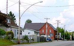 Sprucedale | |
 McMurrich/Monteith | |
| Coordinates: 45°27′N 79°29′W / 45.450°N 79.483°WCoordinates: 45°27′N 79°29′W / 45.450°N 79.483°W | |
| Country |
|
| Province |
|
| District | Parry Sound |
| Incorporated | January 1, 1998 |
| Government | |
| • Type | Township |
| • Reeve | Joanne Griffiths |
| • Federal riding | Parry Sound—Muskoka |
| • Prov. riding | Parry Sound—Muskoka |
| Area[1] | |
| • Land | 277.92 km2 (107.31 sq mi) |
| Population (2016)[1] | |
| • Total | 824 |
| • Density | 3.0/km2 (8/sq mi) |
| Time zone | UTC-5 (EST) |
| • Summer (DST) | UTC-4 (EDT) |
| Postal Code | P0A |
| Area code(s) | 705 |
| Website | www.mcmurrichmonteith.com |
McMurrich/Monteith is a municipality and census subdivision in the Almaguin Highlands region of Parry Sound District, Ontario, Canada.
The municipality was formed in 1998 through an amalgamation of the former Township of McMurrich and the eastern two-thirds of the unincorporated Township of Monteith. The remaining portion of Monteith became part of Seguin. Part of the area's name is named for John McMurrich.
Communities
The township includes the communities of Axe Lake, Banbury, Bear Lake, Bourdeau, Haldane Hill, McMurrich, Sprucedale and Whitehall.
Demographics
Population trend:[2]
- Population in 2016: 824 (2011 to 2016 population change: 5.8%)
- Population in 2011: 779 (2006 to 2011 population change: -1.5%)
- Population in 2006: 791
- Population in 2001: 766
- Population in 1996: 723 (adjusted for boundary changes)
According to the 2016 Census,[1] McMurrich/Monteith has a population of 824 people over a territory of 278.13 km². The number of private dwellings occupied by usual residents were 386, out of a total of 839 dwellings.
Mother tongue statistics for the 2006 census [3] are as follows:
- English as first language: 90.6%
- French as first language: 1.9%
- English and French as first language: 0%
- Other as first language: 7.5%
Lakes
- Doe Lake
- Buck Lake
- Axe Lake
- Johnson Lake
- Hunters Lake
- Bear Lake
- Horn Lake
See also
References
External links
- Township of McMurrich/Monteith
- Sprucedale Ontario Almaguin Highlands Regional Portal
- Bear Lake Ontario Almaguin Highlands Regional Portal
- Sprucedale Seniors' Friendship Club Sprucedale Seniors' Friendship Club
Places adjacent to McMurrich/Monteith | ||||||||||
|---|---|---|---|---|---|---|---|---|---|---|
| ||||||||||
| Towns | 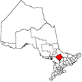 | |
|---|---|---|
| Townships | ||
| Villages | ||
| First Nations | ||
| Indian reserves | ||
| Local services boards | ||
| Unorganized areas | ||
| ||