Joly, Ontario
| Joly | |
|---|---|
| Township (single-tier) | |
| Township of Joly | |
 South River-Sundridge District Airport | |
 Joly | |
| Coordinates: 45°47′N 79°15′W / 45.783°N 79.250°WCoordinates: 45°47′N 79°15′W / 45.783°N 79.250°W | |
| Country | Canada |
| Province | Ontario |
| District | Parry Sound |
| Government | |
| • Type | Township |
| • Reeve | Bruce Baker |
| • Federal riding | Parry Sound—Muskoka |
| • Prov. riding | Parry Sound—Muskoka |
| Area[1] | |
| • Land | 194.73 km2 (75.19 sq mi) |
| Population (2016)[1] | |
| • Total | 304 |
| • Density | 1.6/km2 (4/sq mi) |
| Time zone | UTC-5 (EST) |
| • Summer (DST) | UTC-4 (EDT) |
| Postal Code | P0A |
| Area code(s) | 705 |
Joly is a township in the Almaguin Highlands region of Parry Sound District of the Canadian province of Ontario.
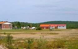
The township has no named communities within its boundaries; all addresses in the township are rural routes assigned to the adjacent communities of South River, Sundridge, Hartfell or Pevensey. The South River-Sundridge District Airport is in Joly.
Demographics
Population trend:[2]
- Population in 2016: 304 (2011 to 2016 population change: 7.0%) [3]
- Population in 2011: 284
- Population in 2006: 280
- Population in 2001: 290
- Population in 1996: 311
- Population in 1991: 248
Private dwellings occupied by usual residents: 135 (total dwellings: 164)
Mother tongue:[4]
- English as first language: 91.1%
- French as first language: 0%
- English and French as first language: 0%
- Other as first language: 8.9%
See also
References
- 1 2 Statistics Canada 2011 Census - Joly Census Profile
- ↑ Statistics Canada: 1996, 2001, 2006, 2011 census
- ↑ http://www12.statcan.gc.ca/census-recensement/2016/dp-pd/prof/details/page.cfm?Lang=E&Geo1=CSD&Code1=3549051&Geo2=CD&Code2=3549&Data=Count&SearchText=Joly&SearchType=Begins&SearchPR=01&B1=All&TABID=1
- ↑ "2006 Joly community profile".
External links
- Township of Joly, Township of Joly Official Web Site
Places adjacent to Joly, Ontario | |
|---|---|
| Towns | 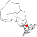 | |
|---|---|---|
| Townships | ||
| Villages | ||
| First Nations | ||
| Indian reserves | ||
| Local services boards | ||
| Unorganized areas | ||
| ||
This article is issued from
Wikipedia.
The text is licensed under Creative Commons - Attribution - Sharealike.
Additional terms may apply for the media files.