Unorganized Centre Parry Sound District
| Unorganized Centre Parry Sound District | |
|---|---|
| Unorganized area | |
| Parry Sound, Unorganized, Centre Part | |
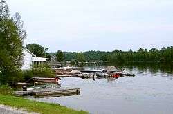
 Britt and Byng Inlet | |
 | |
| Coordinates: 45°55′N 80°00′W / 45.917°N 80.000°WCoordinates: 45°55′N 80°00′W / 45.917°N 80.000°W | |
| Country |
|
| Province |
|
| District | Parry Sound |
| Government | |
| • Federal riding | Parry Sound—Muskoka |
| • Prov. riding | Parry Sound—Muskoka |
| Area[1] | |
| • Land | 2,697.64 km2 (1,041.56 sq mi) |
| Population (2016)[2] | |
| • Total | 2,143 |
| • Density | 0.9/km2 (2/sq mi) |
| Time zone | UTC-5 (EST) |
| • Summer (DST) | UTC-4 (EDT) |
| Postal Code | P0G, P0H |
| Area code(s) | 705 |
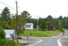
Loring
Port Loring
Unorganized Centre Parry Sound District is an unorganized area in central Ontario, Canada, between Georgian Bay and Lake Nipissing in the District of Parry Sound. It is made up of geographic townships which have no governing bodies and which are not incorporated as municipalities. The territory consists of two non-contiguous areas, with the main part located directly south of the French River and Lake Nipissing, and east of the Georgian Bay. Shawanaga Township is a small exclave south of it along Highway 69.
Local services boards
Townships
List of townships with its communities:
- Blair Township (Ess Narrows Landing, Lost Channel)
- East Mills Township (Arnstein, Loring, Port Loring)
- Hardy Township (Spring Creek)
- Henvey Township (Britt Station, Still River)
- Lount Township (Bummer's Roost, Rye, Wattenwyle)
- McConkey Township (Fleming's Landing)
- Mowat Township (Bon Air, Cranberry, Key River, Ludgate, Mowat, Pakesley, Wanikewin)
- Patterson Township (Restoule)
- Pringle Township (Bear Valley, Carr, Farleys Corners, Golden Valley)
- Shawanaga Township (Madigans)
- Wallbridge Township (Britt, Byng Inlet, Drocourt, Harris Lake, North Magnetawan)
- Wilson Township
In addition, the division also includes two geographic townships which are entirely unpopulated:
- Brown Township
- Harrison Township
Demographics
| Canada census – Parry Sound, Unorganized, Centre Part community profile | |||
|---|---|---|---|
| 2016 | 2011 | 2006 | |
| Population: | 2143 (-5.6% from 2011) | 2199 (-9.3% from 2006) | 2424 (10.3% from 2001) |
| Land area: | 2,698.17 km2 (1,041.77 sq mi) | 2,697.64 km2 (1,041.56 sq mi) | 2,660.27 km2 (1,027.14 sq mi) |
| Population density: | 0.8/km2 (2.1/sq mi) | 0.8/km2 (2.1/sq mi) | 0.9/km2 (2.3/sq mi) |
| Median age: | 61.0 (M: 60.8, F: 61.2) | 55.3 (M: 54.7, F: 56.0) | |
| Total private dwellings: | 2630 | 2637 | 3613 |
| Median household income: | $36,953 | ||
| References: 2016[3] 2011[4] 2006[5] earlier[6] | |||
Mother tongue:[7]
- English as first language: 91.5%
- French as first language: 4.6%
- English and French as first language: 0%
- Other as first language: 3.9%
Population trend:[8]
- Population in 2011: 2199
- Population in 2006: 2424
- Population in 2001: 2198
- Population in 1996: 3336 (or 2082 when adjusted to 2001 boundaries)
- Population in 1991: 3394
See also
References
- ↑ "Parry Sound, Unorganized, Centre Part census profile". 2011 Census of Population. Statistics Canada. Retrieved 2012-02-10.
- ↑ http://www12.statcan.gc.ca/census-recensement/2016/dp-pd/prof/details/page.cfm?Lang=E&Geo1=CSD&Code1=3549096&Geo2=CD&Code2=3549&Data=Count&SearchText=Parry%20Sound&SearchType=Begins&SearchPR=01&B1=All&TABID=1
- ↑ "2016 Community Profiles". Canada 2016 Census. Statistics Canada. February 21, 2017. Retrieved 2018-02-18.
- ↑ "2011 Community Profiles". Canada 2011 Census. Statistics Canada. July 5, 2013. Retrieved 2012-02-10.
- ↑ "2006 Community Profiles". Canada 2006 Census. Statistics Canada. March 30, 2011. Retrieved 2012-02-10.
- ↑ "2001 Community Profiles". Canada 2001 Census. Statistics Canada. February 17, 2012.
- ↑ Statistics Canada 2006 Census - Parry Sound, Unorganized, Centre Part community profile
- ↑ Statistics Canada: 1996, 2001, 2006 census
| Wikimedia Commons has media related to Unorganized Centre Parry Sound District. |
Jurisdictions adjacent to Unorg. Centre Parry Sound Main part | |
|---|---|
Jurisdictions adjacent to Unorg. Centre Parry Sound Southern exclave (Shawanaga Township) | ||||||||||
|---|---|---|---|---|---|---|---|---|---|---|
| ||||||||||
| Towns |  | |
|---|---|---|
| Townships | ||
| Villages | ||
| First Nations | ||
| Indian reserves | ||
| Local services boards | ||
| Unorganized areas | ||
| ||
This article is issued from
Wikipedia.
The text is licensed under Creative Commons - Attribution - Sharealike.
Additional terms may apply for the media files.