Pagolle
| Pagolle | |
|---|---|
| Commune | |
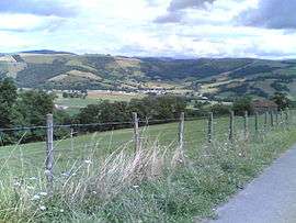 A general view of Pagolle | |
 Pagolle Location within Nouvelle-Aquitaine region  Pagolle | |
| Coordinates: 43°13′31″N 0°59′21″W / 43.2253°N 0.9892°WCoordinates: 43°13′31″N 0°59′21″W / 43.2253°N 0.9892°W | |
| Country | France |
| Region | Nouvelle-Aquitaine |
| Department | Pyrénées-Atlantiques |
| Arrondissement | Bayonne |
| Canton | Pays de Bidache, Amikuze et Ostibarre |
| Intercommunality | CA Pays Basque |
| Government | |
| • Mayor (2001–2008) | Gabriel Lopepe |
| Area1 | 15.90 km2 (6.14 sq mi) |
| Population (2006)2 | 263 |
| • Density | 17/km2 (43/sq mi) |
| Time zone | UTC+1 (CET) |
| • Summer (DST) | UTC+2 (CEST) |
| INSEE/Postal code | 64441 /64120 |
| Elevation |
130–642 m (427–2,106 ft) (avg. 304 m or 997 ft) |
|
1 French Land Register data, which excludes lakes, ponds, glaciers > 1 km2 (0.386 sq mi or 247 acres) and river estuaries. 2 Population without double counting: residents of multiple communes (e.g., students and military personnel) only counted once. | |
Pagolle (Basque: Phagola) is a commune in the Pyrénées-Atlantiques department in south-western France.
It is located in the Northern Basque Country, partly in Lower Navarre and partly in Soule, two former provinces of France.
See also
References
External links
| Wikimedia Commons has media related to Pagolle. |
This article is issued from
Wikipedia.
The text is licensed under Creative Commons - Attribution - Sharealike.
Additional terms may apply for the media files.