Larressore
| Larressore | |
|---|---|
| Commune | |
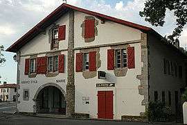 The town hall and post office of Larressore | |
 Larressore Location within Nouvelle-Aquitaine region  Larressore | |
| Coordinates: 43°22′17″N 1°26′16″W / 43.3714°N 1.4378°WCoordinates: 43°22′17″N 1°26′16″W / 43.3714°N 1.4378°W | |
| Country | France |
| Region | Nouvelle-Aquitaine |
| Department | Pyrénées-Atlantiques |
| Arrondissement | Bayonne |
| Canton | Baïgura et Mondarrain |
| Intercommunality | CA Pays Basque |
| Government | |
| • Mayor (2001–2008) | Jean-Michel Lamerens |
| Area1 | 10.76 km2 (4.15 sq mi) |
| Population (2006)2 | 1,469 |
| • Density | 140/km2 (350/sq mi) |
| Time zone | UTC+1 (CET) |
| • Summer (DST) | UTC+2 (CEST) |
| INSEE/Postal code | 64317 /64480 |
| Elevation |
5–125 m (16–410 ft) (avg. 60 m or 200 ft) |
|
1 French Land Register data, which excludes lakes, ponds, glaciers > 1 km2 (0.386 sq mi or 247 acres) and river estuaries. 2 Population without double counting: residents of multiple communes (e.g., students and military personnel) only counted once. | |
Larressore (Basque Larresoro) is a town in the traditional Basque province of Labourd, now a commune in the Pyrénées-Atlantiques department in south-western France.
See also
References
External links
| Wikimedia Commons has media related to Larressore. |
- (in Spanish) LARRESORO in the Bernardo Estornés Lasa - Auñamendi Encyclopedia (Euskomedia Fundazioa)
Municipalities in Labourd (Lapurdi) | ||
|---|---|---|
|  | |
This article is issued from
Wikipedia.
The text is licensed under Creative Commons - Attribution - Sharealike.
Additional terms may apply for the media files.