Géronce
| Géronce | |
|---|---|
| Commune | |
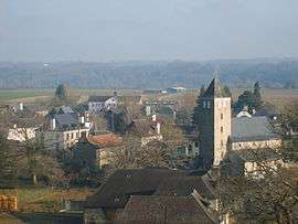 The village of Géronce | |
 Géronce Location within Nouvelle-Aquitaine region  Géronce | |
| Coordinates: 43°14′28″N 0°41′22″W / 43.2411°N 0.6894°WCoordinates: 43°14′28″N 0°41′22″W / 43.2411°N 0.6894°W | |
| Country | France |
| Region | Nouvelle-Aquitaine |
| Department | Pyrénées-Atlantiques |
| Arrondissement | Oloron-Sainte-Marie |
| Canton | Oloron-Sainte-Marie-1 |
| Intercommunality | Communauté de communes de Josbaig |
| Government | |
| • Mayor (2014–present) | Michel Contou-Carrere |
| Area1 | 15.99 km2 (6.17 sq mi) |
| Population (2006)2 | 425 |
| • Density | 27/km2 (69/sq mi) |
| Time zone | UTC+1 (CET) |
| • Summer (DST) | UTC+2 (CEST) |
| INSEE/Postal code | 64241 /64400 |
| Elevation |
167–290 m (548–951 ft) (avg. 202 m or 663 ft) |
|
1 French Land Register data, which excludes lakes, ponds, glaciers > 1 km2 (0.386 sq mi or 247 acres) and river estuaries. 2 Population without double counting: residents of multiple communes (e.g., students and military personnel) only counted once. | |
Géronce is a commune in the Pyrénées-Atlantiques department in south-western France.
Geography
Access
There are several routes leading in and out of Géronce. Route 936 linking Oloron-Sainte-Marie and Bayonne passes by the outside of the town. Route 836 passes through the middle of Géronce and links route 936 through roundabouts at Orin and at Geüs-d'Oloron. Highway 524 passes through the neighborhoods of Urein, Dous, Castéra, and Lacé, and links route 836 to route 24 via Esquiule and Barcus.
Water
The grounds in the commune are watered[1] by the "Gave d'Oloron", a river in the Pyrénées. It is also watered by the main river, the "Gave de Pau", and watered by the tributary of the "Gave d'Oloron", the "Joos" (as well as by the tributaries of the latter, the streams of Josset and Cambillou).
See also
References
- ↑ Notice du Sandre sur Géronce Archived 2007-10-23 at the Wayback Machine.
| Wikimedia Commons has media related to Géronce. |