Arette
| Arette | ||
|---|---|---|
| Commune | ||
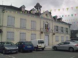 Town hall | ||
| ||
 Arette Location within Nouvelle-Aquitaine region  Arette | ||
| Coordinates: 43°05′46″N 0°42′56″W / 43.0961°N 0.7156°WCoordinates: 43°05′46″N 0°42′56″W / 43.0961°N 0.7156°W | ||
| Country | France | |
| Region | Nouvelle-Aquitaine | |
| Department | Pyrénées-Atlantiques | |
| Arrondissement | Oloron-Sainte-Marie | |
| Canton | Oloron-Sainte-Marie-1 | |
| Intercommunality | Vallée de Barétous | |
| Government | ||
| • Mayor (2001–2020) | Pierre Casabonne | |
| Area1 | 92.23 km2 (35.61 sq mi) | |
| Population (2009)2 | 1,121 | |
| • Density | 12/km2 (31/sq mi) | |
| Time zone | UTC+1 (CET) | |
| • Summer (DST) | UTC+2 (CEST) | |
| INSEE/Postal code | 64040 /64570 | |
| Elevation | 292–2,315 m (958–7,595 ft) | |
|
1 French Land Register data, which excludes lakes, ponds, glaciers > 1 km2 (0.386 sq mi or 247 acres) and river estuaries. 2 Population without double counting: residents of multiple communes (e.g., students and military personnel) only counted once. | ||
Arette (Areta in Occitan) is a commune in the Pyrénées-Atlantiques department in the Nouvelle-Aquitaine region of southwestern France. It is located in the arrondissement of Oloron-Sainte-Marie and is one of the six communes of the canton of Aramits: the other five being Ance, Aramits (commune), Féas, Issor, and Lanne-en-Barétous.

_le_Vert_d'Arette%2C_2.JPG)
Geography
Arrete is located some 15 km south by south-west of Oloron-Sainte-Marie and some 4 km south-east of Aramits. It lies close to both the French Basque region and borders Spain in the south. It is within the borders of Béarn, one of the traditional French provinces.
Access to the commune is by French rail SNCF to Pau, and a short bus ride to Arrete. Less scenic is the automobile route: D918 road from Lanne-en-Barétous in the north-west coming south-east to the village then continuing east to Issor. The D132 goes south from the village down the length of the commune following a tortuous mountain route before exiting the southern border of the commune over the Col de la Pierre St Martin (1,760m), which is also the border with Spain, and becoming the Spanish NA-137 which continues to Isaba. The D341 also goes south-east from the village then south, connecting with the D241 at the Col de Labays (1,351m) going east to join the E7 highway south of Sarrance, then continuing along the south-western border to join the D441 south of the commune. The D133 also goes north from the village to Aramits.[1]
Bus Route 848 of the Intercity Network of Pyrénées-Atlantiques (Transports 64) links Arette to Oloron-Sainte-Marie.
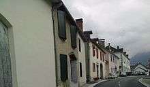
Arette is a very large commune and has a land area of 92 km2. It is also mountainous (the La Pierre Saint-Martin ski resort is within its borders, for example) and its highest peak is the 2,315 m Soum Couy, which is situated not far from the 2,504 m Pic d'Anie, the highest peak in the western Pyrenees. From Pic d'Anie the mountain range extends downwards for approximately 20 km, forming both sides of the Aspe Valley to the north-west. The Vert d'Arette (a tributary of the Vert) flows through this valley. The ancient village (also named Arette) from which the commune extends is located at an altitude of 316 m in the valley of Barétous, which lies between the aforementioned Aspe valley, to its east, and the Basque province of Soule, to its west.
Hydrography
Located in the Drainage basin of the Adour, the commune is the source of numerous tributaries of the Vert which is itself a tributary of Gave d'Oloron. The largest tributary flowing through the commune is the Vert d'Arrette however many other streams flow north towards the Vert including: the Abat Daurèye and its tributary, the Banu Erreka (accompanied by the Ruisseau de Aurèye); Ibarcis Erreka; the Lancy;[2] the Ruisseau de Gurré and its tributary the Ruisseau de Lagaretche; the Ruisseau de Hournères and its tributary, the Ouettone; the Ruisseau de Légorre and its tributary, the Cassiau de Ber; the streams of Nécore,[2] Soulayets,[2] Talu Gros, and Virgou with the tributary of the latter, the Arrigau[2] (accompanied itself in the commune by the Bachère).
The Gave de Lourdios, a tributary of the Gave d'Aspe, and its tributaries, the Arric and the Moulia (and their tributaries, Casteigt Erreka and the Ruisseau de Poussious) also pass through the commune. The Gave de Sainte-Engrâce, a tributary of the Saison, and its tributary, the Montcholako Erreka also flow in the territory of the commune.
Places and Hamlets[3]
- Abat d’Ibarry
- Adam
- Gouffre d’Ahuzthéguia
- Ambielle
- Ambile
- Cabane d’Ance
- Apons
- Pont de l’Araille
- Gouffre de l’Arbre Sec
- Pas d’Arlas[2]
- L’Arre de Bas
- Arrègle[2]
- Arritsens
- Aspit
- Aurasse
- Pont d’Aurèye[2]
- Cabane d’Auriste
- Ayesten
- Barbé
- Le Pas des Basques
- Bayrès[2]
- Bécari
- Bélatch Paoussaguia
- Bellegarde
- Bellocq
- Bernardicou
- Bersacalongue
- Ancien Moulin de Bignau
- Col de Bissouritto (995 metres)[2]
- Bitailloué
- Bonnehe
- Bonneu
- Bordehore
- Col de Boticotch
- Bois de Bouchet[2]
- Bourdès
- Bourdet
- Les Bourrugues
- Burs
- Coume de Cagastié
- Cam dét Ragutio
- Camgros
- Camou
- Candau
- Capdelabat
- Capdeville
- Pas de Caque
- Casabonne
- Casamayou
- Casaurang
- Casaux
- La Cassette
- Cassiau
- Castagne (Two places)
- Cataplous
- Cerciat
- Château-Forez
- Pédaing de Chousse[2]
- Plateau de la Chousse[2]
- Col de Cissaugue or Nécore[2]
- Pont de Cissaugue
- Costemale[2]
- Costes
- Coudure
- Couillarsut
- Cabane du Coup
- Couretcoup
- Courétot
- Les Courréges[2]
- Cousturé
- Coutchet de Lacq
- Coutchet dets Crapes
- L’Arre de Soum Couy
- La Croix du Berger
- Croix des Contrebandiers
- Davancens
- Domecq
- Fontaine Dorbe
- Source de l’Ermite
- Cabane d’Escuret de Bas
- Cabanes d’Escuret
- Esperabens
- Pas des Estes
- Estournès
- Estratte[2]
- Cabane de Féas
- Pont du Fort
- Frinchaboy
- Gabarrat
- Col de Garbas[2]
- Gesta
- Goaillardeu
- Guilhers (Sheds and fountain)[2]
- Guren
- Cap de Gurré (ruins)
- Handu
- Source d’Harrigagna
- Hondagneu
- Grange Hondagneu
- Houillis
- Houndane (spring)
- Pont du Hourat
- Houratate
- Hourcate
- Hournères[2]
- Hum
- Borde de Hum
- Ibarry - Coigt de Hecore
- Granges d’Irasts
- Coume d’Issaux
- Cabane d’Issort
- Jantet
- Labarthe
- Labatrère
- Cabanes de Labays
- Col de Labays (1,351m)
- Laborde
- Laclouque
- Lacoume
- Laculère
- Lagarde
- Lagaretche[2]
- Lagrave
- Lahore
- Pas de Lamayou
- Lancy
- Lapeyre
- Coume de Larrayet
- Larricq
- Croix de Larricq
- Le pont Larron[2]
- Camp de Larruga
- Lassalle
- Bois de Lèche[2]
- Lèchéko Zingla
- Légorre d’Ibarry[2]
- Lembeyou
- Gouffre Lépineux
- Mail de Lerre
- Létone
- Pas de la Leugue
- Libarde
- Col de Lie (601m)
- Lilles
- Longis
- Lourdios d'Arette
- La Lousère
- Lucq
- Col de Mahourat
- Le Mail blanc
- Les Malices
- Cayolar de Mantchola or Cabane d’Etchébar[2]
- Pas de Massaré
- Massaugues
- Coume Mayou
- Maysou
- Mesplou
- Bois de Métouret
- Mirassou
- Mirassou Bas
- Mirassou Haut
- Moulia
- La Mouline
- Moura
- Nario
- Nouqué
- Noutary
- Noye
- Oron
- Cabane d’Oumarre
- Bois de l’Oumbre-del-Hourcq
- Gouffre de l’Ours
- Pagnon
- Pédaing
- Pélou
- Les Pernes
- Cabane de la Pernotte (ruins)[2]
- Pescamou[2]
- Borde des Peyres
- Peyret
- Arette La Pierre Saint-Martin
- Col de la Pierre St Martin
- L’Arre Planère
- Pouey
- Poursuca
- Le Pourtet[2]
- Prat
- Granges de Prat
- La Puyade
- Rachet
- Roucam
- Pène Rouye
- Sainte-Gracie
- Saint-Marty
- Salanove
- Salet
- Salies
- Sarrelangue
- Saudiat
- Plateau de Séguitte
- Pas de Single
- Bois de Soudet
- Cabanes de Soudet
- Soulaing[2]
- Soubies
- Soubirou
- Soulé
- Borde de Soulé
- Sous Pène
- Superville
- Col de Suscousse[2] or Garatéko L’époua
- Talou
- Talou d’Arnaune
- Talou de Bouc
- Tamarpouey[2]
- Tapie
- Col de Taules
- Braca de Termy[2]
- Le Terrail
- Gouffre La Tête Sauvage
- Tourette
- Tourumy (harnessed spring)
- Col de Tremeil[2]
- Camp d’Urdette
- Zélukobortha (chasm)
Neighbouring communes and villages
Places adjacent to Arette | |
|---|---|
Toponymy
The commune name in béarnais is Arèta (according to the classical norm of Occitan). The name comes from the Basque ar- meaning "stone" and from the locative suffix -eta meaning "stony place".[4]
The following table details the origins of the commune name and other names in the commune.
| Name | Spelling | Date | Source | Page | Origin | Description |
|---|---|---|---|---|---|---|
| Arette | Areta | 1186 | Raymond | Barcelona | Village | |
| Rete | 1383 | Raymond | Luntz | |||
| Arete | 1385 | Raymond | Census | |||
| Erete | 1440 | Raymond | Barétous | |||
| Aretha | 1444 | Raymond | Cour Major | |||
| Eretha | 1444 | Raymond | Cour Major | |||
| Hereta | 1538 | Raymond | Reformation | |||
| Saint Pierre d'Arette | 1674 | Raymond | Insinuations | |||
| Arrette | 1750 | Cassini | ||||
| Arete | 1801 | Ldh/EHESS/Cassini | Bulletin des lois | |||
| Arrègle | le molii d’Arregle | 1385 | Raymond | Census | Farm and a Mill on the Vert d'Arette | |
| Aregle en Baretous | 1433 | Raymond | Notaries | |||
| Aregla | 1538 | Raymond | Reformation | |||
| Réglé | 1863 | Raymond | ||||
| Arlas | Arlas | 1538 | Raymond | Reformation | Mountain on the Spanish border | |
| L'Arrigau | lo ariu aperat la Rigau | 1538 | Raymond | Reformation | A stream rising in Arette and which joins the Vert at Aramits | |
| L'Arrigas | 1863 | Raymond | ||||
| Aurèye | L'Aureye | 1863 | Raymond | Stream rising in Arette, tributary of the Vert | ||
| Bayrès | Bayres | 1538 | Raymond | Reformation | Farm | |
| Bayres | 1863 | Raymond | ||||
| Col de Bissourritto | Col de Bissourritte | 1863 | Raymond | Mountain Pass | ||
| Bois de Bouchet | Bouchette | 1863 | Raymond | Wood | ||
| La Chousse | La Chousse | 1863 | Raymond | Stream rising in Arette, a tributary of the Vert | ||
| Costemale | Costemale | 1863 | Raymond | Mountain | ||
| Les Courréges | Les Courréges | 1863 | Raymond | Mountain | ||
| Estratte | Estrate | 1385 | Raymond | Census | Farm | |
| Estrata | 1538 | Raymond | Reformation | |||
| Estrate | 1863 | Raymond | ||||
| Col de Garbas | Col de Garbas | 1863 | Raymond | Pass between the communes of Arette and Lanne | ||
| Guilhers | Le Pas de Guilhers | 1863 | Raymond | Wood between the communes of Arette and Lées-Athas | ||
| Hournères | Le Hourner | 1863 | Raymond | Stream rising in Arette and joining the Chousse | ||
| Lagaretche | Lagarretche | 1863 | Raymond | Wood | ||
| Le Pont Larron | Le Pont Larron | 1863 | Raymond | Bridge named after the former name of the Vert d'Arette: Larron | ||
| Lèche | La singla de Lexe | 1589 | Raymond | Reformation | Mountain and Wood | |
| Légorre d’Ibarry | Legorre | 1863 | Raymond | Mountain | ||
| Mantchola | Le Manchola | 1863 | Raymond | Stream delineating the border between Arette and Sainte-Engrâce before joining the Uhaïtxa | ||
| Le Nécore | Le Col de Nécore | 1863 | Raymond | Mountain Pass. A stream of the same name rises at the pass and joins the Vert d'Arette in Arette | ||
| Pernalatte | Pernalatte | 1863 | Raymond | Mountain | ||
| La Pernotte | La Pernotte | 1863 | Raymond | Stream, tributary of the Chousse | ||
| Pescamou | Pescamou | 1863 | Raymond | Mountain and Pass on the Spanish frontier | ||
| La Pierre Saint-Martin | La peyre de Sent-Martin, frontière de Navarre | 1589 | Raymond | Reformation | Assembly place for the inhabitants of the Barétous Valley in France and Roncal in Spain | |
| Le Pourtet | Pourtet | 1863 | Raymond | Mountain on the Spanish border extending to Arette and Lées-Athas | ||
| Le col de Soès | Le col de Soès | 1863 | Raymond | Mountain Pass | ||
| Soulaing | Soulaing | 1863 | Raymond | Mountain between Arette and Osse-en-Aspe and a stream, tributary of the Lourdios | ||
| Soulayets | Le Soulayet | 1863 | Raymond | Stream that flows through Arette and joins the Vert | ||
| Tamarpouey | Tamarpoey | 1385 | Raymond | Census | Farm | |
| Tamarpoey | 1863 | Raymond | ||||
| Le Termy | Le Termy | 1863 | Raymond | Stream rising in Arette and joining the Uhaïtxa at Sainte-Engrâce | ||
| Trémeil | Torrumie | 1703 | Raymond | Regulation | Mountain across Arette and Lanne | |
| Tremeilh | 1863 | Raymond |
Sources:
- Raymond: Topographic Dictionary of the Department of Basses-Pyrenees, 1863, on the page numbers indicated in the table. (in French)[2]
- Grosclaude: Toponymic Dictionary of communes, Béarn, 2006 (in French)[4]
- Cassini: Cassini Map from 1750[5]
- Ldh/EHESS/Cassini: Ldh/EHESS/Cassini database (in French)
Origins:
- Barcelona: Titles of Barcelona.[6]
- Luntz:[7]
- Census: Census of Béarn[8]
- Barétous: Titles of the Valley of Barétous
- Cour Major: Regulations of the Cour Major[9]
- Reformation: Reformation of Béarn[10]
- Insinuations: Insinuations of the Diocese of Oloron[11]
- Notaries: Notaries of Oloron[12]
- Regulation: Regulation of Arette[13]
History
In 1385 there were 87 fires in Arette and it depended on the Bailiwick of Oloron.[2]
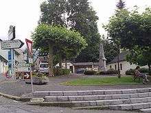
On 13 August 1967 the village of Arette was 80% destroyed by an earthquake that killed one person. The ruined clock tower of the church indicated the exact time of the earthquake: 11:10 p.m. Seismic waves were felt from Pau to Tarbes and Bayonne.[14]
Heraldry
.svg.png) |
Blazon: Quarterly, 1 and 4 Gules with two cows of Or hooved, collared, belled, and horned in Azure one above the other; 2 and 3 Argent with a boar of Sable. |
Administration
List of Successive Mayors[15]
| From | To | Name | Party | Position |
|---|---|---|---|---|
| 1793 | 1800 | Ignace Camou | ||
| 1800 | 1807 | Jean Lasalle | ||
| 1808 | 1813 | Pierre Hum | ||
| 1813 | 1831 | Jean-Pierre Salet | ||
| 1831 | 1835 | Jean Carrère | ||
| 1835 | 1837 | Pierre Camgros | ||
| 1837 | 1843 | Étienne Superville | ||
| 1843 | 1848 | Jean-François Sérée | ||
| 1848 | 1853 | Pierre-Joseph Castéran | ||
| 1853 | 1856 | Jean-François Sérée | ||
| 1857 | 1861 | Philippe Salies | ||
| 1861 | 1872 | Charles-Henri Fischer | ||
| 1872 | 1877 | Jean Bergé | ||
| 1877 | 1884 | Charles-Henri Fischer | ||
| 1884 | 1890 | Emmanuel Salet | ||
| 1890 | 1892 | François Dabancens | ||
| 1892 | 1894 | Charles-Henri Fischer | ||
| 1894 | 1906 | Jean-Baptiste Labourdette | ||
| 1906 | 1907 | Vincent Lagrave | ||
| 1907 | 1916 | Bernard Trébucq | ||
| 1919 | 1942 | Pierre Casabonne |
- Mayors from 1942
| From | To | Name | Party | Position |
|---|---|---|---|---|
| 1942 | 1952 | Michel Lagrave | ||
| 1952 | 1989 | Jean-Marie Lonne-Peyret | ||
| 1989 | 2001 | Joseph Arrègle | ||
| 2001 | 2020 | Pierre Casabonne | DVD | General Councillor |
(Not all data is known)
Inter-communality
Arette is part of six inter-communal structures:
- the Community of communes of the Barétous Valley;
- the SIVU La Verna;
- the energy association of Pyrénées-Atlantiques;
- the inter-communal association for study and management of the Drainage basin of the Vert and its tributaries;
- the joint association for la Pierre Saint-Martin;
- the joint association for Haut-Béarn.
Twinning
Demography
In 2009 the commune had 1,121 inhabitants. The evolution of the number of inhabitants is known from the population censuses conducted in the commune since 1793. From the 21st century, a census of communes with fewer than 10,000 inhabitants is held every five years, unlike larger towns that have a sample survey every year.[Note 1]
| 1793 | 1800 | 1806 | 1821 | 1831 | 1836 | 1841 | 1846 | 1851 |
|---|---|---|---|---|---|---|---|---|
| 1,762 | 1,561 | 1,826 | 2,014 | 2,139 | 2,176 | 2,245 | 2,245 | 2,218 |
| 1856 | 1861 | 1866 | 1872 | 1876 | 1881 | 1886 | 1891 | 1896 |
|---|---|---|---|---|---|---|---|---|
| 2,069 | 2,113 | 2,078 | 2,065 | 1,982 | 1,990 | 2,050 | 1,905 | 1,851 |
| 1901 | 1906 | 1911 | 1921 | 1926 | 1931 | 1936 | 1946 | 1954 |
|---|---|---|---|---|---|---|---|---|
| 1,743 | 1,734 | 1,761 | 1,444 | 1,452 | 1,404 | 1,377 | 1,309 | 1,171 |
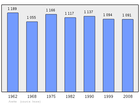
| 1962 | 1968 | 1975 | 1982 | 1990 | 1999 | 2006 | 2009 | - |
|---|---|---|---|---|---|---|---|---|
| 1,189 | 1,055 | 1,166 | 1,117 | 1,137 | 1,094 | - | 1,121 | - |
Sources : Ldh/EHESS/Cassini until 1962, INSEE database from 1968 (population without double counting and municipal population from 2006)
Distribution of Age Groups
The population of the town is relatively old. The ratio of persons above the age of 60 years (28.8%) is higher than the national average (21.6%) and the departmental average (25.9%). As with national and departmental allocations, the male population of the town is less than the female population (48.1% against 48.4% nationally and 48.2% at the departmental level).
Percentage Distribution of Age Groups in Arette and Pyrénées-Atlantiques Department in 2009
| Arette | Arette | Pyrénées-Atlantiques | Pyrénées-Atlantiques | |
|---|---|---|---|---|
| Age Range | Men | Women | Men | Women |
| 0 to 14 Years | 14.9 | 15.2 | 17.4 | 15.2 |
| 15 to 29 Years | 13.7 | 13.4 | 17.5 | 15.4 |
| 30 to 44 Years | 19.2 | 18.7 | 20.1 | 19.0 |
| 45 to 59 Years | 24.2 | 23.1 | 21.3 | 20.8 |
| 60 to 74 Years | 17.0 | 16.1 | 15.1 | 16.2 |
| 75 to 89 Years | 10.7 | 12.2 | 8.1 | 11.9 |
| 90 Years+ | 0.4 | 1.2 | 0.5 | 1.5 |
Sources:
Economy
The economy of the commune is primarily oriented toward agriculture and livestock (cattle and sheep) and logging. The town is part of the Appellation d'origine contrôlée (AOC) zone designation of Ossau-iraty.
Culture and Heritage
Civil heritage
The Barétous Museum is located in the commune. It features permanent collections on pastoralism and the Junta Roncal or "Tribute of the Three Cows".
Religious heritage
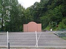
_retable.JPG)
The former Lay Abbey (17th century)![]()
The Arette Church contains several items that are registered as historical objects:
Environmental heritage
Arette Picture Gallery
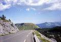 Col de la Pierre Saint Martin
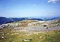 Col de la Pierre Saint Martin
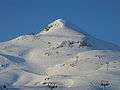 Arlas Peak
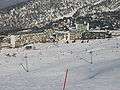 La Pierre Saint Martin Ski resort
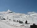 La Pierre Saint Martin ski slopes
Facilities
Education
Arette has a public college: the College of Arette Barétous[22] and a primary school.
Sports and sports facilities
The Basque pelota Club trains on the village fronton.
The town is located on the route of the 16th stage of the Tour de France 2007 which took place on 25 July. On Bastille Day 2015 the Tour will pass through the town again. 218 km route linked Orthez to Gourette - Col d'Aubisque.
The Hill-climbing event, organized since 1984, is listed as a championship of France.
Notable people linked to the commune
- Jacques I d'Arette de Béarn-Bonasse, baptized around 1600 in Béarn and died in 1666 in Saint-Castin, was a lord of Bonasse and lay abbot of Arette.
- Henri Pellisson , Félibrige and member of the Escole Gastoû Febus affiliated to Félibrige (1846-1912), first at the Acadèmia dels Jòcs Florals (Academy of Floral Games) of Toulouse in 1898 for his poem Notre Dame de Sarrance.
- Renée Massip, born in 1907 at Arette and died in Paris in 2002, he was a French writer, winner of the Prix Interallié in 1963.
- Pierre Aristouy born on 18 October 1920 at Arette and died on 20 April 1974. A former French rugby player who played with the French team and in the Section Paloise in the position of second line or prop.
- Paul Ambille, born in 1930 at Béziers and died in 2010 in Arette, was a French painter.
- Nelson Paillou, president of the CNOSF (French Olympic Committee) lived in Arette.
See also
Notes
- ↑ At the beginning of the 21st century, the methods of identification have been modified by Law No. 2002-276 of 27 February 2002 Archived 6 March 2016 at the Wayback Machine., the so-called "law of local democracy" and in particular Title V "census operations" allows, after a transitional period running from 2004 to 2008, the annual publication of the legal population of the different French administrative districts. For communes with a population greater than 10,000 inhabitants, a sample survey is conducted annually, the entire territory of these communes is taken into account at the end of the period of five years. The first "legal population" after 1999 under this new law came into force on 1 January 2009 and was based on the census of 2006.
References
- ↑ Google Maps
- 1 2 3 4 5 6 7 8 9 10 11 12 13 14 15 16 17 18 19 20 21 22 23 24 25 26 27 28 29 30 31 32 33 34 Topographic Dictionary of the Department of Basses-Pyrenees, Paul Raymond, Imprimerie nationale, 1863, Digitised from Lyon Public Library 15 June 2011 (in French)
- 1 2 3 4 5 6 7 8 9 10 11 Géoportail, IGN (in French)
- 1 2 Michel Grosclaude, Toponymic Dictionary of communes, Béarn, Edicions reclams & Édition Cairn - 2006, 416 pages, ISBN 2-35068-005-3 (in French)
- ↑ Cassini Map 1750 – Arette
- ↑ Cited by Pierre de Marca, History of Béarn
- ↑ Contracts retained by Luntz, Notary of Béarn in the Departmental Archives of Pyrénées-Atlantiques (in French)
- ↑ Manuscript from the 14th century - Departmental Archives of Pyrénées-Atlantiques (in French)
- ↑ Cour Majour of Béarn, register manuscripts from the 15th century - Departmental Archives of Pyrénées-Atlantiques (in French)
- ↑ Manuscript from the 16th to 18th centuries - Departmental Archives of Pyrénées-Atlantiques (in French)
- ↑ Manuscripts from the 17th century in the Departmental Archives of Pyrénées-Atlantiques (in French)
- ↑ Notaries of Oloron in the Departmental Archives of Pyrénées-Atlantiques (in French)
- ↑ Communal Archives (in French)
- ↑ Photographs of Arette after the earthquake (in French)
- ↑ List of Mayors of France (in French)
- ↑ National Commission for Decentralised cooperation (in French)
- ↑ Ministry of Culture, Mérimée PA00084315 Lay Abbey (in French)
- ↑ Ministry of Culture, Palissy PM64000035 Chandelier (in French)
- ↑ Ministry of Culture, Palissy PM64000034 Altar and Retable (in French)
- ↑ Ministry of Culture, Palissy PM64000033 Eagle-Lectern (in French)
- ↑ Ministry of Culture, Palissy PM64000538 Statue: Virgin and child (in French)
- ↑ College of Arette website (in French)
External links
- Arette on Lion1906
- Arrete on the 1750 Cassini Map
- Arette on the INSEE website (in French)
- INSEE (in French)
| Wikimedia Commons has media related to Arette. |