Larrau
| Larrau | |
|---|---|
| Commune | |
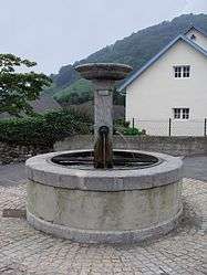 The village fountain of Larrau | |
 Larrau Location within Nouvelle-Aquitaine region  Larrau | |
| Coordinates: 43°01′11″N 0°57′16″W / 43.0197°N 0.9544°WCoordinates: 43°01′11″N 0°57′16″W / 43.0197°N 0.9544°W | |
| Country | France |
| Region | Nouvelle-Aquitaine |
| Department | Pyrénées-Atlantiques |
| Arrondissement | Oloron-Sainte-Marie |
| Canton | Montagne Basque |
| Intercommunality | CA Pays Basque |
| Government | |
| • Mayor (2008–2014) | Sébastien Uthurriague |
| Area1 | 126.80 km2 (48.96 sq mi) |
| Population (2006)2 | 209 |
| • Density | 1.6/km2 (4.3/sq mi) |
| Time zone | UTC+1 (CET) |
| • Summer (DST) | UTC+2 (CEST) |
| INSEE/Postal code | 64316 /64560 |
| Elevation |
319–2,022 m (1,047–6,634 ft) (avg. 506 m or 1,660 ft) |
|
1 French Land Register data, which excludes lakes, ponds, glaciers > 1 km2 (0.386 sq mi or 247 acres) and river estuaries. 2 Population without double counting: residents of multiple communes (e.g., students and military personnel) only counted once. | |
Larrau (Basque: Larraine) is a commune in the Pyrénées-Atlantiques department in south-western France.
It is located in the former province of Soule.
See also
References
External links
| Wikimedia Commons has media related to Larrau. |
This article is issued from
Wikipedia.
The text is licensed under Creative Commons - Attribution - Sharealike.
Additional terms may apply for the media files.