Gurmençon
| Gurmençon | |
|---|---|
| Commune | |
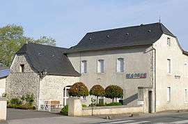 The town hall of Gurmençon | |
 Gurmençon Location within Nouvelle-Aquitaine region  Gurmençon | |
| Coordinates: 43°09′25″N 0°35′41″W / 43.1569°N 0.5947°WCoordinates: 43°09′25″N 0°35′41″W / 43.1569°N 0.5947°W | |
| Country | France |
| Region | Nouvelle-Aquitaine |
| Department | Pyrénées-Atlantiques |
| Arrondissement | Oloron-Sainte-Marie |
| Canton | Oloron-Sainte-Marie-1 |
| Intercommunality | Communauté de communes du Piémont Oloronais |
| Government | |
| • Mayor (2008–2014) | Jean Sarasola |
| Area1 | 2.98 km2 (1.15 sq mi) |
| Population (2006)2 | 861 |
| • Density | 290/km2 (750/sq mi) |
| Time zone | UTC+1 (CET) |
| • Summer (DST) | UTC+2 (CEST) |
| INSEE/Postal code | 64252 /64400 |
| Elevation |
220–277 m (722–909 ft) (avg. 266 m or 873 ft) |
|
1 French Land Register data, which excludes lakes, ponds, glaciers > 1 km2 (0.386 sq mi or 247 acres) and river estuaries. 2 Population without double counting: residents of multiple communes (e.g., students and military personnel) only counted once. | |
Gurmençon is a commune in the Pyrénées-Atlantiques department in south-western France.
See also
References
| Wikimedia Commons has media related to Gurmençon. |
This article is issued from
Wikipedia.
The text is licensed under Creative Commons - Attribution - Sharealike.
Additional terms may apply for the media files.