Bugnein
| Bugnein | |
|---|---|
| Commune | |
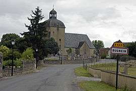 The road into Bugnein | |
 Bugnein Location within Nouvelle-Aquitaine region  Bugnein | |
| Coordinates: 43°21′12″N 0°46′51″W / 43.3533°N 0.7808°WCoordinates: 43°21′12″N 0°46′51″W / 43.3533°N 0.7808°W | |
| Country | France |
| Region | Nouvelle-Aquitaine |
| Department | Pyrénées-Atlantiques |
| Arrondissement | Oloron-Sainte-Marie |
| Canton | Le Cœur de Béarn |
| Government | |
| • Mayor (2008–2014) | Alain Sicre |
| Area1 | 11.36 km2 (4.39 sq mi) |
| Population (2009)2 | 235 |
| • Density | 21/km2 (54/sq mi) |
| Time zone | UTC+1 (CET) |
| • Summer (DST) | UTC+2 (CEST) |
| INSEE/Postal code | 64149 /64190 |
| Elevation |
98–251 m (322–823 ft) (avg. 116 m or 381 ft) |
|
1 French Land Register data, which excludes lakes, ponds, glaciers > 1 km2 (0.386 sq mi or 247 acres) and river estuaries. 2 Population without double counting: residents of multiple communes (e.g., students and military personnel) only counted once. | |
Bugnein is a commune in the Pyrénées-Atlantiques department in southwestern France.
See also
References
| Wikimedia Commons has media related to Bugnein. |
This article is issued from
Wikipedia.
The text is licensed under Creative Commons - Attribution - Sharealike.
Additional terms may apply for the media files.