Aroue-Ithorots-Olhaïby
| Aroue-Ithorots-Olhaïby | |
|---|---|
| Commune | |
_La_mairie_situ%C3%A9_%C3%A0_Aroue.JPG) The Town Hall at Aroue | |
 Aroue-Ithorots-Olhaïby Location within Nouvelle-Aquitaine region  Aroue-Ithorots-Olhaïby | |
| Coordinates: 43°19′09″N 0°54′59″W / 43.3192°N 0.9164°WCoordinates: 43°19′09″N 0°54′59″W / 43.3192°N 0.9164°W | |
| Country | France |
| Region | Nouvelle-Aquitaine |
| Department | Pyrénées-Atlantiques |
| Arrondissement | Bayonne |
| Canton | Pays de Bidache, Amikuze et Ostibarre |
| Intercommunality | CA Pays Basque |
| Government | |
| • Mayor (2014-2020) | Jean-Pierre Barneix |
| Area1 | 17.85 km2 (6.89 sq mi) |
| Population (2015)2 | 246 |
| • Density | 14/km2 (36/sq mi) |
| Time zone | UTC+1 (CET) |
| • Summer (DST) | UTC+2 (CEST) |
| INSEE/Postal code | 64049 /64120 |
| Elevation |
89–231 m (292–758 ft) (avg. 114 m or 374 ft) |
|
1 French Land Register data, which excludes lakes, ponds, glaciers > 1 km2 (0.386 sq mi or 247 acres) and river estuaries. 2 Population without double counting: residents of multiple communes (e.g., students and military personnel) only counted once. | |
Aroue-Ithorots-Olhaïby (Basque: Arüe-Ithorrotze-Olhaibi) is a commune in the Pyrénées-Atlantiques department in the Nouvelle-Aquitaine region of south-western France.
The inhabitants of the commune are known as Arouetarrak.[1]
Geography
_l'%C3%A9glise_dans_la_lumi%C3%A8re_du_matin.JPG)
_church_tower.JPG)
_st%C3%A8le_disco%C3%AFdale_1.JPG)
_st%C3%A8le_disco%C3%AFdale_2.JPG)
_vue_du_village.JPG)
_%C3%A9glise.JPG)

Aroue-Ithorots-Olhaïby is located in the former Basque province of Soule some 10 km east of Saint-Palais and 10 km south of Sauveterre-de-Béarn. Access to the commune is by the D11 road from Domezain-Berraute in the west passing through the west fork of the commune then Etcharry then the east fork and the village before continuing south-east to Charritte-de-Bas. The commune is mixed forest and farmland.[2]
Located in the Drainage basin of the Adour, the commune is traversed from south to north by the Lafoure (a tributary of the Saison) with its tributary the Hourquet and the Lauhirasse with its tributary the Thiancoenia erreka.[2]
Places and Hamlets[3]
- Abbadie (château)
- Aïntcia
- Aitzaguer
- Aroue
- Bagardoy
- Bartulague[4]
- Begorre
- Beheria
- Benoscar (Forest)
- Bentaberria
- Berhon
- Berrogain
- Bethe
- Bidauria
- Bohoteguia
- Bouhaben
- Carriquiry
- Ertorraenia
- Etchebarnia
- Etcheberria
- Etchecoin
- Etchelecu
- Etchemborde
- Eyherabide
- Garay
- Guestereguia
- Hagoua
- Harguina
- Harguinaborda
- Ithorots
- Jaureguiberria
- Joantho (château)
- Landaco
- Landuchia
- Larraburuzahar
- Larrartia
- Lassartia
- Linchinbiague
- Mendiburia
- Mendicoi
- Mendionde
- Metcha (Mill)
- Olhaïby
- Olhassaria[4]
- Oxaïby
- Oxart
- Oxidoya
- Oyhamburia
- Oyhenart-Chipi
- Oyhençabal
- Pagueguy
- Poulit
- Quillilauquy
- Salla
- Sallagaray
- Saubidet
Neighbouring communes and villages[2] | ||||||||||
|---|---|---|---|---|---|---|---|---|---|---|
| ||||||||||
Toponymy
The commune name in basque is Arüe-Ithorrotze-Olhaibi.[5]
Jean-Baptiste Orpustan indicated that Ithorots possibly signified "source of cold water" and Olhaïby "the ford of the huts".[6]
The following table details the origins of the commune name and other names in the commune.
| Name | Spelling | Date | Source | Page | Origin | Description |
|---|---|---|---|---|---|---|
| Aroue | Aroe | 1337 | Orpustan | Village | ||
| Aroa | 1385 | Raymond | Duchesne | |||
| Aroe | 1460 | Raymond | Ohix | |||
| Sent Stephen d'Aroe | 1469 | Raymond | Ohix | |||
| Degaierie de Aroa | 1520 | Orpustan | ||||
| Aroue | 1690 | Orpustan | ||||
| Aroüe | 1750 | Cassini | ||||
| Ithorots | Ithorrodz | 1337 | Orpustan | Village | ||
| Uthorrotz | 1469 | Orpustan | ||||
| Itorrotz | 1469 | Raymond | Ohix | |||
| Utorrotz | 1478 | Raymond | Ohix | |||
| Utorrotz | 1480 | Raymond | Ohix | |||
| Ytorrotz | 1482 | Raymond | Ohix | |||
| Y Ptorrotz | 1690 | Orpustan | ||||
| Iptorrotz | 1690 | Orpustan | ||||
| Ithorrotz | 1750 | Cassini | ||||
| Ittorrolz | 1801 | EHESS (1) | Bulletin des Lois | |||
| Olhaïbi | Olhaivi | 1308 | Orpustan | Village | ||
| Olhabie | 1375 | Raymond | Luntz | |||
| Olƒabie | 1376 | Raymond | Military | |||
| Olhaibie | 1385 | Raymond | Duchesne | |||
| Olhabia | 1407 | Raymond | Duchesne | |||
| Olhayvi | 1496 | Raymond | Ohix | |||
| Olharby | 1563 | Raymond | Languedoc | |||
| Olhayby | 1690 | Orpustan | ||||
| Olhaybié | 1690 | Orpustan | ||||
| Olhaybi | 1750 | Cassini | ||||
| Olhaiby | 1793 | EHESS (2) | ||||
| Abbadie | L'Abbadie | 1863 | Raymond | Lay Abbey of Ithorots, vassal of the Viscounts of Soule | ||
| Bartulague | Batrulague | 1477 | Raymond | Ohix | Farm of Ithorots-Olhaïby | |
| Barthulague | 1863 | Raymond | ||||
| Béloscar | Belhoscar | 1496 | Raymond | Ohix | Farm in Aroue | |
| Lafaure | La Phaura | 1538 | Raymond | Reformation | Stream which rises in Aroue, crosses Etcharry and joins the Saison at Espiute | |
| La Phaure | 1863 | Raymond | ||||
| Olhassaria | Olhassari | 17th century | Raymond | Arthez-Lasalle | Fief under the Viscounts of Soule | |
| Olhassarry | 1863 | Raymond |
Sources:
- Orpustan: Jean-Baptiste Orpustan, New Basque Toponymy[6] on the page numbers indicated in the table.
- Raymond: Topographic Dictionary of the Department of Basses-Pyrenees, 1863, on the page numbers indicated in the table. (in French)[4]
- Cassini: Cassini Map from 1750[7]
- EHESS (1): Ithorots-Olhaïby on the Ldh/EHESS/Cassini database (in French)
- EHESS (2): Olhaïbi on the Ldh/EHESS/Cassini database (in French)
Origins:
History
Paul Raymond noted on page 11 of his 1863 dictionary that Aroue was one of the seven districts of Soule and depended on the messagerie of Barhoue. There was a Lay Abbey at Ithorots, vassal of the Viscounts of Soule. The fief of Olhaïby was a vassal of the Viscounts of Soule and its owner was one of ten potestats of Soule.[4]
The commune had a "Temple of Reason" during the French Revolution, undoubtedly because in the Béarnais region, Aroue was the only Basque commune to adopt the Jacobin anti-religion policy.
Between 1790 and 1794 Ithorots commune was merged[15] with Olhaïby to form the new commune of Ithorots-Olhaïby. On 1 August 1973 (by prefectural order of 20 July 1973), the commune of Aroue merged with Ithorots-Olhaïby to form the new commune of Aroue-Ithorots-Olhaïby.
Administration
List of Successive Mayors[16]
| From | To | Name | Party | Position |
|---|---|---|---|---|
| 1953 | 2001 | Franz Duboscq | ||
| 2001 | 2008 | Marcel Gégu | ||
| 2008 | 2014 | Jean-Pascal Barneix | ||
| 2014 | 2020 | Jean-Pierre Barneix |
(Not all data is known)
Inter-communality
The commune is part of eight inter-communal structures:
- the Community of communes of Amikuze;
- the AEP association of Pays de Mixe;
- the AEP association of Pays de Soule;
- the educational regrouping association of Arbérats-Sillègue, Arbouet-Sussaute, Aroue, and Etcharry;
- the Energy association of Pyrénées-Atlantiques;
- the inter-communal association for the functioning of schools in Amikuze;
- the joint forestry association for oaks in the Basque and béarnais valleys;
- the association to support Basque culture.
Demography
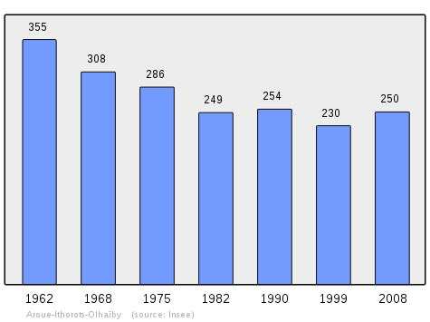
In 2009 the commune had 245 inhabitants. The evolution of the number of inhabitants is known from the population censuses conducted in the commune since 1793. From the 21st century, a census of communes with fewer than 10,000 inhabitants is held every five years, unlike larger towns that have a sample survey every year.[Note 1]
| 1793 | 1800 | 1806 | 1821 | 1831 | 1836 | 1841 | 1846 | 1851 |
|---|---|---|---|---|---|---|---|---|
| 464 | 379 | 543 | 509 | 514 | 555 | 535 | 500 | 506 |
| 1856 | 1861 | 1866 | 1872 | 1876 | 1881 | 1886 | 1891 | 1896 |
|---|---|---|---|---|---|---|---|---|
| 506 | 466 | 393 | 400 | 402 | 368 | 340 | 355 | 352 |
| 1901 | 1906 | 1911 | 1921 | 1926 | 1931 | 1936 | 1946 | 1954 |
|---|---|---|---|---|---|---|---|---|
| 328 | 345 | 326 | 268 | 277 | 254 | 249 | 270 | 265 |
| 1962 | 1968 | 1975 | 1982 | 1990 | 1999 | 2006 | 2009 | - |
|---|---|---|---|---|---|---|---|---|
| 268 | 223 | 286 | 249 | 254 | 230 | 246 | 245 | - |
Sources : Ldh/EHESS/Cassini until 1962, INSEE database from 1968 (population without double counting and municipal population from 2006)
Economy
The town is part of the Appellation d'origine contrôlée (AOC) zone of Ossau-iraty.
Culture and Heritage
Civil heritage
The village has architecture typical of the eastern Basque Country: gable roofs covered with tiles, whitewashed walls with houses from the 16th century.
As in many Basque villages, the fronton is adjacent to the church.
Religious heritage
Two churches are registered as historical monuments:
- The Church of Saint-Étienne at Aroue (12th century)

- The Church of Saint-Samson at Ithorots (19th century)
- The Church at Olhaïby has several items that are registered as historical objects:
- A Retable over the main altar (18th century)

- A Candlestick (17th century)
- An altar cross (18th century)
- A tabernacle at the main altar (18th century)
- A candlestick (18th century)
- Statuettes (18th century)
- A Painting: The Martyrdom of Saints Cyr and Judith (18th century)
- A Tabernacle, Retable, 2 Candlesticks, Statues, Altar Cross, and Painting (18th century)
- A Processional Cross (18th century)
- A Retable over the main altar (18th century)
Environmental heritage
The town lies on the GR 65. It is at the beginning of the 7th section of the GR which is listed by UNESCO as World Heritage. The presentation file to UNESCO locates the commune on the Via Podiensis on the Way of St. James. There is no real historical justification for this but it is an important fact for this small town. Justification was found by Dr. Urrutibetehy, the pioneer who traced the paths in the region (it was he who set up the so-called Stele of Gibraltar and made a point of convergence of these paths). He saw in the horseman shown on the lintel of the door of the sacristy, a representation of Saint Jacques Matamoros.
Notable people linked to the commune
- Franz Duboscq, born in Saint-Jean-de-Luz in 1924, MP and senator, former president of the council and mayor of the town until 2001.
See also
External links
- ITHORROTZE and OLHAIBI in the Bernardo Estornés Lasa - Auñamendi Encyclopedia (Euskomedia Fundazioa) (in Spanish)
- Aroue and the 7th stage of GR 65 registered as World Heritage (in French)
- Aroue-Ithorots-Olhaïby on Lion1906
- Aroue-Ithorots-Olhaïby on Google Maps
- Aroue-Ithorots-Olhaïby on Géoportail, National Geographic Institute (IGN) website (in French)
- Aroüe, Ittorrotz, and Olliaybi on the 1750 Cassini Map
- Aroue-Ithorots-Olhaïby on the INSEE website (in French)
- INSEE (in French)
Notes and references
Notes
- ↑ At the beginning of the 21st century, the methods of identification have been modified by Law No. 2002-276 of 27 February 2002 Archived 6 March 2016 at the Wayback Machine., the so-called "law of local democracy" and in particular Title V "census operations" allows, after a transitional period running from 2004 to 2008, the annual publication of the legal population of the different French administrative districts. For communes with a population greater than 10,000 inhabitants, a sample survey is conducted annually, the entire territory of these communes is taken into account at the end of the period of five years. The first "legal population" after 1999 under this new law came into force on 1 January 2009 and was based on the census of 2006.
References
- ↑ Inhabitants of Pyrénées-Atlantiques (in French)
- 1 2 3 Google Maps
- ↑ Géoportail, IGN (in French)
- 1 2 3 4 Topographic Dictionary of the Department of Basses-Pyrenees, Paul Raymond, Imprimerie nationale, 1863, Digitised from Lyon Public Library 15 June 2011 (in French)
- ↑ Euskaltzaindia - Academy of the Basque language (in Basque)
- 1 2 Jean-Baptiste Orpustan, New Basque Toponymy, Presses universitaires de Bordeaux, 2006, ISBN 2 86781 396 4 (in French)
- ↑ Cassini Map 1750 – Ithorrots
- ↑ Duchesne Collection, volumes 99 to 114, containing the papers of Oihenart, former Imperial Librarian - Bibliothèque nationale de France
- ↑ Manuscripts from the 15th century in the Departmental Archives of Pyrénées-Atlantiques (in French)
- ↑ Contracts retained by Luntz, Notary of Béarn in the Departmental Archives of Pyrénées-Atlantiques (in French)
- ↑ Manuscript from 1376 in the Departmental Archives of Pyrénées-Atlantiques (in French)
- ↑ Confessions of Languedoc in the Archives of the Empire (in French)
- ↑ Manuscript from the 16th to 18th centuries - Departmental Archives of Pyrénées-Atlantiques (in French)
- ↑ Titles of the Arthez-Lassalle family at Tardets (in French)
- ↑ Ithorots-Olhaïby on the Ldh/EHESS/Cassini database (in French)
- ↑ List of Mayors of France (in French)
- ↑ Ministry of Culture, Mérimée IA64000685 Church of Saint-Étienne (in French)
- ↑ Ministry of Culture, Mérimée IA64000692 Church of Saint-Samson (in French)
- ↑ Ministry of Culture, Palissy PM64000546 Retable (in French)
- ↑ Ministry of Culture, Palissy PM64000545 Candlestick (in French)
- ↑ Ministry of Culture, Palissy PM64000544 Altar Cross (in French)
- ↑ Ministry of Culture, Palissy PM64000543 Tabernacle (in French)
- ↑ Ministry of Culture, Palissy PM64000542 Candlestick (in French)
- ↑ Ministry of Culture, Palissy PM64000541 Statuettes (in French)
- ↑ Ministry of Culture, Palissy PM64000540 Painting: The Martyrdom of Saints Cyr and Judith (in French)
- ↑ Ministry of Culture, Palissy PM64000539 Tabernacle, Retable, 2 Candlesticks, Statues, Altar Cross, and Painting (in French)
- ↑ Ministry of Culture, Palissy PM64000198 Processional Cross (in French)
| Wikimedia Commons has media related to Aroue-Ithorots-Olhaïby. |