Angous
| Angous | |
|---|---|
| Commune | |
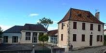
 The road into Angous | |
 Angous Location within Nouvelle-Aquitaine region  Angous | |
| Coordinates: 43°17′41″N 0°48′45″W / 43.2947°N 0.8125°WCoordinates: 43°17′41″N 0°48′45″W / 43.2947°N 0.8125°W | |
| Country | France |
| Region | Nouvelle-Aquitaine |
| Department | Pyrénées-Atlantiques |
| Arrondissement | Oloron-Sainte-Marie |
| Canton | Le Cœur de Béarn |
| Intercommunality | Canton de Navarrenx |
| Government | |
| • Mayor (2014-2020) | Francis Lansalot-Matras |
| Area1 | 6.22 km2 (2.40 sq mi) |
| Population (2014)2 | 107 |
| • Density | 17/km2 (45/sq mi) |
| Time zone | UTC+1 (CET) |
| • Summer (DST) | UTC+2 (CEST) |
| INSEE/Postal code | 64025 /64190 |
| Elevation |
133–262 m (436–860 ft) (avg. 177 m or 581 ft) |
|
1 French Land Register data, which excludes lakes, ponds, glaciers > 1 km2 (0.386 sq mi or 247 acres) and river estuaries. 2 Population without double counting: residents of multiple communes (e.g., students and military personnel) only counted once. | |
Angous is a commune in the Pyrénées-Atlantiques department in the Nouvelle-Aquitaine region of southwestern France.
The inhabitants of the commune are known as Angousiens or Angousiennes [1]
Geography
Angous is located some 5 km south-west of Navarrenx and 12 km north-east of Mauléon-Licharre. It can be accessed by the D2 road which runs from Navarrenx and forms the south-eastern border of the commune before continuing to Moncayolle-Larrory-Mendibieu. Access to the village is by the D69 road which runs off the D2 to the village. The commune consists of mainly farmland with patches of forest.[2]
Located on the watershed of the Adour, the Serrot, a tributary of the Lausset, with many tributaries flows through the commune from south-west to north-east passing near the village. The Ruisseau de Lassere with many tributaries also flows from the south-west towards the northeast to the east of the village and forms part of the eastern border.
Places and Hamlets
- Beigbédé
- Bestit
- Bois de Carrié
- Bonnehoun
- Bordenave
- Cabane
- Caillau[3]
- Carrié
- Chincas
- Claverie
- Denis
- Jaquet
- Labadie
- Labatut
- Labourdette
- Lagrave
- Lahaderne
- Larrieu
- Lartigue
- Lauga
- Ligaray
- Maréchal
- Miranda
- Mirassou
- Montjoye
- Mouliet
- Nabarre (ruins)
- Olive
- Parfouby
- Poumirau
- Pucheu
- Serbielle[3]
- Serrot[3]
- Trouilh
Neighbouring communes and villages
Places adjacent to Angous | |
|---|---|
Toponymy
The commune name in Gascon is Angós which means "marshy terrain" according to Michel Grosclaude[4] and Brigitte Jobbé-Duval[5]
The following table details the origins of the commune name and other names in the commune.
| Name | Spelling | Date | Source | Page | Origin | Description |
|---|---|---|---|---|---|---|
| Angous | Angos | 1385 | Raymond | Census | Village | |
| Anguos | 1548 | Raymond | Reformation | |||
| Saint-André d'Angous | 1673 | Raymond | Insinuations | |||
| Angous | 1750 | Cassini | ||||
| Angoust | 1793 | Ldh/EHESS/Cassini | ||||
| Angons | 1801 | Ldh/EHESS/Cassini | Bulletin des Lois | |||
| Caillau | Caillau | 1863 | Raymond | Fief | ||
| Dalen | Dalen | 1863 | Raymond | Farm | ||
| Les Navailles | Navaillez | 1366 | Raymond | Chapter of Navailles | Hamlet, former commune founded in 1366 | |
| Los Nabalhes | 1385 | Raymond | Census | |||
| Los Navalhees d'Angos | 1412 | Raymond | Notaries | |||
| Los quoate Nabalhes | 1538 | Raymond | Reformation | |||
| Les Navaillès | 1593 | Raymond | Angous | |||
| Les Randuches | Les Randuches | 1366 | Raymond | Chapter of Navailles | Hamlet | |
| Serbielle | Serviele | 1385 | Raymond | Census | Farm | |
| Servielle | 1863 | Raymond | ||||
| Serrot | Serrot | 1863 | Raymond | Census | Hamlet |
Sources:
- Raymond: Topographic Dictionary of the Department of Basses-Pyrenees, 1863, on the page numbers indicated in the table. (in French)[3]
- Grosclaude: Toponymic Dictionary of communes, Béarn, 2006 (in French)[4]
- Cassini: Cassini Map from 1750[6]
- Ldh/EHESS/Cassini: Cassini Database (in French)
Origins:
History
Paul Raymond noted on page 6 of the 1863 dictionary that the commune had a Lay Abbey, a vassal of the Viscount of Béarn. In 1385 there were 12 fires in Angous and it depended on the bailiwick of Navarrenx.[3]
The barony of Gabaston, a vassal of the Viscount of Béarn, was made up of Angous, Navailles, and Susmiou.[3]
Administration
List of Successive Mayors[12]
| From | To | Name | Party | Position |
|---|---|---|---|---|
| 1995 | 2001 | David Layous | ||
| 2001 | 2008 | Roger Eyheremendy | ||
| 2008 | 2020 | Francis Lansalot-Matras |
(Not all data is known)
Inter-communality
The commune is part of six inter-communal structures:
- the Community of communes of the Canton of Navarrenx;
- the inter-communal association for gaves and of Saleys;
- the mixed forestry association for the oak groves in the Basque and béarnais valleys;
- the collection association of Navarrenx;
- the AEP association of Navarrenx;
- the energy association of Pyrénées-Atlantiques.
Demography
In 2009 the commune had 106 inhabitants. The evolution of the number of inhabitants is known from the population censuses conducted in the commune since 1793. From the 21st century, a census of communes with fewer than 10,000 inhabitants is held every five years, unlike larger towns that have a sample survey every year.[Note 1]
| 1793 | 1800 | 1806 | 1821 | 1831 | 1836 | 1841 | 1846 | 1851 |
|---|---|---|---|---|---|---|---|---|
| 342 | 356 | 383 | 352 | 385 | 387 | 372 | 382 | 365 |
| 1856 | 1861 | 1866 | 1872 | 1876 | 1881 | 1886 | 1891 | 1896 |
|---|---|---|---|---|---|---|---|---|
| 351 | 325 | 317 | 291 | 289 | 305 | 265 | 278 | 270 |
| 1901 | 1906 | 1911 | 1921 | 1926 | 1931 | 1936 | 1946 | 1954 |
|---|---|---|---|---|---|---|---|---|
| 273 | 242 | 261 | 250 | 249 | 228 | 225 | 214 | 224 |
| 1962 | 1968 | 1975 | 1982 | 1990 | 1999 | 2006 | 2009 | - |
|---|---|---|---|---|---|---|---|---|
| 196 | 158 | 151 | 129 | 121 | 111 | 103 | 106 | - |
Sources : Ldh/EHESS/Cassini until 1962, INSEE database from 1968 (population without double counting and municipal population from 2006)


Economy
The activity is directed mainly towards agriculture (livestock grazing, market gardening, and horticultural crops). The town is part of the Appellation d'origine contrôlée (AOC) zone of Ossau-iraty.
Culture and Heritage
Religious heritage
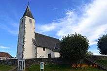
The Parish Church of Saint-André (1847)![]()
- Church Gallery
 Church Interior
 Baptismal Font
The sect Tabitha's place has a property of eleven hectares in the commune.
See also
Notes
- ↑ At the beginning of the 21st century, the methods of identification have been modified by law No. 2002-276 of 27 February 2002 Archived 2016-03-06 at the Wayback Machine., the so-called "law of local democracy" and in particular Title V "census operations" allows, after a transitional period running from 2004 to 2008, the annual publication of the legal population of the different French administrative districts. For communes with a population greater than 10,000 inhabitants, a sample survey is conducted annually, the entire territory of these communes is taken into account at the end of the period of five years. The first "legal population" after 1999 under this new law came into force on 1 January 2009 and was based on the census of 2006.
References
- ↑ Inhabitants of Pyrénées-Atlantiques (in French)
- ↑ Google Maps
- 1 2 3 4 5 6 Topographic Dictionary of the Department of Basses-Pyrenees, Paul Raymond, Imprimerie nationale, 1863, Digitised from Lyon Public Library 15 June 2011 (in French)
- 1 2 Michel Grosclaude, Toponymic Dictionary of communes, Béarn, Edicions reclams & Édition Cairn - 2006, 416 pages, ISBN 2-35068-005-3 (in French)
- ↑ Brigitte Jobbé-Duval, Dictionary of place names - Pyrénées-Atlantiques, 2009, Archives and Culture, ISBN 978-2-35077-151-9 (in French)
- ↑ Cassini Map 1750 – Angous
- ↑ Manuscript from the 14th century - Departmental Archives of Pyrénées-Atlantiques (in French)
- ↑ Manuscript from the 16th to 18th centuries - Departmental Archives of Pyrénées-Atlantiques (in French)
- ↑ Manuscripts from the 17th century in the Departmental Archives of Pyrénées-Atlantiques (in French)
- ↑ Notaries of Navarrenx in the Departmental Archives of Pyrénées-Atlantiques (in French)
- ↑ Titles of Angous in the Departmental Archives of Pyrénées-Atlantiques (in French)
- ↑ List of Mayors of France
- ↑ Ministry of Culture, Mérimée IA64000569 Parish Church of Saint-André (in French)
External links
- Angous on the Community of communes of the Canton of Navarrenx website (in French)
- Angous on Lion1906
- Angous on the 1750 Cassini Map
- Angous on the INSEE website (in French)
- INSEE (in French)
| Wikimedia Commons has media related to Angous. |