Lasseubetat
| Lasseubetat | |
|---|---|
| Commune | |
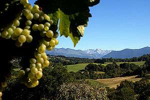 Jurançon vineyard and landscape | |
 Lasseubetat Location within Nouvelle-Aquitaine region  Lasseubetat | |
| Coordinates: 43°10′19″N 0°27′27″W / 43.1719°N 0.4575°WCoordinates: 43°10′19″N 0°27′27″W / 43.1719°N 0.4575°W | |
| Country | France |
| Region | Nouvelle-Aquitaine |
| Department | Pyrénées-Atlantiques |
| Arrondissement | Oloron-Sainte-Marie |
| Canton | Oloron-Sainte-Marie-2 |
| Government | |
| • Mayor (2014–2020) | Aimé Soumet |
| Area1 | 7.06 km2 (2.73 sq mi) |
| Population (2013)2 | 199 |
| • Density | 28/km2 (73/sq mi) |
| Time zone | UTC+1 (CET) |
| • Summer (DST) | UTC+2 (CEST) |
| INSEE/Postal code | 64325 /64290 |
| Elevation |
198–445 m (650–1,460 ft) (avg. 377 m or 1,237 ft) |
|
1 French Land Register data, which excludes lakes, ponds, glaciers > 1 km2 (0.386 sq mi or 247 acres) and river estuaries. 2 Population without double counting: residents of multiple communes (e.g., students and military personnel) only counted once. | |
Lasseubetat is a commune in the Pyrénées-Atlantiques department and Nouvelle-Aquitaine region of south-western France.
See also
References
| Wikimedia Commons has media related to Lasseubetat. |
This article is issued from
Wikipedia.
The text is licensed under Creative Commons - Attribution - Sharealike.
Additional terms may apply for the media files.