Agali, Palakkad
| Agali അഗളി | |
|---|---|
| town | |
 Agali Location in Kerala, India  Agali Agali (India) | |
| Coordinates: 11°06′04″N 76°38′51″E / 11.1012°N 76.6474°ECoordinates: 11°06′04″N 76°38′51″E / 11.1012°N 76.6474°E | |
| Country |
|
| State | Kerala |
| District | Palakkad |
| Languages | |
| • Official | Malayalam, English |
| Time zone | UTC+5:30 (IST) |
Agali (Malayalam: അഗളി) is a small town in Palakkad district in the state of Kerala, India. It forms a part of the Agali gram panchayat.[1]
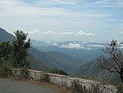
Silent Valley National Park
Agali is the nearest town for travelling to Silent Valley National Park. There are three Lodges and several resorts in Agali town catering to tourists coming to Silent Valley. The Park is 16 km from Agali. Agali is only
Demographics
As of 2001 India census, Agali had a population of 20,142 with 10,099 males and 10,043 females.[2]
There are 192 hamlets in Agali. The population of the valley is mostly Muduga, Irula and Kurumba tribal people with a small section of settlers from Tamil Nadu and Other Districts of Kerala.
Transportation
Agali is 36 km from Mannarkkad in Kerala. The little town of Anakkatty on Tamil Nadu border is only 16 km from Agali. Buses from Coimbatore come to Agali through Anakkatty and the distance is 45 km.
References
| Wikivoyage has a travel guide for Agali Hills. |
- ↑ "Reports of National Panchayat Directory". Ministry of Panchayati Raj. Archived from the original on 30 December 2013. Retrieved 30 December 2013.
- ↑ "Census of India : Villages with population 5000 & above". Registrar General & Census Commissioner, India. Archived from the original on 2008-12-08. Retrieved 2008-12-10.