Nyandarua County
| Nyandarua County | |||
|---|---|---|---|
| County | |||
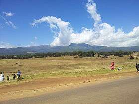 Aberdare Ranges in Nyandarua County | |||
| |||
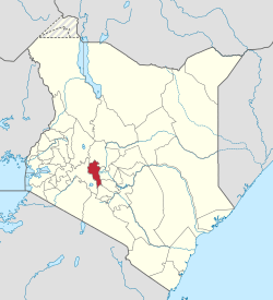 Location in Kenya | |||
| Country |
| ||
| Formed | March 4th 2013 | ||
| Capital | Ol Kalou | ||
| Government | |||
| • Governor | Francis Kimemia | ||
| Area | |||
| • Total | 3,107.7 km2 (1,199.9 sq mi) | ||
| Population (2009) | |||
| • Total | 596,268 [1] | ||
| Time zone | UTC+3 (EAT) | ||
| Website | nyandarua.go.ke | ||

Nyandarua County is a County in the former Central Province of Kenya. Its capital and largest town is Ol Kalou.[2] Formerly the capital was Nyahururu, which is now part of the Laikipia County. Nyandarua County has population of 596,268 [1] and an area of 3,304 km².[3] The county is located on the northwestern part of the old Central Province, and contains the Aberdare Ranges.
The county was split into two in 2007: Nyandarua North District and Nyandarua South District. However, with the promulgation in 2010 of new constitution, these have been re-organised as sub counties of Nyandarua County . Daniel Waithaka was elected the first governor of the County 2013 General Election and Francis Kimemia seconds him in August 2017 elections.
Demographics
| Authority | Type | Population* | Urban pop.* |
|---|---|---|---|
| Ol Kalou | Town | 47,795 | 15,186 |
| Nyandarua | County | 432,107 | 21,868 |
| Total | - | 479,902 | 37,054 |
| * 1999 census. Source:[4] | |||
Administrative divisions
| Sub-County | Population* | Urban pop.* | Headquarters |
|---|---|---|---|
| Kipipiri | 78,893 | 208 | Kipipiri |
| Ndaragwa | 85,245 | 3,594 | Ndaragwa |
| North Kinangop | 67,356 | 4,080 | |
| Ol Joro Orok | 65,229 | 0 | Ol Joro Orok |
| Ol Kalou | 98,806 | 3,881 | Ol Kalou |
| South Kinangop | 84,373 | 3,099 | |
| Total | 479,902 | 14,871 | - |
| * 1999 census. Sources:,[5][6] | |||
Constituencies
The county has five constituencies and 25 wards
| Constituency | Area km2 | Popn census 2009 | No of Wards | Wards |
|---|---|---|---|---|
| Kinangop Constituency | 935 | 192,379 | 8 | Engineer, Gathara, North Kinangop, Murungaru, Njabini/Kibiru, Nyakio, Magumu, Githabai |
| Kipipiri Constituency | 544 | 95,338 | 4 | Wanjohi, Kipipiri, Geta, Githioro |
| Ol Kalou Constituency | 536 | 120,282 | 5 | Karau, Kanjuire Ridge, Milangine, Kaimbaga, Rurii |
| Ol Jorok Constituency | 439 | 95,643 | 4 | Gathanji, Gatimu, Weru, Charagita |
| Ndaragwa Constituency | 655 | 92,626 | 4 | Leshau/Pondo, Kiriita, Central, Shamata |
| Total | 3,108 | 596,268 | 25 |
Health
Nyandarua is serviced by several government hospitals; Nyahururu, Ngano. Ol Kalou district hospital. Mission hospital funded by church and NGO, Dispensary i.e.Milangine Health Centre and numbers of private hospital.
County hospitals receive patients from all over the county and in case of referral refer them to Nakuru or Nyeri provincial hospital and then to Kenyatta National Hospital
Representatives
The county is represented in by 25 elected ward representatives 5 MPs, a Women representative, a Senator and a Governor.[7]
In 2013 presidential election the county voter voted for Uhuru Kenyatta with 237,975 a 99% of valid votes
Legislature
Current Members of parliament from constituencies in the county are;
| Constituency | Formation | MP Name | Political Party | Vote For | Total Vote cast | Note |
|---|---|---|---|---|---|---|
| Kinangop | 1988 | HON KWENYA | JP | 57,895 | 80,001 | |
| Kipipiri | 1988 | HON KIMUNYA | JP | 18,972 | 36,887 | |
| Ol Kalou | 1997 | HON Kiaraho | JP | 22,201 | 46,120 | |
| Ol Joro Orok | 2013 | Michael Muchira Mwangi | JP | 23,748 | 36,445 | |
| Ndaragwa | 1988 | JEREMIAH KIONI | JP | 25,171 | 38,281 | |
| Nyandarua County | 2013 | HON FAITH | JP | 158,486 | 239,661 | Women Representatives |
| Nyandarua County | 2013 | [HON GITHIOMI | JP | 211,315 | 239,074 | Senator |
Governor
They were three candidate for governorship during 2013 election[8]
| Candidate | Party | Votes | Comment |
|---|---|---|---|
| Daniel Waithaka Mwangi | TNA | 162,418 | Winner |
| David Mwaniki Ngugi | GNU | 19,561 | |
| Peter Mwangi Gathimba | NARC | 55,896 | |
| Rejected Votes | 2,313 | ||
| Total Cast Votes | 240,188 |
Education
Children in Nyandarua can access school with ease. Schools are normally situated a walking distance mostly of less than 3 km (for primary school and high school) with a large number of public and private schools. For tertiary education they are a number of colleges and polytechnic but no university.
Education levels vary drastically with 61% of the population having reached primary school, 19% secondary school and only 2% have a tertiary education level.[9]
One of pioneer school is Nyandarua high School which was opened 29 March 1965 with 71 students.[10] Currently they are other major school among others; Kangui high School, Karima Girls, Shamata Girls, Wanjohi Girls, Magumu, Mukoe, Kagondo, Kihingo, Waka Junior, Njabini, Nyahururu Boys. There has been no University in Nyandarua, until Nyandarua Institute was upgraded to a university college under Dedan Kimathi University of Science & Technology. There are some Technical Institution like Leshau Polytechnic in Ndaragwa Constituency, at Gordon Centre (Next to Kihingo Catholic Church) - Mutanga Parish. More Tertiary institution are needed.
Investment challenges
Nyandarua County is a productive area for agriculture, manufacturing and processing. There are a number of challenges including lack of a good road network and adequate distribution of electricity and water.
Interested investors both local and in the diaspora can invest in agriculture, manufacturing, processing and housing.
Sport
Nyandarua is known for athletics being home to John Ngugi.
Economy
The main economic activity in Nyandarua is farming (crop cultivation and dairy farming). In late 1990s Nyandarua was a leading producer of pyrethrum, however Kenya Pyrethrum Board the parastatal that was given the role of purchasing, processing and marketing the crop collapsed because of poor management and corruption, severely undermining the livelihood of many farmers. Nyandarua county is well known as a giant in potato farming. However, there has been a number of challenges that are associated with farming such as fluctuation of the market, poor roads, and crop diseases. Abadare forest which covers a larger area of the country, attract local and international tourist who make a positive income to the local society.
Central Kenya Region
Urbanisation
| County | Urbanisation in Central Kenya (Percent) | ||||||||
|---|---|---|---|---|---|---|---|---|---|
| Kiambu County | 60.8 | ||||||||
| Nyeri County | 24.5 | ||||||||
| Nyandarua County | 18.5 | ||||||||
| Muranga County | 16.3 | ||||||||
| Kirinyaga County | 15.8 | ||||||||
32.3 | |||||||||
|
Urbanisation by County in Central Kenya | |||||||||
Wealth and poverty level
| County | Poverty Level in Central Kenya (Percent) | ||||||||
|---|---|---|---|---|---|---|---|---|---|
| Kirinyaga County | 25.2 | ||||||||
| Muranga County | 28.5 | ||||||||
| Kiambu County | 28.9 | ||||||||
| Nyeri County | 32.7 | ||||||||
| Nyandarua County | 46.6 | ||||||||
45.9 | |||||||||
|
Poverty level by County | |||||||||
References
- 1 2 "Kenya Census 2009". Scribd.com. Retrieved 2013-12-09.
- ↑ "Kenya | U.S. Agency for International Development" (PDF). Kenya.usaid.gov. Archived from the original (PDF) on 3 September 2013. Retrieved 9 December 2013.
- ↑ "Kenya Districts". Statoids.com. Retrieved 2013-12-09.
- ↑
- ↑ (PDF) https://web.archive.org/web/20070616215050/http://www.cck.go.ke/html/final_annex1_cover_status.pdf. Archived from the original (PDF) on 16 June 2007. Retrieved 7 August 2013. Missing or empty
|title=(help) - ↑ Archived 18 July 2011 at the Wayback Machine.
- ↑
- ↑ Archived 5 August 2013 at the Wayback Machine.
- ↑ "Nyandarua County Profile Data". HURUmap. Retrieved 27 November 2017.
- ↑ "Nyandarua High School". Somo.co.ke. Retrieved 2013-12-09.
- ↑ "County Urbanization: Nairobi | Open Kenya | Transparent Africa". Kenya.socrata.com. Archived from the original on 12 December 2013. Retrieved 9 December 2013.
- ↑ "Poverty Rate, by District | Open Kenya | Transparent Africa". Kenya.socrata.com. Archived from the original on 12 December 2013. Retrieved 9 December 2013.
- ↑ Al, Edward (30 September 2013). "Kenya | Data". Data.worldbank.org. Archived from the original on 11 December 2013. Retrieved 9 December 2013.