Central Province (Kenya)
| Central Province Mkoa wa Kati | |
|---|---|
| Former Province | |
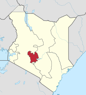 Location in Kenya | |
| Coordinates: 0°45′S 37°0′E / 0.750°S 37.000°ECoordinates: 0°45′S 37°0′E / 0.750°S 37.000°E | |
| Country |
|
| No. of Counties: | 5 |
| Capital | Nyeri |
| Area | |
| • Total | 11,449.1 km2 (4,420.5 sq mi) |
| Population (2009) | |
| • Total | 4,383,743 |
| • Density | 380/km2 (990/sq mi) |
| Time zone | UTC+3 (EAT) |
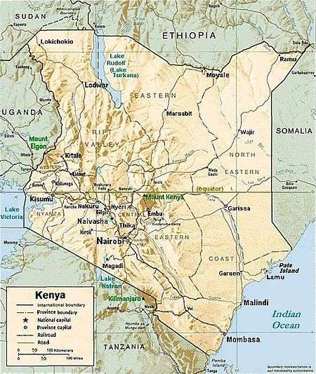
The Central Province (Swahili: Kati) is a region in central Kenya. It covers an area of 13,191 km² and is located to north of Nairobi and west of Mt. Kenya (see maps). The province had 4,383,743[1] inhabitants according to the 2009 census. The provincial capital is Nyeri.
Central Province is the ancestral home of the Gikuyu community.
Climate
The climate of Central Province is generally cooler than that of the rest of Kenya, due to the region's higher altitude. Rainfall is fairly reliable, falling in two seasons, one from early March to May (the long rains) and a second during October and November (the short rains).
General information
Central Province is a key producer of coffee, one of Kenya's key exports. Much of Kenya's dairy industry is also based in this province. The province's headquarters are in Nyeri. Central Province was divided into seven districts (wilaya'at) until 2007:[2]
| District | Population | Capital |
|---|---|---|
| Nyandarua | 479,902 | Ol Kalou* |
| Nyeri | 661,156 | Nyeri |
| Kirinyaga | 457,105 | Kerugoya |
| Maragua | 387,969 | Maragua |
| Murang'a | 348,304 | Murang'a |
| Thika | 645,713 | Thika |
| Kiambu | 744,010 | Kiambu |
| * former capital: Nyahururu | ||
Counties
| Code | County | Former Province | Area (km2) | Population Census 2009 | Capital |
|---|---|---|---|---|---|
| 18 | Nyandarua | Central | 3,107.7 | 596,268 | Ol Kalou |
| 19 | Nyeri | Central | 2,361.0 | 693,558 | Nyeri |
| 20 | Kirinyaga | Central | 1,205.4 | 528,054 | Kerugoya / Kutus |
| 21 | Murang'a | Central | 2,325.8 | 942,581 | Murang'a |
| 22 | Kiambu | Central | 2,449.2 | 1,623,282 | Kiambu |
| Totals | 11,449.1 | 4,383,743 | - |
Districts after 2007
Several new districts (declared sub-counties in 2013) were created in 2007:[2]
| District | Capital |
|---|---|
| Gatanga | Gatanga |
| Gatundu | Gatundu |
| Gatundu North | Kamwangi |
| Githunguri | Githunguri |
| Kabete | Kikuyu |
| Kandara | Kandara |
| Kiambu East (Kiambaa) | Kiambu |
| Kiambu West | Limuru |
| Kieni East | Chaka |
| Kieni West | Mweiga |
| Kigumo | Kigumo |
| Kinangop | Engineer |
| Kirinyaga Central | Kerugoya |
| Kirinyaga East | Kianyaga |
| Kirinyaga South | Wanguru |
| Kirinyaga West | Baricho |
| Lari | Lari |
| Maragua | Maragua |
| Mathioya | Kiria-ini |
| Mathira East | Karatina |
| Mathira West | Kaiyaba |
| Mirangini | Mirangini |
| Mukurweini | Mukurweini |
| Murang'a North | Murang'a |
| Murang'a South | Kenol |
| Nyandarua Central | Ol Kalou |
| Nyandarua North | Ndaragwa |
| Nyandarua South | Njambini |
| Nyandarua West | Ol Jororok |
| Nyeri Central | Nyeri |
| Nyeri South | Othaya |
| Ruiru | Ruiru |
| Tetu | Wamagana |
| Thika East | Gatuanyaga |
| Thika West | Thika |
History
The province is inhabited by the Kikuyu speaking community almost exclusively. They are part of the Kenya Eastern Bantu.
During Kenya's colonization by the British, much of the province was regarded as part of the 'White Highlands', for the exclusive use of the European community. Therefore, it saw political activity from the local communities who felt that they had an ancestral right to the land. This tension culminated in the 1950s with the Mau Mau rebellion; it saw the region placed under a state of emergency and the arrest of many prominent political leaders.
Villages and settlements (A-J)
- Barigito
- Benvar Farm
- Birithia
- Ceronge
- Chegeini
- Chehe
- Cheronge
- Coryndon Farm
- Dhika
- Dondueni
- Ekaru
- Gacaraigu
- Gacharageini
- Gachatha
- Gachege
- Gachichi
- Gachika
- Gachirero
- Gachocho
- Gachoiri
- Gachugi
- Gachuku
- Gacogu
- Gaichanjiro
- Giakaibii
- Gaikundo
- Gaitega
- Gaithece
- Gakanga
- Gakoe
- Gakoi
- Gakuo
- Gakurue
- Gakurwe
- Gakuyu
- Gatakani
- Gatamayu
- Gatangara
- Gategi
- Gatei
- Gateiguru
- Gathagi
- Gathairu
- Gathaithi
- Gathambi
- Gathanje
- Gathehu
- Gathera
- Gathiga
- Gathigio
- Gathigiriri
- Gathima
- Gathinga
- Gathinja
- Gathithina
- Gathuga
- Gathukiini
- Gathumbi
- Gathundia
- Gathungururu
- Gathuthuma
- Gatiabai
- Gatiani
- Gatiguru
- Gatissa
- Gatithi
- Gatuanibu
- Gatugi
- Gatukuyu
- Gatumbi
- Gatumbiru
- Gatunguru
- Gatura
- Gaturiri
- Gatuto
- Gatuya
- Gatwamba
- Gatwe
- Giathenge
- Gichuru
- Gathalni Farm
- Geitwa
- Gekandu
- Gekondi
- Giachamwengi
- Giachumi
- Giagithu
- Giagatika
- Giaitu
- Giakibii
- Gichagiini
- Gicharani
- Gicheru
- Gichiengo
- Gichira
- Gichocho
- Gichongo
- Gichoto
- Gihigaini
- Gikambura
- Gikaru
- Gikigie
- Gikomora
- Gikunguru
- Gikure
- Gikuu
- Gitathi-ini
- Gitembe
- Gitero
- Githagara
- Githagoya
- Githakwa
- Githamba
- Githambo
- Githanga
- Githerere
- Githerioni
- Githima
- Githioro
- Githoito
- Githiru
- Githugi
- Githumu
- Githunguru
- Githuri
- Gitura
- Githuva
- Gitige
- Gititu
- Gituge
- Gitugu
- Gitumbi
- Gitwamba
- Gitweku
- God's Hill
- Greystone Farm
- Heni Village
- Hithe
- Holmwood Farm
- Huguini
- Huhoini
- Icagiciru
- Ichachiri
- Igikiro
- Ihigaini
- Ihinga
- Ihururu
- Ihua
- Ihuririo
- Ildarakwa
- Ihwagi
- Ikumbi
- Iregi
- Iriguini
- Itaga
- Ithaithi
- Ithanji
- Ithanji
- Ithanji
- Ithekahuno
- Ithenguri
- Itheru
- Ithirameru
- Itiati
- Itundu
- Ituru
- Jeure
Villages and settlements (K)
- Kaagogi
- Kabage
- Kabaru
- Kabebero
- Kabochu
- Kabonge
- Kabuku
- Kabuti
- Kagaa
- Kaganda
- Kagarii
- Kagarumo
- Kagere
- Kagia Farm
- Kagicha
- Kagioini
- Kagira
- Kagondo
- Kagondu
- Kagongo
- Kagonye
- Kagumaini
- Kagundo
- Kagwathi
- Kagwongo
- Kahaini
- Kaharati
- Kaharo
- Kahiga
- Kahigaini
- Kahithe
- Kahuho
- Kahunguini
- Kahuro
- Kiangararu
- Kairuthi
- Kaitheri
- Kajinga
- Kamando
- Kamandura
- Kamathuri
- Kamatu
- Kambaa
- Kamberua
- Kameichiri
- Kamondo
- Kampi ya Njemi
- Kamuchege
- Kamuchoni
- Kamuguga
- Kamukabi
- Kamunyaka
- Kamunyuini
- Kamwenja
- Kandegenye
- Kangunyi
- Kangure
- Kanjai
- Kanjora
- Kanvenyeni
- Kanyinya
- Kanyongo
- Kariguini
- Kariko
- Karinga
- Karingaini
- Karirau
- Kariru
- Kariuwa
- Karugutu
- Karugya
- Karunga
- Karura Kanyungu
- Karuris
- Karuruma
- Karweti
- Kathukeni
- Kenyatta Farm
- Keringele
- Kerundu
- Keruri
- Khirgil
- Kiamathambo
- Kiamuchege
- Kiamuthambi
- Kiamwathi
- Kiamwenji
- Kiamworia
- Kiandongoro
- Kiandu
- Kiandumu
- Kiangai
- Kianjege
- Kianjogu
- Kiarakongo
- Kiawambogo
- Kiawamurathe
- Kibiriraini
- Kilimaini
- Kirimunge
- Kimondo
- Kiriangoro
- Kirimaini
- Kirimamwaro
- Kiroe
- Kirigo
- Kiriko
- Kirong'e
- Kirogo
- Kirundu
- Kiuria
- Kiuu
- Kiwegu
- Koimbi
- Komo Farm
- Kuhora Twana
Villages and settlements (L-Z)
References
- ↑ "Kenya Census 2009" (PDF). Kenya Bureau of Statistics. August 28, 2009. Archived from the original (PDF) on August 10, 2013. Retrieved May 22, 2011.
- 1 2 Ministry of State for Provincial Administration and National Security Archived 2009-03-05 at the Wayback Machine.