Upper Palatine Forest
| Upper Palatinate Forest | |
|---|---|
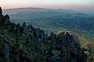
_-_typical_landscape.jpg) View to Mt. Velký Zvon | |
| Highest point | |
| Peak | Čerchov (Schwarzkopf) |
| Elevation | 3,419 ft (1,042 m) |
| Geography | |
 Mountain ranges in the Bavarian-Thuringian-Saxon-Bohemian border region
| |
| Countries | Germany and Czech Republic |
| States/Provinces | Bavaria and Bohemia |
| Parent range |
Central Uplands Bohemian Massif |
| Geology | |
| Orogeny | Variscan |
| Type of rock | Metamorphic Gneiss, Granite and Serpentinite rocks |
The Upper Palatine Forest (German: Oberpfälzer Wald ![]()
Geography
The German side belongs to the Upper Palatinate region of Bavaria, it stretches about 100 km (330,000 ft) from the Bavarian Forest in the south up to the Fichtel Mountains and the Steinwald range in the north. However, the highest peaks of the range lie along the eastern Czech side in the Plzeň Region of western Bohemia, northwest of the Bohemian Forest. The southern rim runs from the Cham and Furth Basin across the border to the Všeruby (Neumark) mountain pass, which is part of the Main European Watershed. The other end is marked by Waldsassen, the northernmost town of the Upper Palatinate.
The Mittelgebirge range is a mountainous solid mass, its highest point being at an altitude of 1,042 m (3,419 ft). Prominent rocks include the Wolfenstein and the Parkstein hill. Once a mining area for iron and gold, the uplands feature many steep valleys, medieval castle ruins and numerous hiking trails. It is a popular destination for recreation.
Rivers rising in the Upper Palatinate Forest include
- Wondreb (Odrava), a tributary of the Ohře (Eger), with Muglbach waterfall
- the Waldnaab headstream of the Naab (Nába) and its Pfreimd and Schwarzach tributaries
- the Mže (Mies) – headstream of the Berounka – and its Hammerbach (Hamerský potok) tributary.
Highest peaks
| German name | Czech name | Height (m) | Height (ft) | State/Region | Country |
|---|---|---|---|---|---|
| Schwarzkopf | Čerchov | 1,042 | 3,419 | Plzeň | Czech Republic |
| Skalka | 1,005 | 3,297 | Plzeň | Czech Republic | |
| Langenfels | Dlouhá skála | 969 | 3,179 | Plzeň | Czech Republic |
| Tillenberg | Dyleň | 939 | 3,081 | Karlovy Vary | Czech Republic |
| Fichtenfels | Smrčí | 935 | 3,068 | Plzeň | Czech Republic |
| Entenbühl | 901 | 2,956 | Bavaria | Germany | |
| Weingartenfels | 896 | 2,940 | Bavaria | Germany | |
| Großer Rabenberg | Havran | 894 | 2,933 | Plzeň | Czech Republic |
| Signalberg | 888 | 2,913 | Bavaria | Germany | |
| Reichenstein | 874 | 2,867 | Bavaria | Germany | |
| Plattenberg | Velký Zvon | 856 | 2,808 | Plzeň | Czech Republic |
| Frauenstein | 835 | 2,740 | Bavaria | Germany | |
| Schellenberg | 829 | 2,720 | Bavaria | Germany | |
| Stückstein | 808 | 2,651 | Bavaria | Germany | |
| Steinberg | 802 | 2,631 | Bavaria | Germany | |
| Fahrenberg | 801 | 2,628 | Bavaria | Germany | |
| Schwarzwihrberg / Schloßberg | 706 | 2,316 | Bavaria | Germany | |
| Johannisberg | 605 | 1,985 | Bavaria | Germany |
Towns and municipalities
Towns
|
|
|
Municipalities
External links
- www.oberpfaelzerwald.de - Oberpfälzerwald.de (in German) (also available in English)
- www.oberpfaelzer-waldverein.de - Upper Palatine Forest Club (in German)
- www.heimat-now.de - Information about the Schellenberg Ruins (in German)
- www.bocklradweg.de - Cycling the od railway routes and info about the Upper Palatine Forest (in German)
Coordinates: 49°23′00″N 12°47′01″E / 49.38333°N 12.78361°E
| Authority control |
|---|
.jpg)