Waidhaus
| Waidhaus | ||
|---|---|---|
| ||
 Waidhaus Location of Waidhaus within Neustadt a.d.Waldnaab district 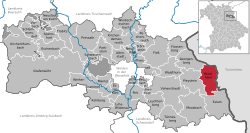 | ||
| Coordinates: 49°38′30″N 12°29′40″E / 49.64167°N 12.49444°ECoordinates: 49°38′30″N 12°29′40″E / 49.64167°N 12.49444°E | ||
| Country | Germany | |
| State | Bavaria | |
| Admin. region | Oberpfalz | |
| District | Neustadt a.d.Waldnaab | |
| Government | ||
| • Mayor | Anton Schwarzmeier | |
| Area | ||
| • Total | 37.00 km2 (14.29 sq mi) | |
| Elevation | 524 m (1,719 ft) | |
| Population (2017-12-31)[1] | ||
| • Total | 2,199 | |
| • Density | 59/km2 (150/sq mi) | |
| Time zone | CET/CEST (UTC+1/+2) | |
| Postal codes | 92726 | |
| Dialling codes | 09652 | |
| Vehicle registration | NEW | |
| Website | www.waidhaus.de | |

Waidhaus is a municipality in the district of Neustadt in Bavaria in Germany. It lies near the border with the Czech Republic, and near the major border crossing between Bavaria and the Czech Republic, where the Bavarian A6 meets the Czech D5 motorway. The closest towns are on the German side Pleystein and on the Czech side Rozvadov. A gas pipeline and a powerline also cross the border between Bavaria and the Czech Republic there.
Neighbouring communities
The neighbouring communities clockwise: Rozvadov, Eslarn, Pleystein, Georgenberg.
Places adjacent to Waidhaus | |
|---|---|

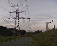
380 kV-powerline crossing the national border between Bavaria and Czech near Waidhaus. The pylon in the foreground stands in Bavaria the others are in the Czech Republic
References
- ↑ "Fortschreibung des Bevölkerungsstandes". Bayerisches Landesamt für Statistik und Datenverarbeitung (in German). September 2018.
This article is issued from
Wikipedia.
The text is licensed under Creative Commons - Attribution - Sharealike.
Additional terms may apply for the media files.