Korab (mountain)
| Mount Korab | |
|---|---|
 | |
| Highest point | |
| Elevation | 2,764 m (9,068 ft) [1] |
| Prominence | 2,169 m (7,116 ft) [1] |
| Listing |
Country high point Ultra |
| Coordinates | 41°47′28″N 20°32′52″E / 41.79111°N 20.54778°ECoordinates: 41°47′28″N 20°32′52″E / 41.79111°N 20.54778°E [1] |
| Geography | |
 Mount Korab Location of Korab | |
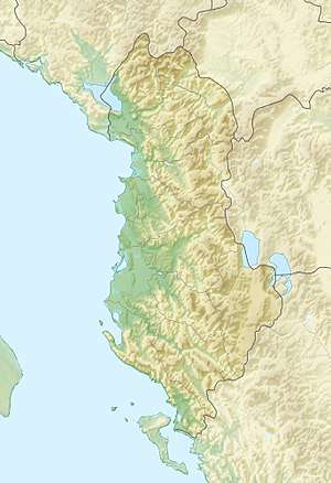
| Location | Albania—Republic of Macedonia border |
| Parent range | Korab |
Mount Korab (Albanian: Maja e Korabit or Mali i Korabit; Macedonian: Голем Кораб, Golem Korab) is the highest peak of the eponymous fourth highest mountain in the entire Balkan Peninsula, standing at 2,764 metres (9,068 ft).
The summit of the Korab mountain range in the Albanian-Macedonian border, Korab is the highest peak of Albania and the Republic of Macedonia and also one of only two summits in Europe, which are the highest point for more than one country.[2] The Korab is also the 18th most prominent mountain peak in the European continent.[3]
Korab is situated within the Korab-Koritnik Nature Park.[4][5] It is noted for its rich flora, including species such as Bosnian pine, European beech, Coppicing forest, and Alder forest.[6]
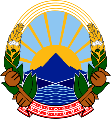
The peak lies adjacent to the Šar Mountains. Mount Korab is also pictured in the coat of arms of the Republic of Macedonia.
Geography
The Korab range stretches over 40 kilometres (25 mi) in a north-south direction between the lower section of the Black Drin and its tributary Radika. It is located around the border triangle of Albania, Macedonia and Kosovo, southwest of the Šar Mountains.
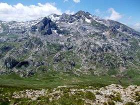
The peak is a very rugged mountain massif and consists mainly of shale and limestone of the Paleozoic period with block structures, as well as severely damaged gypsum rocks of Permo Triassic. On the west side, the mountain falls steeply over rock walls. The north side consists of craggy rocks. A kind of double peak, that of Korab II 2,756 metres (9,042 ft) is about 150 metres (490 ft) northwest of the peak within Albanian territory. On the same ridge are two other peaks rising over 2,700 metres (8,900 ft) such as Shulani i Radomires and Korab III. The southeast, stretching from a few rock bands broken meadows to the summit is accessed by very simply, and occasionally by shepherds with their flocks of sheep.
In addition to the Korab peak, there are several other, almost equally high elevations. North of the twin peaks are numerous other nameless, almost equally high rock towers. The peak located about 2 kilometres (1.2 mi) southwest, Korab-gate (Albanian: Maja e Portës së Korabit; Macedonian: Korapska Mala vrata) reaches 2,727 metres (8,947 ft). A few hundred yards south is another peak Maja e Moravës, which is only a little lower at 2,718 metres (8,917 ft).
The peaks are occasionally ruptured by radial tectonics in the shape of blocks that end in the Radika Valley on the Republic of Macedonian side. These blocks occasionally have steep slopes that reach up to 500 m (1,640 ft). In its highest part, above 2,000 m (6,562 ft), the climate is alpine and includes some alpine flora elements. The mountain is home to spectacular Korab Falls in the upper valley of the Dlaboka River. During spring time, the waterfall reaches a height of over 130 meters, which makes it the highest in Macedonia. The state border intersects the higher peak, Great Korab.
Ascent from the Macedonian side involves entering the Republic of Macedonian-Albanian boundary area, for which a special permit is required from the Ministry of Internal Affairs of the Republic of Macedonia,[7] although people regularly track on Korab without it.
The two main passes in the Korab ridge include the Little Korab Gate 2,465 m (8,087 ft) and Big Korab Gate 2,062 m (6,765 ft).
The mountain has a number of sub-peaks that are higher than 2000 metres. These include Korab II (unnamed peak) 2,756 m (9,042 ft), Korab III (unnamed peak) 2,724 m (8,937 ft), Korab Gates (peak) 2,727 m (8,947 ft), Maja e Moravës 2,718 m (8,917 ft), Shulani i Radomirës 2,716 m (8,911 ft) and Small Korab 2,683 m (8,802 ft).
Climbing
There are no formal restrictions on climbing the mountain from the Albanian side. The area is now safer and more stable than it has been in recent times. It is possible to drive as far as the local village of Radomira, but the local infrastructure is generally not good. A four-wheel drive vehicle with high clearance may be required. There are no accurate and up to date maps, local signposting is poor, and hikers may have to overcome the additional problem of aggressive dogs.[8] An international expedition to climb Mount Korab is organized each September by the mountain club PSD "Korab" in Skopje.
See also
| Wikimedia Commons has media related to Mount Korab. |
References
- 1 2 3 "Europe Ultra-Prominences". Peaklist.org. Retrieved 2013-02-16.
- ↑ "The King of the Mountains" (PDF). dmwcorg.tk. p. 24.
At 2764 meters Korab peak is one of only two summits in Europe which are the highest point for more than one country.
- ↑ "EUROPE ULTRA-PROMINENCES 99 Peaks with Prominence of 1,500 meters or greater". peaklist.org.
- ↑ "Korab-Koritnik Nature Park". akzm.gov.al.
- ↑ "Adventure tourism at the Natural Park of Korab and Jezina cave". ata.gov.al. Retrieved 25 August 2015.
Jezina Cave is one of the treasures of the Korab-Koritnik Natural Park. It is located on the south-western part of Kërcula Peak up 850 m above sea level.
- ↑ "Korab - Koritnik Natural Park Management Plan". researchgate.net. p. 13.
Most of these areas are dominated by Bosnian pine (Pinus heldreichii) and European Beech (Fagus sylvatica).: - The sustainable zone includes Oak (Quercus) wood land, coppiced oak forest, beech (Fagus) forest and beech coppice, Alder (Alnus) forest along streams, rocky areas with little vegetation and extensive production of walnuts and chestnut.
- ↑ Mount Korab on SummitPost
- ↑ 2007 Trip Report