Jiehkkevárri
| Jiehkkevárri | |
|---|---|
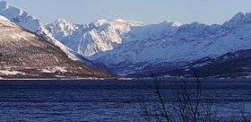 Jiekkevarre with its glacier towering over the ice-free Balsfjord. February 2009. | |
| Highest point | |
| Elevation | 1,834 m (6,017 ft) [1][2] |
| Prominence |
1,741 m (5,712 ft) [1][3] 2nd in Norway |
| Isolation | 158 kilometres (98 mi) |
| Listing | Ultra |
| Coordinates | 69°28′09″N 19°52′39″E / 69.4693°N 19.8776°ECoordinates: 69°28′09″N 19°52′39″E / 69.4693°N 19.8776°E [4] |
| Geography | |
 Jiehkkevárri Location of the mountain  Jiehkkevárri Jiehkkevárri (Norway) | |
| Location | Troms, Norway |
| Parent range | Lyngen Alps |
| Topo map | 1633 IV Storfjord |
| Climbing | |
| First ascent | 1899 |
| Easiest route | Skiing |
Jiehkkevárri (alternate spellings: Jiekkevarri, Jiekkevarre, or Jæggevarre) is a mountain on the border of the municipalities of Lyngen and Tromsø in Troms county, Norway. It is the highest mountain in Troms county and has the second highest prominence (primary factor) among Norwegian mountains. The 1,834-metre (6,017 ft) tall mountain sits about 10 kilometres (6.2 mi) northeast of the village of Lakselvbukt and about 17 kilometres (11 mi) southwest of the village of Lyngseidet.
The first people known to have climbed it were Geoffrey Hastings (British) and Elias Hogrenning (Norwegian) in 1899. Its summit is ice-capped and any ascent involves a crossing of crevassed glaciers. Therefore, climbing it needs guiding by experienced mountaineers.[5][6]
In winter, an experienced ski-mountaineer can traverse Jiehkkevárri in one long day, descending almost from the top via the steep, northeast facing couloir, described by the late Andreas Fransson as "a future classic for the new generation of mountain skiers".[7] The descent route is exposed to serac fall from above, and is generally not recommended for ascending.
Name
The name is a compound of the Sami language words jiehkki which means "glacier" and várri which means "mountain".
See also
References
- 1 2 "Europe Ultra-Prominences" Peaklist.org. Retrieved 2012-03-31.
- ↑ "Jiehkkevárri". yr.no.
- ↑ The key col is at 69°12′N 19°45′E / 69.200°N 19.750°E and the parent peak is Kebnekaise
- ↑ "Jiehkkevárri, Tromsø (Troms)" (in Norwegian). yr.no. Retrieved 2018-08-07.
- ↑ Dyer, Anthony; Robertson, I.H.; Baddeley, J.M. (2006). Walks and Scrambles in Norway. Rockbuy Limited. ISBN 978-1-904466-25-3.
- ↑ Bjørstad, Petter E. "Petter Bjørstad's mountain page".
- ↑ Fransson, Andreas. "Andreas Fransson's blog report on Jiehkkevárri traverse, with descent via NE Couloir".