Highways in Albania
The Highways in Albania are the central state and main transport network in Albania. The motorways and expressways are both part of the national road network. The motorways are primary roads with a speed limit of 110 kilometres per hour (68 mph).[1] They have white on green road signs such as in Italy and other countries nearby. The expressways are the secondary roads, also dual carriageways, but without an emergency lane. They have a speed limit of 90 kilometres per hour (56 mph). They have white on blue road signs.[1]
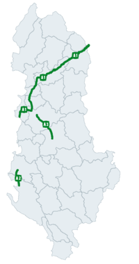
The A1 is the country's longest and only toll highway connecting the port city of Durrës on the Adriatic Sea in the west as well as the capital of Tirana in the center, with the country of Kosovo in the northeast. The A3 is the second longest motorway and connects Tirana with the Pan-European Corridor VIII, running from Durrës on the Adriatic Sea to Varna on the Black Sea. The A2 is the third longest motorway and represent a significant north-south corridor within the country and the Adriatic-Ionian motorway.
History
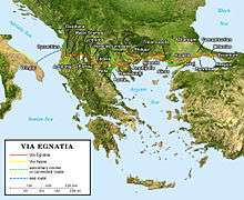
Since antiquity, the area of Albania served as an important crossroad within the Roman Empire through the Via Pubblica and Via Egnatia. The former passed through northern Albania, while the latter linked Rome with Byzantium, through Durres on the Adriatic Sea. During World War I, occupying forces opened up new road sections mainly in the mountainous areas of the country. In King Zog's period, further road construction took place near Vlora and at Krraba Pass between Tirana and Elbasan.
The total length of Albania's roads more than doubled in the first three decades after World War II, and by the 1980s almost all of the country's remote mountain areas were connected, either by dirt or paved roads, with the capital city of Tirana, and ports on the Adriatic and Ionian Sea. Private car ownership was not allowed and the only vehicles circulating were state-owned trucks, agricultural and official's vehicles, buses, motorcycles, and bicycles. The country's roads, however, were generally narrow, poorly marked, pocked with holes, and in the early 1990s often crowded with pedestrians and people riding mules, bicycles, and horse-drawn carts.
The largest road project in the history of Albania was the construction of the A1 dual carriageway from 2007 to 2010, linking Albania with Kosovo. The segment involved the carving of a mountainous terrain, and the construction of a 5.6 km long tunnel and dozens of bridges.[2] In 2010, Prime Minister Sali Berisha announced plans to build several major highways.[3]
At present, major cities are linked with either single or dual carriageways or well maintained roads. There is a dual carriageway connecting the port city of Durrës with Tirana, Vlorë, and partially Kukës. In fact, there are three formal motorway segments in Albania: Thumanë-Milot-Rrëshen-Kalimash (A1), Levan-Vlorë (A2), and partly Tirane-Elbasan (A3). Most rural segments continue to remain in bad conditions as their reconstruction has only began in the late 2000s by the Albanian Development Fund.[4]
Road system
All roads in the country are property of Albanian Road Authority (Autoriteti Rrugor Shqiptar (ARRSH)), a directorate subordinated to the Ministry of Transportation and Infrastructure based in Tirana. Currently, cars are free of payment while driving on both motorways and expressways except on A1 motorway which has become a toll highway since March 2018. A2 and A3 are planned to become toll highways in the near future. A new road system has been introduced in the early 2000s and is classified as follows[5]:
| Type | Name (Albanian) | Name (English) | Description |
|---|---|---|---|
| Autostrada | Motorway | The motorways are the highest level of roadway in the country, marked as A with a number on a green field. | |
| Rrugë Shtetërore | State Road | The state roads are the main and most common level of roadway in the country, connecting major cities marked as SH with a number on a blue field. | |
| Rrugë Rrethi | District Road | The district roads are the lower level of roadway in the country found between districts roadway marked as Rr with a number on a blue field. | |
| Rrugë Komunale | Municipal Road | The municipal roads are the owest level of roadway in the country, typically found in rural areas and marked as K with a number on a white field though it is not observed on the ground. | |
Motorways
The motorways in Albania are defined by the Ministry of Transportation and Infrastructure. The country's motorway network has been extensively modernised throughout the end of the communist regime and part of it is still under construction. In Albanian, they are called Autostrada or Autostradë and they are defined as roads with at least two lanes in each direction.[6][7] The markings has green background and are identified as consisting of letter A and the motorway number assigned by the legislation. The national speed limit on an autstrada, effective in case no other speed limits are present, is 110 kilometres per hour (68 mph).[8]
| Motorway | County | Length | Description | Cities |
|---|---|---|---|---|
| Durrës, Tirana, Lezhë and Kukës | 115 km (71 mi) | The A1 (Albanian: Autostrada A1) is a four traffic lane motorway, spanning 115 km (71 mi).[9] The motorway connects the economic centres of Albania including Durrës and Tirana with Kosovo. | Durrës, Laç, Lezhë, Rrëshen and Kukës | |
| Fier and Vlorë | 46.5 km (28.9 mi) | The A2 (Albanian: Autostrada A2) is a four traffic lane motorway, spanning 46.5 km (28.9 mi). It represent a major north–south corridor and as well as a significant section of the Adriatic–Ionian motorway. | Fier and Vlorë | |
| Tirana, Elbasan, Berat and Gjirokastër | 110 km (68 mi) | The A3 (Albanian: Autostrada A3) is a four traffic lane motorway, spanning 110 km (68 mi). After its completion, the motorway will connect Tirana, the country's capital, with the Pan-European Corridor VIII. Further, 31 km (19 mi) are currently under construction, while 79 km (49 mi) are planned. | Tirana and Elbasan |
Expressways
| Motorway | County | Length | Description | Cities |
|---|---|---|---|---|
| Shkodër, Lezhë, Durrës and Tirana | 125 km (78 mi) | The SH1 starts on the border of Montenegro near Han i Hotit and proceeds southeast towards Shkodër. It continues south to Lezhë through to Tirana. The route contains junctions with the SH2 expressway and A1 motorway. It represent a major north-south corridor, which forms a significant section of the Adriatic-Ionian motorway. | Shkodër, Lezhë, Fushë-Krujë and Tirana | |
| Durrës and Tirana | 33 km (21 mi) | Durrës and Tirana | ||
| Tirana, Elbasan and Korçë | 151 km (94 mi) | Tirana, Librazhd, Lin, Pogradec, Korçë, Devoll and Bilisht | ||
| Durrës, Tirana, Fier and Gjirokastër | 215 km (134 mi) | Durrës, Fier, Gjirokastër and Kakavijë | ||
| Shkodër and Kukës | 0 km (0 mi) | Shkodër, Pukë, Kukës and Morinë | ||
| Lezhë and Dibër | 0 km (0 mi) | Elbasan, Klos and Maqellarë | ||
| Tirana and Elbasan | 40.5 km (25.2 mi) | Rrogozhina and Elbasan | ||
| Fier and Vlorë | 126 km (78 mi) | Fier, Vlorë and Sarandë | ||
| Elbasan | 3.2 km (2.0 mi) | Qafë Thanë |
Under construction
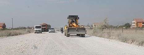
Following the end of communism in 1991, the highways in the country began to be modernized with the construction of the National Road 2, connecting the country's capital of Tiranë with the country's second largest city of Durrës. Since 2000, main roadways have drastically improved, though lacking standards in design and road safety.[10][11] This involved the construction of new roadways, planting of trees and related greening projects, and lately the installing of contemporary signs. However, some state roads continue to deteriorate from lack of maintenance while others remain unfinished.
The priority of the first Rama government in 2014 was the completion of unfinished roadways, due to lack of funding. Another major priority was the completion of the Arbër Highway (Rruga e Arbërit), connecting Tirana with the city of Debar in the Republic of Macedonia through the current National Road 6. Eventually, this Superstradë will become part of the Pan-European Corridor VIII, linking Albania with the Republic of Macedonia and Greece.[12] Another important objectives include, the completion of the problematic Tirana-Elbasan Highway part of the A3, the launching of toll highways starting with A1, and the construction of the Southern Axis of Albania Boshti i Jugut, passing across central and southern Albania. The completion of the Eastern Ring of Albania Unaza Lindore passing through Valbonë, Kukës, Krumë, Bulqizë and Librazhd has also been a priority. When all corridors are completed, Albania will have an estimated 759 kilometers of highway linking it with its neighbors.
Despite considerable investments, some dual carriageways are partially up to either motorway or state road standards as they are badly configured, contain unfinished overpasses, uncontrolled access points, lack of fencing and either misplaced or missing road signs, inadequate entry and exit ramps, and are indiscriminately used by animals, mopeds, agricultural vehicles, and pedestrians. These are mostly due to alleged corruption and lack of or low quality projects and feasibility studies.
Works on most highways are mostly completed, though they remained unfinished between 2011 and 2013 as per lack of funds.
Below is a list of main roadways undergoing construction works in the last decade. The Rama 2 Government plans to standardize road projects and continue those left unfinished from previous years.
As of Summer 2018
.jpg)

Planned


- Shengjin-Velipoje
- SH8 Llogora Tunnel
Underway


- SH4 Tepelena Bypass
- SH76, SH77 Vlora River Highway (Vlorë - Kuç - Qeparo)
- SH61, SH6 Tiranë- Brar Canyon - Bulqize, part of Arbër Highway: Superstradë

- SH21 Boge - Theth
- SH27 Shkodër - Velipoje
- Berat - Elbasan: Superstradë
- SH3 Qukës - Qafë Plloçë: Rrugë
- Kardhiq - Delvine
Completed

- Tirana Southwestern and Southeastern Outer Ring: Autostradë


- SH20 Hani Hotit - Tamarë - Vermosh - Dogana MNE
- SH21 Koplik - Dedaj - Bogë: Rrugë
- SH22 Fierzë - Bajram Curri
- SH22 Bajram Curri - Tropojë: Superstradë
- K22 Valbonë - Dragobi - Bajram Curri
- SH38 Fushë Krujë - Krujë: Superstradë
- SH42 Dedaj - Razëm: Rrugë
- SH72 Lushnje - Berat
- SH81 Sarandë - Butrint: Superstradë
- Ura e Kardhiqit - Sarandë: Rrugë
- Sarandë - Qafë Botë GR: Superstradë
- Bajram Curri - Margegaj: Superstradë
- Most coastal roads
- Other rural segments
Driving in Albania

Despite the perceived negative connotation to driving in Albania, most vehicles manage not to get into accidents by simply exercising common sense and following their own way through the traffic. In cities, traffic is slow thus more secure than in rural areas. Albanian drivers are prone to using visual and acoustic aids regularly such as honking, headlight flashing, or high beams at night. Daytime running lamps must be activated outside urban areas.
It is strongly recommended to have an up-to-date GPS, as many new roads have been recently added to the Albanian road network. If the GPS does not work, a paper or internet-based map would be useful. Street names on the ground do not always coincide with maps as the current address system has been recently introduced. In the mountains, some roads can be narrow and windy with hairpins, unpaved, and missing guardrails. A portion of these roads are being gradually paved and brought to European standards by the Albanian Development Fund, FSHZH. Other roads still have few road signs or misleading ones. Its strongly advised to always keep a spare tire.
International routes

Albania is part of the Pan-European Corridor program, with Pan-European Corridor VIII going through the country. It takes the following route: ![]()
![]()
![]()
![]()
![]()
Albania acceded the European Agreement on Main International Traffic Arteries in 2006.[15] However, neither Albania, nor the UNECE, have listed any routes inside the country. The following E Roads are currently defined to end at, or near, the border of Albania.
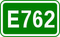
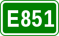
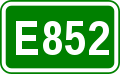

It is conjectured that these E Roads take the following routes in Albania
See also
| Wikimedia Commons has media related to Highways in Albania. |
References
- 1 2 "KODI RRUGOR I REPUBLIKËS SË SHQIPËRISË" (PDF). pp.gov.al (in Albanian). Tirana. p. 76.
- ↑ "Albanian Motorway Cuts Travel Time & Boosts Trade - Bechtel". Bechtel. 3 March 2016.
- ↑ "Business: Albania to focus on new roads (SETimes.com)". 2010-10-15. Retrieved 2010-10-16.
- ↑ "Fondi Shqiptar i Zhvillimit".
- ↑ "SINJALET E INDIFIKIMIT TE RRUGES" (PDF). dpshtrr.gov.al (in Albanian). Tirana.
- ↑ Ministry of Transportation and Infrastructure. "PYETËSOR TEORIK PËR DREJTUESIT E MJETEVE RRUGORE" (PDF). aca.al. p. 2.
- ↑ "KODI RRUGOR I REPUBLIKËS SË SHQIPËRISË" (PDF). pp.gov.al (in Albanian). Tirana. p. 1.
- ↑ "KODI RRUGOR I REPUBLIKËS SË SHQIPËRISË" (PDF). pp.gov.al (in Albanian). Tirana. p. 76.
- ↑ "MILOT – MORINE HIGHWAY PROJECT REQUEST FOR QUALIFICATION" (PDF). businesshungary.gov.hu. p. 8.
- ↑ "Archived copy" (PDF). Archived from the original (PDF) on 2013-05-20. Retrieved 2015-06-19.
- ↑ http://siteresources.worldbank.org/INTALBANIA/Resources/Albania_National_Transport_Plan.pdf
- ↑ "Archived copy" (PDF). Archived from the original (PDF) on 2012-03-27. Retrieved 2012-03-27.
- ↑ http://ec.europa.eu/enlargement/pdf/projects-in-focus/donor-coordination/2-3_april_2009/working_group_transport_seeto_en.pdf
- ↑ http://ec.europa.eu/enlargement/news_corner/news/news-files/150420-joint-statement.pdf
- ↑ UNECE newsletter. "Albania joins E-road agreement" (PDF). UNECE. Retrieved 23 September 2015.