Maja Jezercë
| Maja Jezercë | |
|---|---|
 Maja Jezercë as seen from Maja Trojan | |
| Highest point | |
| Elevation | 2,694 m (8,839 ft) [1] |
| Prominence | 2,036 m (6,680 ft) [2] |
| Listing | Ultra |
| Coordinates | 42°26′33″N 19°48′51″E / 42.44250°N 19.81417°ECoordinates: 42°26′33″N 19°48′51″E / 42.44250°N 19.81417°E [2] |
| Naming | |
| Translation | Lake Peak (Albanian) |
| Geography | |
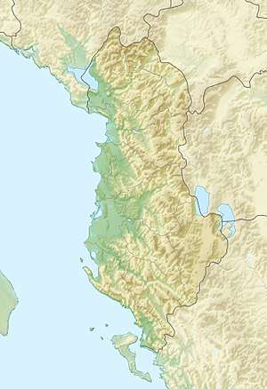 Maja Jezercë Albania | |
| Location | Shkodër County |
| Parent range | Albanian Alps, Dinaric Alps |
| Geology | |
| Mountain type | Limestone |
| Climbing | |
| First ascent | 1929 by Sleeman, Elmslie and Ellwood |
| Easiest route | North slope |
Maja Jezercë (Albanian: Maja Jezercë) is the highest peak in the entire Dinaric Alps, the second highest in Albania and the seventh highest in the Balkans, standing at 2,694 m (8,839 ft) above sea level. It is one of the toughest if not one the most dangerous climbs in the Albanian Alps. However, Maja Jezercë is the 28th most prominent mountain peak in the European continent.[3]
Maja Jezercë is situated within the Albanian Alps, that is noted for its southernmost glaciers in Europe.[4] Apart from certain areas north of the peak, the limestone mountain massif is part of the National Parks of Theth and Valbonë Valley.[5] It can be climbed from the north; most climbers come from Gusinje in Montenegro as well as from Theth.[6]
The summit is 5 km (16,404 ft) from the border with Montenegro, between the Valleys of Valbonë to the east and the Shala to the west. In part, the whole floor between the valley of Valbonë, Shala, Ropojana and Maja Roshit 2,522 m (8,274 ft) is known as Jezercë, in addition to the peak, Jezercës borders other peaks such as the Maja e Popljuces (2,569 metres) and the Maja Ali 2,471 m (8,107 ft) in the west, Maja Rrogamit]] 2,478 m (8,130 ft) to the east, Maja Kolajet 2,498 m (8,196 ft), Maja Malësores 2,490 m (8,169 ft), Maja Bojs 2,461 m (8,074 ft) in the northwest, Maja Kokervhake 2,508 m (8,228 ft) and Maja Etheve 2,393 m (7,851 ft) in the north.
Name
The Maja Jezercë is the Albanian name, which is derived from north dialect of Albania,, probably more specifically from North dialect of Tropoja wikt:jezer, ("Fog"), and Albanian word maja ("top" or "peak"), meaning "peak of Fog". In Slavic languages, including Serbo-Croatian and Bulgarian,[7][8][9][10] Jezerski Vrh means "lake peak". The toponym refers to the cirque lakes in the lower part of the Buni i Jezercës on the northern side of the mountain. During the Communist era in Albania it had been given the name of Maja e Rinisë (Mountain of Youth), which never stuck.[6]
Topology

Jezerca is a large rocky peak of dolomitic limestone. There is almost no vegetation there. North, east and west of the mountain top is in great cirque from that in the glacial periods when glaciers were more extensive than today. Today the northern cirque is called Buni i Jezercës at a height of 1980 metres and 2,100 metres in height around 400 metres. Because it is located in the wettest region of Europe with around 6 metres (240 in) of rainfall equivalent believed to fall on the western slopes, snowfall is so large that only in dry years do even the less exposed sections melt away.[11]
Gallery
_sa_Karanfila_(2480).jpg) The summit seen from the top of Karanfili 2,480 m (8,136 ft).
The summit seen from the top of Karanfili 2,480 m (8,136 ft).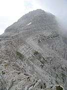 The peak from the north.
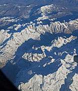 Jezercë in front, Runica valley and Karanfil
.jpg) View from summit Zla Kolata
View from summit Zla Kolata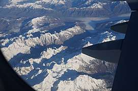 View from the plane over the Albanian Alps
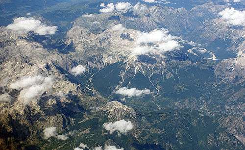 The Jezercë massif from above
See also
References
- ↑ "Maja e Jezercës". Peakbagger.com. Retrieved 2014-05-24.
- 1 2 "Europe Ultra-Prominences". Peaklist.org. Retrieved 2014-05-24.
- ↑ "EUROPE ULTRA-PROMINENCES 99 Peaks with Prominence of 1,500 meters or greater". peaklist.org.
- ↑ "FEASIBILITY STUDY ON ESTABLISHING A TRANSBOUNDARY PROTECTED AREA PROKLETIJE / BJESHKËT E NEMUNA MOUNTAINS" (PDf). condesan.org. p. 4.
The number of glacial ponds in this area is rare for the European mainland and can only be compared to the Alps.
- ↑ Florian Baba (Herausgeber): Linja e Gjelbër Shqiptare, Tirana 2008
- 1 2 "Summipost: Jezerca". Retrieved 2 August 2009.
- ↑ Elezi, Mehmet. "Kush i nemi "Bjeshkët e Nemuna"?". Gazeta55.
- ↑ Kolcakovski, Belj (1997). The periglacial zone of high mountains of Serbia and Macedonia and its basic characteristics. Observatoire de Montagne de Moussala.
- ↑ Втора југословенска ономастичка конференција. Скопје: Македонска академија на науките и уметностите. 1980.
- ↑ Petrović, Mihailo (1941). Đerdapski ribolovi u prošlosti i u sadašnjosti. Zadužbine Mikh. R. Radivojeviča. p. 8.
- ↑ Milivojević, Milovan; Menković, Ljubomir; Ćalić, Jelena (2008), "Pleistocene glacial relief of the central part of Mt. Prokletije (Albanian Alps)", Quaternary International, 190: 112–122, doi:10.1016/j.quaint.2008.04.006