Dešat
| Dešat | |
|---|---|
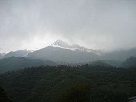 Dešat from Saint Jovan Bigorski Monastery | |
| Highest point | |
| Elevation | 2,375 m (7,792 ft) |
| Coordinates | 41°38′N 20°32′E / 41.63°N 20.54°E |
| Geography | |
| Location | Albania and the Republic of Macedonia |
Dešat or Deshat (Macedonian: Дешат) is a mountain on the border between Albania and the Republic of Macedonia.[1] The mountain is characterised by its steep peaks: Mal and Golem Kërçinë and Velivar. The highest peak on the mountain, Velivar, is situated on 2,375 m (7,792 ft) above the sea level. Other significant peaks are: Deli Senica, and Suva Bara. Dešat also has deep river gorges, immense forests, and small glacial mountain lakes. The nearest town from the Albanian side is Peshkopi and from the Macedonian side is Debar.
References
- ↑ Pandi Geço (1959). Shqipëria: pamje fiziko-ekonomike. Tekst për Fakultetin e histori-filologijsë dhe Fakultetin ekonomik. Mihal Duri. p. 14.
| Wikimedia Commons has media related to Category:Dešat. |
This article is issued from
Wikipedia.
The text is licensed under Creative Commons - Attribution - Sharealike.
Additional terms may apply for the media files.