Korab
| Korab | |
|---|---|
.jpg) Mount Korab | |
| Highest point | |
| Peak | Mount Korab |
| Elevation | 2,751 m (9,026 ft) |
| Prominence | 2,169 metres (7,116 ft) |
| Coordinates | 41°47′25″N 20°32′48″E / 41.79028°N 20.54667°ECoordinates: 41°47′25″N 20°32′48″E / 41.79028°N 20.54667°E |
| Geography | |
| Countries | Albania and Republic of Macedonia |
| Geology | |
| Age of rock | Paleozoic |
| Mountain type | Range |
| Type of rock | Limestone |
Korab (Albanian: Mali i Korabit, Macedonian: Кораб) is a mountain range in the eastern corner of Albania and the western part of the Republic of Macedonia, running along the border between both countries. It forms also the European Green Belt. In Albania, it is also called Vargu lindor (English: Eastern range), but this term encompasses mountains further north, such as the Koritnik and Gjallica. The highest peak is Mount Korab at 2,751 m (9,026 ft) above sea level.[1] With a prominence of 2,169 m (7,116 ft), Korab is the 18th most prominent mountain peak in the European continent.[2] The mountains are composed of sedimentary rock, including shale, sandstone, dolomite and limestone. The name refers to a Paleochristian sea god.
Geographically, the Korab mountain range extendes 40 km (25 mi) from the Dibër Valley in a north-south direction, between the river valleys of the Black Drin and its tributary the Radika. It is located near the tripoint of Albania, Macedonia, and Kosovo, southwest of the Šar Mountains. The Drin Valley lies around 400 m (1,300 ft) to the west, the bed of the Radika at about 1,000 m (3,300 ft) above sea level.
The geology of the park is dominated by mountains made up of exposed faulted sedimentary rock and valleys containing glacial lakes.
The Albanian part has numerous high peaks and ranges, almost as tall as the Korab massif. To the north of this double-peak there are many other nameless peaks of a similar height. Korab-Pforte (Albanian: Maja Portat e Korabit, Macedonian: Mala Korapska Vrata) lies around 2 km (1.2 mi) southwest of Korab massif and is almost as tall as the main mountain, at 2,727 m (8,947 ft). A few hundred meters further south, there are another peaks, Maja e Moravës 2,718 m (8,917 ft) and Mali i Gramës 2,345 m (7,694 ft). The mountains are composed of shale and limestone. Much of the range is protected by nature parks; the Korab-Koritnik Nature Park.[3][4]
South of the complex of peaks around Mount Korab, there are other large mountains: Mali i Gramës (2,345 m (7,694 ft)) and Dešat's Velivar summit (2,375 m (7,792 ft)). After that, the range falls away to the city of Debar and the Debar Lake.[5] The city of Peshkopi is to the southwest of Mali i Gramës and has geothermal baths.
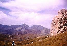 The range from the Macedonian side
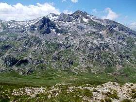 Fusha e Korabit
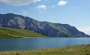 Glacial Gramë Lake
 Dešat
Dešat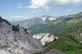 Gypsum near the Mali i Bardhë
See also
| Wikimedia Commons has media related to Mount Korab. |
References
- ↑ "2007 Trip Report".
- ↑ "EUROPE ULTRA-PROMINENCES 99 Peaks with Prominence of 1,500 meters or greater". peaklist.org.
- ↑ "RRJETI I ZONAVE TË MBROJTURA NË SHQIPËRI" (PDF). mjedisi.gov.al (in Albanian). p. 2.
- ↑ "Korab - Koritnik Natural Park Management Plan" (PDF). researchgate.net. July 2014. p. 9.
- ↑ Perikli Qiriazi (2006). Gjeografia fizike e Shqipërisë. Tirana: Shtëpia botuese e librit universitar. p. 189. ISBN 99927-0-397-0.