Mount Olympus (Cyprus)
| Mount Olympus | |
|---|---|
| Chionistra | |
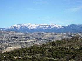 Mount Olympus in Winter | |
| Highest point | |
| Elevation | 1,952 m (6,404 ft) [1] |
| Prominence | 1,952 m (6,404 ft) [2] |
| Listing |
Country high point Ultra |
| Coordinates | 34°56′11″N 32°51′48″E / 34.93639°N 32.86333°ECoordinates: 34°56′11″N 32°51′48″E / 34.93639°N 32.86333°E [3] |
| Geography | |
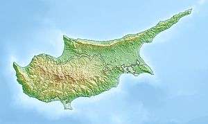 Mount Olympus Location of Mount Olympus in Cyprus | |
| Location | Cyprus |
| Parent range | Troodos |
Olympus, or Chionistra, (Greek: Όλυμπος or Greek: Χιονίστρα) at 1,952 metres (6,404 ft), is the highest point in Cyprus.[3] It is located in the Troodos Mountains of Cyprus.[4] Mount Olympus peak and the "Troodos Square" fall under the territory of Platres in Limassol District. A British long range radar currently operates at Mount Olympus' peak. The Mount Olympus Ski resort consists of the Sun Valley and North Face areas. Each area has its own chairlifts and runs.
Writing in the late first century BC or first century AD, the geographer Strabo reported that on one of its promontories was a temple to Aphrodite of the Heights (Greek: ἀκραία), which women were forbidden to enter.[5]
There are 4 ski slopes:
- Aphrodite or Sun Valley I, Length: 150m, Level: Beginner
- Hermes or Sun Valley II, Length: 150m, Level: Intermediate
- Dias/Zeus or North Face I, Length: 500m, Level: Advanced
- Hera or North Face II, Length: 350m, Level: Beginner
See also
References
- ↑ "Olympos (Chionistra)" on summitpost.org Retrieved 1 October 2011
- ↑ "Olympos" on Peaklist.org, Europe Ultra-Prominences Retrieved 1 October 2011
- 1 2 "Olympus" on Peakbagger.com Retrieved 1 October 2011
- ↑ "Country Profile: Climate". Official Website of the Embassy of the Republic of Cyprus in Washington D.C. Retrieved 2006-10-11. .
- ↑ Strabo. Geography, XIV.6.3.
External links
This article is issued from
Wikipedia.
The text is licensed under Creative Commons - Attribution - Sharealike.
Additional terms may apply for the media files.