Gjallica
| Gjallica | |
|---|---|
 Mount Gjallica | |
| Highest point | |
| Elevation | 2,487 m (8,159 ft) [1] |
| Listing | Ultra |
| Coordinates | 42°0′42″N 20°28′11″E / 42.01167°N 20.46972°ECoordinates: 42°0′42″N 20°28′11″E / 42.01167°N 20.46972°E |
| Geography | |
| Location | Kukës, Albania |
| Parent range | Korab Mountains[2] |
| Geology | |
| Age of rock | Triassic |
| Mountain type | Limestone |
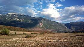
Gjallica or Gjallica e Lumës is a limestone mountain at 2,487 m (8,159 ft) above sea level and the highest summit in the region of Kukës County, Albania.[3] It lies 8 km (5 mi) southeast of the city of Kukës, having a cap covered by snow up to June when the winters are cold and snowy.
The mountain falls within the Balkan mixed forests and Dinaric Mountains mixed forests terrestrial ecoregions of the Palearctic Temperate broadleaf and mixed forest. The slopes of the mountain is entirely covered with coniferous forests. It has thick vegetation of pines and beeches on high altitude, but sparse vegetation on the foot of the mountain due to the now closed plant that emitted harmful gases for the vegetation close to it. Gjallica appears to be very tall because the Black Drin valley to its west is only 250 m (820 ft) above sea level.[4]
 Gjallica peak |
 View from the mountain and Kukës |
 Snowy Gjallica |
See also
| Wikimedia Commons has media related to Gjallica. |
References
- ↑ "TREGUES SIPAS QARQEVE INDICATORS BY PREFECTURES" (PDF). Archived from the original (PDF) on 2011-07-24. Retrieved 2011-07-24.
- ↑ "STRATEGJIA TERRITORIALE E NJËSISË VENDORE KUKËS" (PDF). kukesi.gov.al. p. 14.
- ↑ Peter Dawson; Linda White; Andrea Dawson (March 1995). Albania: a guide and illustrated journal. Bradt Publications. p. 97. ISBN 978-1-898323-10-5.
- ↑ "Albanian or South Dinaric Alps". Summitpost. Retrieved 2008-12-31.