Merxheim, Haut-Rhin
| Merxheim | ||
|---|---|---|
| Commune | ||
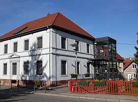 The town hall of Merxheim | ||
| ||
 Merxheim Location within Grand Est region  Merxheim | ||
| Coordinates: 47°54′41″N 7°17′36″E / 47.9114°N 7.2933°ECoordinates: 47°54′41″N 7°17′36″E / 47.9114°N 7.2933°E | ||
| Country | France | |
| Region | Grand Est | |
| Department | Haut-Rhin | |
| Arrondissement | Thann-Guebwiller | |
| Canton | Guebwiller | |
| Government | ||
| • Mayor (2001–2008) | Patrice Fluck | |
| Area1 | 9.1 km2 (3.5 sq mi) | |
| Population (2006)2 | 1,280 | |
| • Density | 140/km2 (360/sq mi) | |
| Time zone | UTC+1 (CET) | |
| • Summer (DST) | UTC+2 (CEST) | |
| INSEE/Postal code | 68203 /68500 | |
| Elevation |
208–229 m (682–751 ft) (avg. 220 m or 720 ft) | |
|
1 French Land Register data, which excludes lakes, ponds, glaciers > 1 km2 (0.386 sq mi or 247 acres) and river estuaries. 2 Population without double counting: residents of multiple communes (e.g., students and military personnel) only counted once. | ||
.svg.png)
Merxheim is a commune in the Haut-Rhin department in Grand Est in north-eastern France.
See also
References
| Wikimedia Commons has media related to Merxheim (Haut-Rhin). |
This article is issued from
Wikipedia.
The text is licensed under Creative Commons - Attribution - Sharealike.
Additional terms may apply for the media files.