Willer-sur-Thur
| Willer-sur-Thur | ||
|---|---|---|
| Commune | ||
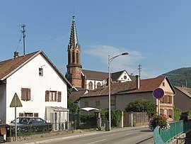 The church and surroundings in Willer-sur-Thur | ||
| ||
 Willer-sur-Thur Location within Grand Est region  Willer-sur-Thur | ||
| Coordinates: 47°50′40″N 7°04′25″E / 47.8444°N 7.0736°ECoordinates: 47°50′40″N 7°04′25″E / 47.8444°N 7.0736°E | ||
| Country | France | |
| Region | Grand Est | |
| Department | Haut-Rhin | |
| Arrondissement | Thann-Guebwiller | |
| Canton | Cernay | |
| Intercommunality | Thann-Cernay | |
| Government | ||
| • Mayor (2014-2020) | Jean-Luc Martini | |
| Area1 | 18.0 km2 (6.9 sq mi) | |
| Population (2014)2 | 1,855 | |
| • Density | 100/km2 (270/sq mi) | |
| Time zone | UTC+1 (CET) | |
| • Summer (DST) | UTC+2 (CEST) | |
| INSEE/Postal code | 68372 /68760 | |
| Elevation |
356–1,183 m (1,168–3,881 ft) (avg. 370 m or 1,210 ft) | |
|
1 French Land Register data, which excludes lakes, ponds, glaciers > 1 km2 (0.386 sq mi or 247 acres) and river estuaries. 2 Population without double counting: residents of multiple communes (e.g., students and military personnel) only counted once. | ||
.svg.png)
Willer-sur-Thur (German: Weiler an der Thur) is a commune in the Haut-Rhin department in Grand Est in north-eastern France.
See also
References
| Wikimedia Commons has media related to Willer-sur-Thur. |
| Authority control |
|---|
This article is issued from
Wikipedia.
The text is licensed under Creative Commons - Attribution - Sharealike.
Additional terms may apply for the media files.