Michelbach-le-Haut
| Michelbach-le-Haut | ||
|---|---|---|
| Commune | ||
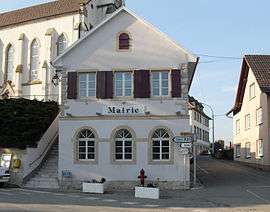 The town hall in Michelbach-le-Haut | ||
| ||
 Michelbach-le-Haut Location within Grand Est region  Michelbach-le-Haut | ||
| Coordinates: 47°34′02″N 7°26′41″E / 47.5672°N 7.4447°ECoordinates: 47°34′02″N 7°26′41″E / 47.5672°N 7.4447°E | ||
| Country | France | |
| Region | Grand Est | |
| Department | Haut-Rhin | |
| Arrondissement | Mulhouse | |
| Canton | Saint-Louis | |
| Intercommunality | Porte du Sundgau | |
| Government | ||
| • Mayor (2001–2008) | André Wolgensinger | |
| Area1 | 7.38 km2 (2.85 sq mi) | |
| Population (2006)2 | 485 | |
| • Density | 66/km2 (170/sq mi) | |
| Time zone | UTC+1 (CET) | |
| • Summer (DST) | UTC+2 (CEST) | |
| INSEE/Postal code | 68208 /68220 | |
| Elevation |
324–468 m (1,063–1,535 ft) (avg. 350 m or 1,150 ft) | |
|
1 French Land Register data, which excludes lakes, ponds, glaciers > 1 km2 (0.386 sq mi or 247 acres) and river estuaries. 2 Population without double counting: residents of multiple communes (e.g., students and military personnel) only counted once. | ||
.svg.png)
Michelbach-le-Haut (German: Obermichelbach) is a commune in the Haut-Rhin department in Alsace in north-eastern France.
See also
References
| Wikimedia Commons has media related to Michelbach-le-Haut. |
This article is issued from
Wikipedia.
The text is licensed under Creative Commons - Attribution - Sharealike.
Additional terms may apply for the media files.