Westhalten
| Westhalten | ||
|---|---|---|
| Commune | ||
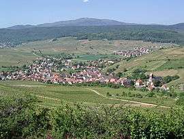 A general view of Westhalten | ||
| ||
 Westhalten Location within Grand Est region  Westhalten | ||
| Coordinates: 47°57′28″N 7°15′34″E / 47.9578°N 7.2594°ECoordinates: 47°57′28″N 7°15′34″E / 47.9578°N 7.2594°E | ||
| Country | France | |
| Region | Grand Est | |
| Department | Haut-Rhin | |
| Arrondissement | Thann-Guebwiller | |
| Canton | Wintzenheim | |
| Intercommunality | Pays Rouffach Vignobles Châteaux | |
| Government | ||
| • Mayor (2014-2020) | Gérard Schatz | |
| Area1 | 10.98 km2 (4.24 sq mi) | |
| Population (2014)2 | 979 | |
| • Density | 89/km2 (230/sq mi) | |
| Time zone | UTC+1 (CET) | |
| • Summer (DST) | UTC+2 (CEST) | |
| INSEE/Postal code | 68364 /68250 | |
| Elevation |
217–576 m (712–1,890 ft) (avg. 240 m or 790 ft) | |
|
1 French Land Register data, which excludes lakes, ponds, glaciers > 1 km2 (0.386 sq mi or 247 acres) and river estuaries. 2 Population without double counting: residents of multiple communes (e.g., students and military personnel) only counted once. | ||
.svg.png)
Westhalten is a commune in the Haut-Rhin department in Grand Est in north-eastern France.
Its vineyards produce three of the finest Alsacian wines: the Grands Crus Steinert, Vorbourg and Zinnkoepflé.
See also
References
| Wikimedia Commons has media related to Westhalten. |
This article is issued from
Wikipedia.
The text is licensed under Creative Commons - Attribution - Sharealike.
Additional terms may apply for the media files.