Soppe-le-Bas
| Soppe-le-Bas | ||
|---|---|---|
| Commune | ||
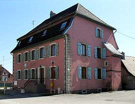 The town hall in Soppe-le-Bas | ||
| ||
 Soppe-le-Bas Location within Grand Est region  Soppe-le-Bas | ||
| Coordinates: 47°43′05″N 7°05′25″E / 47.7181°N 7.0903°ECoordinates: 47°43′05″N 7°05′25″E / 47.7181°N 7.0903°E | ||
| Country | France | |
| Region | Grand Est | |
| Department | Haut-Rhin | |
| Arrondissement | Thann-Guebwiller | |
| Canton | Masevaux | |
| Intercommunality | Vallée de la Doller et du Soultzbach | |
| Government | ||
| • Mayor (2001–2008) | Francis Guttig | |
| Area1 | 5.68 km2 (2.19 sq mi) | |
| Population (2006)2 | 746 | |
| • Density | 130/km2 (340/sq mi) | |
| Time zone | UTC+1 (CET) | |
| • Summer (DST) | UTC+2 (CEST) | |
| INSEE/Postal code | 68313 /68780 | |
| Elevation |
297–380 m (974–1,247 ft) (avg. 320 m or 1,050 ft) | |
|
1 French Land Register data, which excludes lakes, ponds, glaciers > 1 km2 (0.386 sq mi or 247 acres) and river estuaries. 2 Population without double counting: residents of multiple communes (e.g., students and military personnel) only counted once. | ||
.svg.png)
Soppe-le-Bas (German: Niedersulzbach) is a commune in the Haut-Rhin department in Grand Est in north-eastern France.
See also
References
| Wikimedia Commons has media related to Soppe-le-Bas. |
This article is issued from
Wikipedia.
The text is licensed under Creative Commons - Attribution - Sharealike.
Additional terms may apply for the media files.