Oberhergheim
| Oberhergheim | ||
|---|---|---|
| Commune | ||
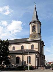 The church in Oberhergheim | ||
| ||
 Oberhergheim Location within Grand Est region  Oberhergheim | ||
| Coordinates: 47°58′02″N 7°23′46″E / 47.9672°N 7.3961°ECoordinates: 47°58′02″N 7°23′46″E / 47.9672°N 7.3961°E | ||
| Country | France | |
| Region | Grand Est | |
| Department | Haut-Rhin | |
| Arrondissement | Thann-Guebwiller | |
| Canton | Ensisheim | |
| Intercommunality | Centre Haut-Rhin | |
| Government | ||
| • Mayor (2001–2008) | Paul Hegy | |
| Area1 | 19.86 km2 (7.67 sq mi) | |
| Population (2006)2 | 1,188 | |
| • Density | 60/km2 (150/sq mi) | |
| Time zone | UTC+1 (CET) | |
| • Summer (DST) | UTC+2 (CEST) | |
| INSEE/Postal code | 68242 /68127 | |
| Elevation |
197–207 m (646–679 ft) (avg. 202 m or 663 ft) | |
|
1 French Land Register data, which excludes lakes, ponds, glaciers > 1 km2 (0.386 sq mi or 247 acres) and river estuaries. 2 Population without double counting: residents of multiple communes (e.g., students and military personnel) only counted once. | ||
.svg.png)
Oberhergheim is a commune in the Haut-Rhin department in Grand Est in north-eastern France.
See also
References
| Wikimedia Commons has media related to Oberhergheim. |
This article is issued from
Wikipedia.
The text is licensed under Creative Commons - Attribution - Sharealike.
Additional terms may apply for the media files.