Katzenthal
| Katzenthal | ||
|---|---|---|
| Commune | ||
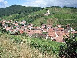 A general view of Katzenthal | ||
| ||
 Katzenthal Location within Grand Est region  Katzenthal | ||
| Coordinates: 48°06′30″N 7°16′58″E / 48.1083°N 7.2828°ECoordinates: 48°06′30″N 7°16′58″E / 48.1083°N 7.2828°E | ||
| Country | France | |
| Region | Grand Est | |
| Department | Haut-Rhin | |
| Arrondissement | Colmar-Ribeauvillé | |
| Canton | Sainte-Marie-aux-Mines | |
| Intercommunality | Vallée de Kaysersberg | |
| Government | ||
| • Mayor (2008–2014) | Nicole Tisserand | |
| Area1 | 3.5 km2 (1.4 sq mi) | |
| Population (2006)2 | 549 | |
| • Density | 160/km2 (410/sq mi) | |
| Time zone | UTC+1 (CET) | |
| • Summer (DST) | UTC+2 (CEST) | |
| INSEE/Postal code | 68161 /68230 | |
| Elevation |
210–660 m (690–2,170 ft) (avg. 280 m or 920 ft) | |
|
1 French Land Register data, which excludes lakes, ponds, glaciers > 1 km2 (0.386 sq mi or 247 acres) and river estuaries. 2 Population without double counting: residents of multiple communes (e.g., students and military personnel) only counted once. | ||
.svg.png)
Katzenthal is a commune in the Haut-Rhin department in Grand Est in north-eastern France.
See also
References
| Wikimedia Commons has media related to Katzenthal. |
This article is issued from
Wikipedia.
The text is licensed under Creative Commons - Attribution - Sharealike.
Additional terms may apply for the media files.