Biederthal
| Biederthal Bierthel | ||
|---|---|---|
| Commune | ||
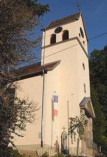 Saint Michael Church in Biederthal | ||
| ||
 Biederthal Location within Grand Est region  Biederthal | ||
| Coordinates: 47°28′14″N 7°26′57″E / 47.4706°N 7.4492°ECoordinates: 47°28′14″N 7°26′57″E / 47.4706°N 7.4492°E | ||
| Country | France | |
| Region | Grand Est | |
| Department | Haut-Rhin | |
| Arrondissement | Altkirch | |
| Canton | Altkirch | |
| Intercommunality | Jura alsacien | |
| Government | ||
| • Mayor (2008–2014) | Dominique Geyer | |
| Area1 | 4.16 km2 (1.61 sq mi) | |
| Population (2006)2 | 350 | |
| • Density | 84/km2 (220/sq mi) | |
| Time zone | UTC+1 (CET) | |
| • Summer (DST) | UTC+2 (CEST) | |
| INSEE/Postal code | 68035 /68480 | |
| Elevation |
375–530 m (1,230–1,739 ft) (avg. 420 m or 1,380 ft) | |
|
1 French Land Register data, which excludes lakes, ponds, glaciers > 1 km2 (0.386 sq mi or 247 acres) and river estuaries. 2 Population without double counting: residents of multiple communes (e.g., students and military personnel) only counted once. | ||
.svg.png)
Biederthal (Alemannic German: Bierthel) is a commune in the Haut-Rhin department in Alsace in north-eastern France. It is located on the border with Switzerland, next to the Swiss villages of Rodersdorf and Metzerlen-Mariastein.
See also
References
| Wikimedia Commons has media related to Biederthal. |
This article is issued from
Wikipedia.
The text is licensed under Creative Commons - Attribution - Sharealike.
Additional terms may apply for the media files.