Meru County
| Meru County | |||
|---|---|---|---|
| County | |||
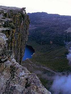 Lake Michaelson is in the background | |||
| |||
 Location of Meru County in Kenya | |||
| Coordinates: 0°3′N 37°38′E / 0.050°N 37.633°ECoordinates: 0°3′N 37°38′E / 0.050°N 37.633°E | |||
| Country |
| ||
| Formed | March 4, 2013 | ||
| Capital and largest town | Meru | ||
| Government | |||
| • Governor | Kiraitu Murungi | ||
| Area | |||
| • Total | 6,936 km2 (2,678 sq mi) | ||
| Population (2009)[1] | |||
| • Total | 1,356,301 | ||
| • Density | 200/km2 (510/sq mi) | ||
| Time zone | UTC+3 (EAT) | ||
| Website |
meru | ||


Meru County is one of the 47 counties of Kenya, located in the former Eastern Province. It has a population of 1.4 million people.
Meru County is the home of the Ngaa People (Meru), who are related to other ethnicities living around the Mount Kenya region: the Kikuyu, Embu people and to some extent the Kamba people Also, peoples from the east coast of Kenya, along the Indian Ocean, like the Bajuni, Swahili, Mijikenda, and further inland, the Taita, Taveta and westwards to the Lake Victoria coast, the Kisii and Maragoli as well as other Luhya people, are all related to the Meru.
The county headquarters is in the town of Meru. The current governor of Meru County is Hon. Kiraitu Murungi of Jubilee Party.
History
In 1992, the former Meru District was split into Meru Central District, Meru North District, Meru South District, and Tharaka District. In 1998, Tharaka District was again split into Nithi District and Tharaka District. A Supreme Court decision in September 2009 ruled that the split had been unconstitutional, and the first two of these were re-amalgamated into Meru District, which became Meru County in 2010. The same ruling amalgamated Meru South, Tharaka and Nithi districts into Tharaka-Nithi District, which became Tharaka-Nithi County in 2010.