Spartansburg, Pennsylvania
| Spartansburg, Pennsylvania | |
|---|---|
| Borough | |
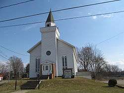 Methodist church on Main Street | |
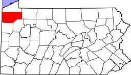
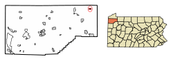 Location of Spartansburg in Crawford County, Pennsylvania. | |
 Spartansburg Location of Spartansburg in Pennsylvania | |
| Coordinates: 41°49′26″N 79°41′1″W / 41.82389°N 79.68361°WCoordinates: 41°49′26″N 79°41′1″W / 41.82389°N 79.68361°W | |
| Country | United States |
| State | Pennsylvania |
| County | Crawford County |
| Founded | 1830 |
| Government | |
| • Mayor | Ann Louise Wagner |
| Area[1] | |
| • Total | 0.71 sq mi (1.83 km2) |
| • Land | 0.68 sq mi (1.76 km2) |
| • Water | 0.03 sq mi (0.08 km2) |
| Elevation | 1,450 ft (440 m) |
| Population (2010) | |
| • Total | 305 |
| • Estimate (2016)[2] | 299 |
| • Density | 440.35/sq mi (170.14/km2) |
| Time zone | UTC-4 (EST) |
| • Summer (DST) | UTC-5 (EDT) |
| Area code(s) | 814 |
Spartansburg is a borough in Crawford County, in northwest Pennsylvania, United States. The population was 305 at the 2010 census.[3]
Geography
Spartansburg is located near the northeast corner of Crawford County at 41°49′19″N 79°41′9″W / 41.82194°N 79.68583°W (41.821980, -79.685957).[4] It is surrounded by Sparta Township, a separate municipality.
Pennsylvania Route 77 passes through the center of the borough, leading northeast 8 miles (13 km) to Corry and southwest 28 miles (45 km) to Meadville, the Crawford County seat.
According to the United States Census Bureau, the borough has a total area of 0.71 square miles (1.83 km2), of which 0.68 square miles (1.76 km2) is land and 0.03 square miles (0.08 km2), or 4.23%, is water.[3] The town is situated on either side of the East Branch of Oil Creek, where it begins at the outlet of Clear Lake.
Demographics
| Historical population | |||
|---|---|---|---|
| Census | Pop. | %± | |
| 1860 | 235 | — | |
| 1870 | 457 | 94.5% | |
| 1880 | 486 | 6.3% | |
| 1890 | 516 | 6.2% | |
| 1900 | 488 | −5.4% | |
| 1910 | 460 | −5.7% | |
| 1920 | 450 | −2.2% | |
| 1930 | 374 | −16.9% | |
| 1940 | 423 | 13.1% | |
| 1950 | 482 | 13.9% | |
| 1960 | 500 | 3.7% | |
| 1970 | 464 | −7.2% | |
| 1980 | 403 | −13.1% | |
| 1990 | 403 | 0.0% | |
| 2000 | 333 | −17.4% | |
| 2010 | 305 | −8.4% | |
| Est. 2016 | 299 | [2] | −2.0% |
| Sources:[5][6][7] | |||

As of the census[6] of 2000, there were 333 people, 130 households, and 93 families residing in the borough. The population density was 499.1 people per square mile (191.9/km²). There were 140 housing units at an average density of 209.8 per square mile (80.7/km²). The racial makeup of the borough was 100.00% White.
There were 130 households, out of which 34.6% had children under the age of 18 living with them, 59.2% were married couples living together, 7.7% had a female householder with no husband present, and 27.7% were non-families. 26.9% of all households were made up of individuals, and 14.6% had someone living alone who was 65 years of age or older. The average household size was 2.56 and the average family size was 3.06.
In the borough the population was spread out, with 26.4% under the age of 18, 6.9% from 18 to 24, 26.1% from 25 to 44, 24.6% from 45 to 64, and 15.9% who were 65 years of age or older. The median age was 39 years. For every 100 females there were 89.2 males. For every 100 females age 18 and over, there were 88.5 males.
The median income for a household in the borough was $26,731, and the median income for a family was $34,063. Males had a median income of $33,750 versus $27,656 for females. The per capita income for the borough was $16,035. About 14.7% of families and 13.7% of the population were below the poverty line, including 18.2% of those under age 18 and 26.0% of those age 65 or over.
Education
Spartansburg is served by the Corry Area School District. Schools include Corry Area Middle & High School.
Notable people
- Ray Harroun, winner of the inaugural Indianapolis 500 in 1911.
In popular culture
- Spartansburg appeared in the Discovery Channel show Dirty Jobs.[8]
References
- ↑ "2016 U.S. Gazetteer Files". United States Census Bureau. Retrieved Aug 13, 2017.
- 1 2 "Population and Housing Unit Estimates". Retrieved June 9, 2017.
- 1 2 "Geographic Identifiers: 2010 Census Summary File 1 (G001): Spartansburg borough, Pennsylvania". U.S. Census Bureau, American Factfinder. Retrieved June 4, 2015.
- ↑ "US Gazetteer files: 2010, 2000, and 1990". United States Census Bureau. 2011-02-12. Retrieved 2011-04-23.
- ↑ "Census of Population and Housing". U.S. Census Bureau. Retrieved 11 December 2013.
- 1 2 "American FactFinder". United States Census Bureau. Retrieved 2008-01-31.
- ↑ "Incorporated Places and Minor Civil Divisions Datasets: Subcounty Resident Population Estimates: April 1, 2010 to July 1, 2012". Population Estimates. U.S. Census Bureau. Archived from the original on 17 June 2013. Retrieved 11 December 2013.
- ↑ "Dirty Jobs - Season 2, Episode 16: Viewer's Choice". Retrieved 31 July 2012.