Maricá, Rio de Janeiro
Coordinates: 22°55′08″S 42°49′08″W / 22.91889°S 42.81889°W
| Maricá | |||
|---|---|---|---|
| Municipality | |||
| Município de Maricá | |||
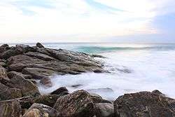 Ponta Negra Beach | |||
| |||
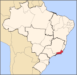
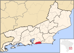 Location in the Rio de Janeiro state. | |||
| Government | |||
| • Mayor | Fabiano Horta (2017-2020) (PT) | ||
| Area | |||
| • Municipality | 362 km2 (140 sq mi) | ||
| Elevation | 6 m (20 ft) | ||
| Population (est. IBGE/2017 [1]) | |||
| • Municipality | 153.008 pessoas | ||
| • Density | 661.3/km2 (1,713/sq mi) | ||
| • Metro | 1,795,015 | ||
| Time zone | UTC-3 (Brasília Time Zone) | ||


Maricá (Portuguese pronunciation: [maɾiˈka]) is a municipality located in the Brazilian state of Rio de Janeiro.
Geography
Maricá is a city of the Rio de Janeiro Metropolitan Area, located on the coast of the Atlantic Ocean and 25 miles away from the city of Rio de Janeiro.
The municipality contains part of the 2,400 hectares (5,900 acres) Serra da Tiririca State Park, created in 1991.[2]
Population
Its population was 146.549 (2015). [3]
Area
Its area is 362,571 km².[4]
Transportation
Maricá has an airport, the Maricá Airport. Maricá is served by the roads BR-116 and RJ-104.
Economy
Maricá has received many royalties from the Brazilian energy company Petrobras, because of the Campos Basin and Santos Basin oil field.
References
- ↑ "Estimativas da população para 1º de julho de 2017". Instituto Brasileiro de Geografia e Estatística (IBGE). 1 July 2017. Retrieved 7 May 2018.
- ↑ Parque Estadual da Serra da Tiririca (in Portuguese), UERJ: Universidade do Estado do Rio de Janeiro, retrieved 2017-02-07
- ↑ "Estimativas da população para 1º de julho de 2015" (PDF). Instituto Brasileiro de Geografia e Estatística (IBGE). 1 July 2015. Retrieved 13 February 2016.
- ↑ IBGE - "Archived copy". Archived from the original on 2007-01-09. Retrieved 2007-01-09.
Capital: Rio de Janeiro | |||||||||||
| Mesoregion Baixadas |
|  | |||||||||
| Mesoregion Centro Fluminense |
| ||||||||||
| Mesoregion Metropolitana do Rio de Janeiro |
| ||||||||||
| Mesoregion Noroeste Fluminense |
| ||||||||||
| Mesoregion Norte Fluminense |
| ||||||||||
| Mesoregion Sul Fluminense |
| ||||||||||
This article is issued from
Wikipedia.
The text is licensed under Creative Commons - Attribution - Sharealike.
Additional terms may apply for the media files.