Campos Basin
| Campos Basin | |
|---|---|
| Bacia do Campos | |
 | |
| Coordinates | 22°28′52″S 34°50′00″W / 22.48111°S 34.83333°WCoordinates: 22°28′52″S 34°50′00″W / 22.48111°S 34.83333°W |
| Etymology | Campos |
| Region | Southeast |
| Country |
|
| State(s) | Rio de Janeiro, Espírito Santo |
| Cities | Campos dos Goytacazes |
| Characteristics | |
| On/Offshore | Both, mostly offshore |
| Boundaries | Vitória, Cabo Frio Highs, Serra do Mar |
| Part of | Brazilian Atlantic margin |
| Area | ~115,000 km2 (44,000 sq mi) |
| Hydrology | |
| Sea(s) | South Atlantic |
| Geology | |
| Basin type | Passive margin on rift basin |
| Plate | South American |
| Orogeny | Break-up of Gondwana |
| Age | Neocomian-recent |
| Stratigraphy | Stratigraphy |
| Field(s) | Marlim, Albacora-Leste, Barracuda, Roncador, Cachalote, Badejo |
The Campos Basin is one of 12 coastal sedimentary basins of Brazil. It spans both onshore and offshore parts of the South Atlantic with the onshore part located near Rio de Janeiro. The basin originated in Neocomian stage of the Cretaceous period 145–130 million years ago during the breakup of Gondwana. It has a total area of about 115,000 square kilometres (44,000 sq mi), with the onshore portion small at only 500 square kilometres (190 sq mi).[1]
Etymology
The Campos Basin is named after the city of Campos dos Goytacazes in the state of Rio de Janeiro.
Description
The Campos Basin is bound on the south by the Cabo Frio High, separating the basin from the Santos Basin and on the north by the Vitória High, forming the boundary with the Espírito Santo Basin. Campos Basin contains the Paraiba do Sul River delta.[2]
Tectonic history

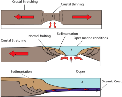
The South Atlantic margin developed on Archean stable cratons consisting of hard and resistant rocks and partly on the Neoproterozoic mobile belts composed of less resistant metamorphic rocks.[4] The Precambrian basement of the Santos Basin is exposed as the Araçuaí Belt along the Brazilian coast, most notably in the inselbergs of Rio de Janeiro, of which Sugarloaf Mountain is the most iconic. The ancient rocks consist of a Neoproterozoic to Cambrian high-grade metamorphic core of granites and gneisses, formed during the collision of Gondwana in the Pan-African-Brasiliano orogeny.[5] Basalts similar to the Paraná and Etendeka traps, exposed to the west in the Paraná Basin, have been found underlying the Santos Basin.[6] The Tristan da Cunha hotspot, known as the Tristan hotspot, is considered the driver behind the formation of these flood basalts.[7]
During the Early Cretaceous, the former continent Gondwana, as southern part of Pangea, starting to break-up, resulting in a sequence of rift basins bordering the present-day South Atlantic. The Pelotas-Namibia spreading commenced in the Hauterivian, around 133 million years ago and reached the Santos Basin to the north in the Barremian. Seafloor spreading continued northwards to the Campos Basin in the Early Albian, at approximately 112 Ma.
Five tectonic stages have been identified in the Brazilian basins:[8]
- Pre-rift stage - Jurassic to Valanginian
- Syn-rift stage - Hauterivian to Late Barremian
- Sag stage - Late Barremian to Late Aptian
- Post-rift stage - Early to Middle Albian
- Drift stage - Late Albian to Holocene
Stratigraphy
Oil reservoirs include formations deposited during the Aptian and pre-Aptian continental rift phase, of post-salt Albian-Cenomanian shallow-water marine carbonates and deepwater sandstones, and in turbidites of the open marine drift phase of Late Cretaceous and early Tertiary ages.[2]
The Namorado Field "location was selected based on seismic interpretation of a structural high at the top of the Macaé Formation (Albian limestones)" at a depth of about 3 kilometres (9,800 ft),[2] and the reservoirs are marine turbidite deposits transgressing over the Albian limestone shelf.[2]
The stratigraphy starts with basalt flows dated at 120 Ma, overlain by the Lagoa Feia Group, consisting of the organic-rich lacustrine "green shales" followed by lacustrine limestones and continental sandstones and conglomerates, transitioning into marine sediments with evaporites, limestones, and limestone altered dolomites.[2] The shallow marine limestones of the Macaé Formation follow, then the Namorado turbidite sandstones, and finally the Campos Formation, consisting of the turbidite sandstone Carapebus Member and the prograding slope and shelf Ubatuba Formation.[2]
Exploration
The off-shore oil exploration in the Campos Basin began in 1968.[9] The first exploratory well was drilled in 1971. The first field to be discovered was Garoupa in 1974, at a shallow water depth of 120 metres (390 ft), followed by Namorado in 1975 in 166 metres (545 ft) of water.[2] The first oil production started in 1977 from Enchova Field, at a water depth of 124 metres (407 ft).[1] The largest fields, listed by their year of discovery year, include Linguado (1978), Carapeba (1982), Vermelho (1982), Marimba (1984),[10]:137–152 Albacora (1984), Marlim (1985), Albacora-Leste (1986), Marlim Sul (1987), Marlim Leste (1987), Barracuda (1989), Caratinga (1989), Espadarte (1994), Roncador (1996), Jubarte (2002), Cachalote (2002), and Badejo (2008). The largest Marlim field is located in the northeast of the basin, 110 kilometres (68 mi) offshore in water depths ranging from 650 to 1,050 metres (2,130 to 3,440 ft).[9]
By 2003, 41 oil and gas fields were discovered, which ranging at distances from 50 to 140 kilometres (31 to 87 mi) from the coast and at water depths varying from 80 to 2,400 metres (260 to 7,870 ft). Of these fields, 37 are being developed by Petrobras. By 2003, the oil production from the basin had reached 1.21 million barrels per day. The production comes from a variety of reservoirs including siliciclastic turbidites, fractured basalts, coquinas, calcarenites (limestones). The total cumulative production from the Campos Basin by 2003 was 3.9 billion barrels of oil with remaining reserves of 8.5 billion barrels.[1]
In February 2010, a new 65 million barrel discovery was made by Petrobras near the Barracuda oil field.[11]
See also
References
- 1 2 3 Bruhn et al., 2003
- 1 2 3 4 5 6 7 Bacoccoli et al., 1980
- ↑ Love, 2015, 16:16
- ↑ Clemente, 2013, p.3
- ↑ Owen, 2014, p.36
- ↑ Peate, 1997, p.220
- ↑ Beasley et al., 2010, p.31
- ↑ Contreras, 2011, p.7
- 1 2 Fraga et al., 2003
- ↑ Horschutz et al., 1992
- ↑ Flower, Merlin (3 March 2010). "Petrobras discovers oil again". OIL-PRICE.NET. Retrieved 25 July 2012.
Bibliography and further reading
Brazil general
- ANP, .. 2015. Summary of the sedimentary basins, 1–15. ANP. Accessed 2017-09-04.
- Beasley, Craig J.; Joseph Carl Fiduk; Emmanuel Bize; Austin Boyd; Marcelo Frydman; Andrea Zerilli; John R. Dribus; Jobel L.P. Moreira, and Antonio C. Capeleiro Pinto. 2010. Brazil's Pre-Salt Play. Oilfield Review 22. 28–37. Accessed 2017-09-04.
- Bryant, Ian; Nora Herbst; Paul Dailly; John R. Dribus; Roberto Fainstein; Nick Harvey; Angus McCoss; Bernard Montaron, and David Quirk, Paul Tapponnier. 2012. Basin to Basin: Plate Tectonics in Exploration. Oilfield Review 24. 38–57. Accessed 2017-09-04.
- Love, Frank. 2013. South Atlantic Pre-Salt Play Elements, Play Potential and Continental Margin Types, 1:06:49. Houston Geological Society. Accessed 2017-09-04.
- Oddone, Décio. 2017. The Petroleum Potential of the Brazilian Sedimentary Basins, 1–44. Brazilian Geophysical Society & EXPOGEf. Accessed 2017-09-04.
- Peate, David W. 1997. The Paraná-Etendeka Province. Geophysical Monograph 100. 217–245. Accessed 2017-09-04.
Campos Basin geology
- Albertão, Gilberto Athayde; Pedro Paes de Carvalho; Marcelo Blauth; Alexandre Dutra Sayd, and K.T. Ratcliffe. 2013. Application of chemostratigraphy in the study of carbonate reservoirs of the Campos Basin, 1–4. Chemostrat Inc.. Accessed 2017-09-04.
- Beglinger, Suzanne E.; Jan-Diederik Van Wees; Sierd Cloetingh, and Harry Doust. 2012. Tectonic subsidence history and source-rock maturation in the Campos Basin, Brazil. Petroleum Geoscience 18. 153–172. Accessed 2017-09-04.
- Calazans Muniz, Moises. 20. Tectono-Stratigraphic evolution of the Barremian-Aptian Continental Rift Carbonates in Southern Campos Basin, Brazil (PhD thesis), 1–343. Royal Holloway University of London. Accessed 2017-09-04.
- Contreras, Jorham. 2011. Seismo-stratigraphy and numerical basin modeling of the southern Brazilian continental margin (Campos, Santos, and Pelotas basins) (PhD thesis), 1–171. Ruprecht-Karls-Universität Heidelberg. Accessed 2017-09-04.
- Kattah, Senira. 2017. Exploration Opportunities in the Pre-Salt Play, Deepwater Campos Basin, Brazil. The Sedimentary Record 15. 4–8. Accessed 2017-09-04.
- Okubo, Juliana; Ricardo Lykawka; Lucas Veríssimo Warren; Julia Favoreto, and Dimas Dias Brito. 2015. Depositional, diagenetic and stratigraphic aspects of Macaé Group carbonates (Albian): example from an oilfield from Campos Basin. Brazilian Journal of Geology 45. 243–258. Accessed 2017-09-04.
Campos Basin exploration
- Bacoccoli, G.; R.G. Morales, and O.A.J. Campos. 1980. The Namorado Oil Field: A Major Oil Discovery in the Campos Basin, Brazil. AAPG Memoir, Giant Oil and Gas Fields of the Decade: 1968-1978 ISBN 0891813063 30. 329–338.
- Bruhn, Carlos H.L.; José Adilson T. Gomes, and Cesar Del Lucchese Jr.. 2003. Campos Basin: Reservoir Characterization and Management — Historical Overview and Future Challenges. Offshore Technology Conference OTC 15220. . Accessed 2017-09-04.
- Clemente, Pilar. 2013. Petroleum geology of the Campos and Santos basins, Lower Cretaceous Brazilian sector of the South Atlantic margin, 1–33. Danmarks Tekniske Universitet. Accessed 2017-09-04.
- Fraga, C.T. da Costa; F.A. Borges, and R. Beltrão. 2003. Campos Basin – 25 Years of Production and its Contribution to the Oil Industry. Offshore Technology Conference OTC 15219. . Accessed 2017-09-04.
- Horschutz, P.M.C.; L.C.S. De Freitas; C.V. Stank; A. da S. Barroso, and W.M. Cruz. 1992. The Linguado, Carapeba, Vermelho, and Marimba Giant Oil Fields, Campos Basin, Offshore Brazil. AAPG Memoir, Giant Oil and Gas Fields of the Decade, 1978-1988 ISBN 0891813330 54. 137–152.
- Juarez Feijó, Fávio. 2013. Santos Basin: 40 Years from Shallow to Deep to Ultra-Deep Water. Search and Discovery 10553. 1–49. Accessed 2017-09-04.
External links
Sedimentary basins of Brazil | ||||||||||
|---|---|---|---|---|---|---|---|---|---|---|
| Onshore |
| | ||||||||
| Offshore |
| |||||||||
| Source |
| |||||||||