Engenheiro Paulo de Frontin, Rio de Janeiro
| Engenheiro Paulo de Frontin | |||
|---|---|---|---|
| Municipality | |||
| Município de Engenheiro Paulo de Frontin | |||
 Sacra Família Church | |||
| |||
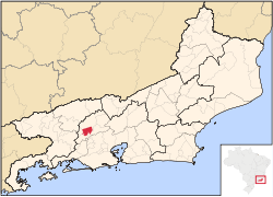 Location of Engenheiro Paulo de Frontin in the state of Rio de Janeiro | |||
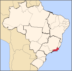
 Engenheiro Paulo de Frontin Location of Engenheiro Paulo de Frontin in Brazil | |||
| Coordinates: 22°33′00″S 43°40′40″W / 22.55000°S 43.67778°WCoordinates: 22°33′00″S 43°40′40″W / 22.55000°S 43.67778°W | |||
| Country |
| ||
| Region | Southeast | ||
| State |
| ||
| Government | |||
| • Prefeito | Jauldo de Souza Balthazar Ferreira (PHS) | ||
| Area | |||
| • Total | 139.008 km2 (53.671 sq mi) | ||
| Elevation | 395 m (1,296 ft) | ||
| Population (2010) | |||
| • Total | 13,521 | ||
| Time zone | UTC-3 (UTC-3) | ||
| Website | |||


Engenheiro Paulo de Frontin (Portuguese pronunciation: [ẽʒẽˈɲe(j)ɾu ˈpawlu dʒi fɾõˈtẽj]) is a municipality located in the Brazilian state of Rio de Janeiro. Its population was 13,525 (2010) and its area is 139 km².[1]
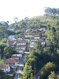
Street in the city
References
- ↑ IBGE - "Archived copy". Archived from the original on 2007-01-09. Retrieved 2014-08-03.
Capital: Rio de Janeiro | |||||||||||
| Mesoregion Baixadas |
|  | |||||||||
| Mesoregion Centro Fluminense |
| ||||||||||
| Mesoregion Metropolitana do Rio de Janeiro |
| ||||||||||
| Mesoregion Noroeste Fluminense |
| ||||||||||
| Mesoregion Norte Fluminense |
| ||||||||||
| Mesoregion Sul Fluminense |
| ||||||||||
This article is issued from
Wikipedia.
The text is licensed under Creative Commons - Attribution - Sharealike.
Additional terms may apply for the media files.