Seropédica
| Seropédica | |||
|---|---|---|---|
| Municipality | |||
| Município de Seropédica | |||
 | |||
| |||
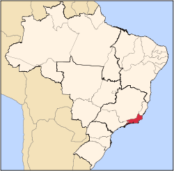
 Location of Seropédica in the state of Rio de Janeiro | |||
 Seropédica Location of Seropédica in Brazil | |||
| Coordinates: 22°44′38″S 43°42′28″W / 22.74389°S 43.70778°WCoordinates: 22°44′38″S 43°42′28″W / 22.74389°S 43.70778°W | |||
| Country |
| ||
| Region | Southeast | ||
| State |
| ||
| Government | |||
| • Prefeito | Anabal Barbosa de Souza (PDT) | ||
| Area | |||
| • Total | 283.794 km2 (109.573 sq mi) | ||
| Elevation | 2 m (7 ft) | ||
| Population (2010) | |||
| • Total | 83,667 | ||
| Time zone | UTC-3 (UTC-3) | ||
| Website | |||

Seropédica (Silk Farm, Portuguese pronunciation: [seɾoˈpɛdʒikɐ], [sɛɾoˈpɛdʒikɐ], [sɛɾɔˈpɛdʒikɐ]) is a municipality located in the Brazilian state of Rio de Janeiro. Its population was 75,032 (2005) and its area is 284 km².[1]
Mayor
- Anabal Barbosa
Education
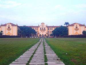
The municipality holds the city for Rural Federal University of Rio de Janeiro (UFRRJ).
Sports
- Annual Student Games
Neighborhoods
- Águas Lindas
- Canto do Rio
- Campo Lindo
- Dom Bosco
- Jardim das Acácias
- Parque Jacimar
- Piranema
- INCRA
- Ecologia
- Fazenda Caxias
- Centro de Seropédica
- Boa Esperança
- Multirão
- Boa Fé
- Santa Sofia
- Jardim Maracanã
- Vera Cruz
- Vila Sônia
- Belvedere
- São Miguel
- Nossa Senhora de Nazaré
References
Capital: Rio de Janeiro | |||||||||||
| Mesoregion Baixadas |
|  | |||||||||
| Mesoregion Centro Fluminense |
| ||||||||||
| Mesoregion Metropolitana do Rio de Janeiro |
| ||||||||||
| Mesoregion Noroeste Fluminense |
| ||||||||||
| Mesoregion Norte Fluminense |
| ||||||||||
| Mesoregion Sul Fluminense |
| ||||||||||
This article is issued from
Wikipedia.
The text is licensed under Creative Commons - Attribution - Sharealike.
Additional terms may apply for the media files.