Saquarema
| Saquarema | |||
|---|---|---|---|
| Municipality | |||
| Município de Saquarema | |||
 Igreja Nossa Senhora de Nazaré | |||
| |||
| Nickname(s): Capital Nacional do Surfing | |||
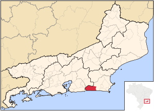 Location of Saquarema in the state of Rio de Janeiro | |||
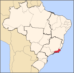
 Saquarema Location of Saquarema in Brazil | |||
| Coordinates: 22°55′12″S 42°30′36″W / 22.92000°S 42.51000°WCoordinates: 22°55′12″S 42°30′36″W / 22.92000°S 42.51000°W | |||
| Country |
| ||
| Region | Southeast | ||
| State |
| ||
| Government | |||
| • Prefeito | Manoela Peres (PTN) | ||
| Area | |||
| • Total | 356.566 km2 (137.671 sq mi) | ||
| Elevation | 2 m (7 ft) | ||
| Population (2010) | |||
| • Total | 83,750 | ||
| Time zone | UTC-3 (UTC-3) | ||
| Website | |||


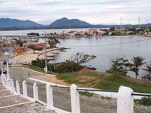
Saquarema (Portuguese pronunciation: [sɐkwɐˈɾẽmɐ]) is a municipality located in the Brazilian state of Rio de Janeiro. Its population is 83,750 (2016) and its area is 353,566 km².[1] It is located almost 73 km east of Rio de Janeiro.[2] It was known as Brazil's surfing capital. It is one of the most beautiful cities in Brazil.
During the mid-19th century, the Conservative Party and its leaders were known as "Saquarema" because of their base of support here.
The Surfing Capital
Saquarema, through its beaches, especially Itaúna Beach, is known as the Brazilian capital of surfing for its perfect waves and indescribable beauty and strength. In the 70's, Saquarema hosted the longing surfing festivals and in 2017, Saquarema becomes part of the world surfing circuit, with WSL.
References
External links
Capital: Rio de Janeiro | |||||||||||
| Mesoregion Baixadas |
|  | |||||||||
| Mesoregion Centro Fluminense |
| ||||||||||
| Mesoregion Metropolitana do Rio de Janeiro |
| ||||||||||
| Mesoregion Noroeste Fluminense |
| ||||||||||
| Mesoregion Norte Fluminense |
| ||||||||||
| Mesoregion Sul Fluminense |
| ||||||||||