Miguel Pereira, Rio de Janeiro
- For the Argentine film director and producer, see Miguel Pereira.
| Miguel Pereira | |||
|---|---|---|---|
| Municipality | |||
| Município de Miguel Pereira | |||
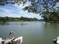 Javary Lake | |||
| |||
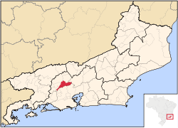 Location of Miguel Pereira in the state of Rio de Janeiro | |||
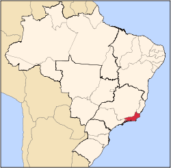
 Miguel Pereira Location of Miguel Pereira in Brazil | |||
| Coordinates: 22°27′14″S 43°28′08″W / 22.45389°S 43.46889°WCoordinates: 22°27′14″S 43°28′08″W / 22.45389°S 43.46889°W | |||
| Country |
| ||
| Region | Southeast | ||
| State |
| ||
| Government | |||
| • Prefeito | André Português (PR) | ||
| Area | |||
| • Total | 287.356 km2 (110.949 sq mi) | ||
| Elevation | 618 m (2,028 ft) | ||
| Population (2010) | |||
| • Total | 24,647 | ||
| Time zone | UTC-3 (UTC-3) | ||
| Website | |||


Miguel Pereira (Portuguese pronunciation: [miˈgɛw peˈɾejɾɐ]) is a municipality located in the Brazilian state of Rio de Janeiro. This city is located in a mountainous area and has gotten the title of climatic health resort. This municipality is known for its climate, rivers, water falls and the cleanliness of the water. Miguel Pereira supplies Baixada Fluminense and a great part of the city of Rio de Janeiro with potable water. Its population was 26,694 (2005) and its area is 287 km².[1]
The city contains part of the Central Rio de Janeiro Atlantic Forest Mosaic of conservation units, created in 2006.[2]
References
- ↑ IBGE - "Archived copy". Archived from the original on 2007-01-09. Retrieved 2007-01-09.
- ↑ Costa, Cláudia; Lamas, Ivana; Fernandes, Rosan (December 2010), Planejamento Estratégico do Mosaico Central Fluminense (PDF) (in Portuguese), Reserva da Biosfera da Mata Atlântica, p. 13, retrieved 2016-10-02
Capital: Rio de Janeiro | |||||||||||
| Mesoregion Baixadas |
|  | |||||||||
| Mesoregion Centro Fluminense |
| ||||||||||
| Mesoregion Metropolitana do Rio de Janeiro |
| ||||||||||
| Mesoregion Noroeste Fluminense |
| ||||||||||
| Mesoregion Norte Fluminense |
| ||||||||||
| Mesoregion Sul Fluminense |
| ||||||||||
This article is issued from
Wikipedia.
The text is licensed under Creative Commons - Attribution - Sharealike.
Additional terms may apply for the media files.