Itaguaí
| Itaguaí | |||
|---|---|---|---|
| Municipality | |||
| Município de Itaguaí | |||
 | |||
| |||
| Nickname(s): Port city | |||
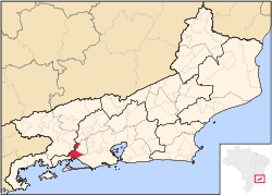 Location of Itaguaí in the state of Rio de Janeiro | |||
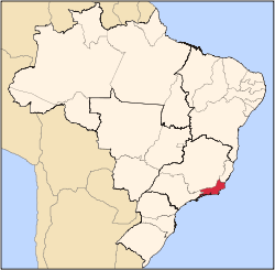
 Itaguaí Location of Itaguaí in Brazil | |||
| Coordinates: 22°51′07″S 43°46′30″W / 22.85194°S 43.77500°WCoordinates: 22°51′07″S 43°46′30″W / 22.85194°S 43.77500°W | |||
| Country |
| ||
| Region | Southeast | ||
| State |
| ||
| Government | |||
| • Prefeito | Carlo Bussatto Júnio (PMDB) | ||
| Area | |||
| • Total | 275.870 km2 (106.514 sq mi) | ||
| Elevation | 15 m (49 ft) | ||
| Population (2010) | |||
| • Total | 109,091 | ||
| Time zone | UTC-3 (UTC-3) | ||
| Website | |||


Itaguaí (Portuguese pronunciation: [itɐgwaˈi]) is a municipality located in the Brazilian state of Rio de Janeiro. Its population was 109.091 in 2014 and its area is 272 km².[1] The city was founded in 1688 and lies midway between Rio de Janeiro and Angra dos Reis.[2]
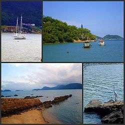
Itaguaí is located approximately 75 km west of the city of Rio de Janeiro on the road to Santos (SP). It is located between the shore of Sepetiba Bay and the Atlantic Rainforest.[3]
Itaguai and the region around it contain some of the largest ore exporting ports in Brazil.[4][5] It also serves also as dormitory town for workers of the industrial western zone (Zona Oeste) of Rio de Janeiro. It is the seat of the Roman Catholic Diocese of Itaguaí.
Port of Itaguai (Sepetiba / Guaiba island)
Itaguai was opened as a deepwater port in 1982, primarily to export alumina and other minerals found in the Minas Gerais region. It includes ports of Itaguai, Sepetiba and Guaiba island.[6][7] The port of Sepetiba is located in the port of Itaguaí.[8] As of August 2018, the port accommodated large bulk carriers (170,000 deadweight).[9] The Port of Sepetiba is further divided into two administrative regions - Sepetiba bay and Sepetiba terminal.[10]
Guaiba island, located close by has separate terminals for exporting mineral ores, but is privately owned by the mining company Vale and comes under the authority of the Port of Itaguai (Rio de Janeiro).[11][12]
References
- ↑ IBGE - "Archived copy". Archived from the original on 2007-01-09. Retrieved 2014-08-03.
- ↑ Sailign Directions - East coast of Brazil (13th ed.). Taunton: UKHO. 1 April 2016.
|access-date=requires|url=(help) - ↑ "Sepetiba tecon - a profile". bnamericas.com. BN Americas. Retrieved 5 September 2018.
- ↑ "Port of Itaguai and Port of Guaiba island". vale.com. Vale. Retrieved 5 September 2018.
- ↑ Guide to port entry. London: World ports guides. 1 January 2018.
|access-date=requires|url=(help) - ↑ "Is iron ore the next copper?" (PDF). cmegroup.com. Platts. Retrieved 5 September 2018.
- ↑ "Official website - Port of Itaguai". portosrio.gov.br (in Portuguese). Ports rio. Retrieved 5 September 2018.
- ↑ "Itaguai port". marinetraffic.com. Marine traffic. Retrieved 5 September 2018.
- ↑ "Still room for Sepetiba in latest box pecking order". Port Strategy. 25 March 2009. Retrieved 5 September 2018.
- ↑ "Sepetiba bay". port-directory.com. Port Directory. Retrieved 5 September 2018.
- ↑ "CSN Receives 10 Offers for Brazil Box Terminal". Marine Link. 8 January 2016. Retrieved 5 September 2018.
- ↑ "Itaguai port pins hopes on extra trans Altantic calls". JOC. Retrieved 5 September 2018.
Capital: Rio de Janeiro | |||||||||||
| Mesoregion Baixadas |
|  | |||||||||
| Mesoregion Centro Fluminense |
| ||||||||||
| Mesoregion Metropolitana do Rio de Janeiro |
| ||||||||||
| Mesoregion Noroeste Fluminense |
| ||||||||||
| Mesoregion Norte Fluminense |
| ||||||||||
| Mesoregion Sul Fluminense |
| ||||||||||