Magarao, Camarines Sur
| Magarao | |
|---|---|
| Municipality | |
| Municipality of Magarao | |
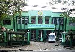 Municipal Hall | |
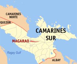 Map of Camarines Sur with Magarao highlighted | |
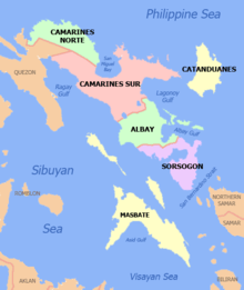
.svg.png) Magarao Location within the Philippines | |
| Coordinates: 13°40′N 123°11′E / 13.67°N 123.18°ECoordinates: 13°40′N 123°11′E / 13.67°N 123.18°E | |
| Country |
|
| Region | Bicol Region (Region V) |
| Province | Camarines Sur |
| District | 2nd district |
| Founded | 1570 |
| Barangays | 15 (see Barangays) |
| Government [1] | |
| • Type | Sangguniang Bayan |
| • Mayor | Philip Salvador A. Señar |
| • Vice Mayor | Randy Villaralbo |
| • Electorate | 16,859 voters (2016) |
| Area [2] | |
| • Total | 44.97 km2 (17.36 sq mi) |
| Population (2015 census)[3] | |
| • Total | 25,694 |
| • Density | 570/km2 (1,500/sq mi) |
| Time zone | UTC+8 (PST) |
| ZIP code | 4403 |
| PSGC | 051720000 |
| IDD : area code | +63 (0)54 |
| Climate type | Tropical rainforest climate |
| Income class | 4th municipal income class |
| Revenue (₱) | 66,397,952.62 (2016) |
| Poverty incidence | 27.83 (2012)[4] |
| Native languages |
Central Bikol Tagalog |
Magarao, officially the Municipality of Magarao, is a 4th class municipality in the province of Camarines Sur, Philippines. According to the 2015 census, it has a population of 25,694 people.[3]
History
Magarao derived its name from a species of thorny wild bush locally known as garao-garao, which abundantly grows in the area. This type of plant no longer exists today as it was believed that the inhabitants of Magarao hindered its growth and propagation because of its thorny appearance.
It was a group of missionaries from the Order of Friars Minor who founded the town in 1570, although missionary work continued only in the year 1690.
Barangays
Magarao is politically subdivided into 15 barangays.
Demographics
| Population census of Magarao | |||||||||||||||||||||||||||||||||||||||||||||||||
|---|---|---|---|---|---|---|---|---|---|---|---|---|---|---|---|---|---|---|---|---|---|---|---|---|---|---|---|---|---|---|---|---|---|---|---|---|---|---|---|---|---|---|---|---|---|---|---|---|---|
|
| ||||||||||||||||||||||||||||||||||||||||||||||||
| Source: Philippine Statistics Authority[3][5][6][7] | |||||||||||||||||||||||||||||||||||||||||||||||||
In the 2015 census, the population of Magarao was 25,694 people,[3] with a density of 570 inhabitants per square kilometre or 1,500 inhabitants per square mile.
Languages
Bicol is widely spoken in the town, while Tagalog, Hiligaynon (Bisaya) and Ilocano are used immigrants and by locals as lingua francas when communicating with non-Bicolanos.
Religion
Residents of Magarao are predominantly Roman Catholic.
Barangay Sta. Lucia holds an annual novena to its patron saint, Lucy of Syracuse, nine days before her feast on 13 December. Villagers bring the saint's image in procession every morning of the novena at the poblacion, a celebration that attracts devotees from other parts of the Bicol Region. Hymns to the saint, known as the Gozos, as well as the Spanish version of the Ave Maria, are chanted during the dawn procession, which is followed by a Mass.
Climate
| Climate data for Magarao, Camarines Sur | |||||||||||||
|---|---|---|---|---|---|---|---|---|---|---|---|---|---|
| Month | Jan | Feb | Mar | Apr | May | Jun | Jul | Aug | Sep | Oct | Nov | Dec | Year |
| Average high °C (°F) | 32 (90) |
31 (88) |
34 (93) |
36 (97) |
37 (99) |
37 (99) |
36 (97) |
34 (93) |
35 (95) |
34 (93) |
33 (91) |
32 (90) |
34 (94) |
| Average low °C (°F) | 27 (81) |
27 (81) |
29 (84) |
31 (88) |
32 (90) |
32 (90) |
31 (88) |
30 (86) |
30 (86) |
29 (84) |
28 (82) |
28 (82) |
30 (85) |
| Average precipitation mm (inches) | 39.34 (1.5488) |
68.7 (2.705) |
26.73 (1.0524) |
66.19 (2.6059) |
84.49 (3.3264) |
178.89 (7.0429) |
244.27 (9.6169) |
188.3 (7.413) |
160.98 (6.3378) |
445 (17.52) |
135.5 (5.335) |
367.8 (14.48) |
2,006.19 (78.9841) |
| Average rainy days | 16 | 18 | 13 | 15 | 23 | 28 | 30 | 24 | 26 | 27 | 25 | 29 | 274 |
| Source: World Weather Online[8] | |||||||||||||
Economy
At present, Magarao belongs to the fifth class municipality although there are improvements being made by the local government to hasten its developmental stage. The town, through the initiative of its local officials, allows its constituents to engage into worthwhile activities by providing for them training and seminar workshops on various livelihood projects like ceramics training, papermaking, handicrafts and other community-based industries.
This was made possible due to the combined efforts made by the local government of Magarao and the provincial government of Camarines Sur through the Provincial Livelihood Training, Research and Development Program. PLTRD is geared towards providing community-based industries, identifying projects for product development and skills training and also conducting seminar and workshops for the various livelihood projects.
The residents of Magarao has immersed themselves in opportunities which would not just serve benefits for them but would obviously boost their town's economic condition.
Transportation
Coastal barangays are served by bancas that ply from the wharf near Naga City to the barangays of Ponong, Barobaybay and Carigsa along the Bicol River and in the estuarine areas.
Utilities
Power and electricity is supplied by the Camarines Sur Electric Cooperative II (CASURECO II).
References
- ↑ "Municipality". Quezon City, Philippines: Department of the Interior and Local Government. Retrieved 31 May 2013.
- ↑ "Province: Camarines Sur". PSGC Interactive. Quezon City, Philippines: Philippine Statistics Authority. Retrieved 12 November 2016.
- 1 2 3 4 Census of Population (2015). "Region V (Bicol Region)". Total Population by Province, City, Municipality and Barangay. PSA. Retrieved 20 June 2016.
- ↑ "PSA Releases the 2012 Municipal and City Level Poverty Estimates". Quezon City, Philippines: Philippine Statistics Authority. Archived from the original on 28 January 2017. Retrieved 28 January 2017.
- ↑ Census of Population and Housing (2010). "Region V (Bicol Region)". Total Population by Province, City, Municipality and Barangay. NSO. Retrieved 29 June 2016.
- ↑ Censuses of Population (1903–2007). "Region V (Bicol Region)". Table 1. Population Enumerated in Various Censuses by Province/Highly Urbanized City: 1903 to 2007. NSO.
- ↑ "Province of Camarines Sur". Municipality Population Data. Local Water Utilities Administration Research Division. Retrieved 17 December 2016.
- ↑ "Magarao, Camarines Sur: Average Temperatures and Rainfall". World Weather Online. Retrieved 29 October 2017.
External links
| Wikimedia Commons has media related to Magarao, Camarines Sur. |
- Philippine Standard Geographic Code
- Philippine Census Information
- Official Site of the Province of Camarines Sur
Pili (capital) | |
| Municipalities | |
| Component city | |
| Independent component city |
|
| Administrative divisions |
|  | ||||
|---|---|---|---|---|---|---|
| Geography | ||||||
| History | ||||||
| Religion | ||||||
| Public utilities and services |
| |||||
| Transportation | ||||||
| Education | ||||||
| Landmarks | ||||||