Del Gallego, Camarines Sur
| Del Gallego | ||
|---|---|---|
| Municipality | ||
| Municipality of Del Gallego | ||
| ||
| Motto(s): Sulong Del Gallego! | ||
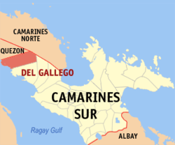 Map of Camarines Sur with Del Gallego highlighted | ||
.svg.png) Del Gallego Location within the Philippines | ||
| Coordinates: 13°55′N 122°36′E / 13.92°N 122.6°ECoordinates: 13°55′N 122°36′E / 13.92°N 122.6°E | ||
| Country |
| |
| Region | Bicol Region (Region V) | |
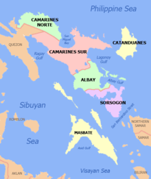
| Province | Camarines Sur | |
| District | 1st district | |
| Founded | 1937 | |
| Barangays | 32 (see Barangays) | |
| Government [1] | ||
| • Type | Sangguniang Bayan | |
| • Mayor | Lydia B. Abarientos | |
| • Vice Mayor | Bayani Veluz | |
| • Electorate | 14,135 voters (2016) | |
| Area [2] | ||
| • Total | 208.31 km2 (80.43 sq mi) | |
| Population (2015 census)[3] | ||
| • Total | 25,397 | |
| • Density | 120/km2 (320/sq mi) | |
| Time zone | UTC+8 (PST) | |
| ZIP code | 4411 | |
| PSGC | 051712000 | |
| IDD : area code | +63 (0)54 | |
| Climate type | Tropical rainforest climate | |
| Income class | 4th municipal income class | |
| Revenue (₱) | 84,068,390.57 (2016) | |
| Poverty incidence | 37.49 (2012)[4] | |
| Native languages |
Central Bikol Tagalog | |
| Website |
www | |

Del Gallego, officially the Municipality of Del Gallego, is a 4th class municipality in the province of Camarines Sur, Philippines. According to the 2015 census, it has a population of 25,397 people.[3]
It used to be called Danawin and is located along Kilbay River. It was established through Executive Order No. 56 Series of 1936 signed by then President Manuel L. Quezon.
The municipality celebrated its 80th foundation anniversary on October 5, 2017.
Del Gallego is the last town in the northern part of Camarines Sur. This is where the Quirino Highway (Andaya Highway) road meets with the first town of Quezon province, Tagkawayan.
According to the town's socio-economic profile in the year 1998, agricultural workers are greater in number reaching about 70% of the whole working force while the remaining 30% are engaged in non-agricultural occupations.
History
In 1959, the following sitios were converted into barrios: Sinuknipan, Sabang, Pasay and Bajo (renamed to San Juan).[5]
Barangays
Del Gallego is politically subdivided into 32 barangays.
- Bagong Silang
- Bucal
- Cabasag
- Comadaycaday
- Domagondong
- Kinalangan
- Comadogcadog
- Mabini
- Magais I
- Magais II
- Mansalaya
- Nagkalit
- Palaspas
- Pamplona
- Pasay
- Pinagdapian
- Pinugusan
- Zone I Fatima (Poblacion)
- Zone II San Antonio (Poblacion)
- Poblacion Zone III
- Sabang
- Salvacion
- San Juan
- San Pablo
- Santa Rita I
- Santa Rita II
- Peñafrancia (Sinagawsawan)
- Sinuknipan I
- Sinuknipan II
- Sugsugin
- Tabion
- Tomagoktok
Demographics
| Population census of Del Gallego | ||
|---|---|---|
| Year | Pop. | ±% p.a. |
| 1939 | 4,883 | — |
| 1948 | 9,915 | +8.19% |
| 1960 | 11,820 | +1.48% |
| 1970 | 12,664 | +0.69% |
| 1975 | 13,754 | +1.67% |
| 1980 | 13,476 | −0.41% |
| 1990 | 17,047 | +2.38% |
| 1995 | 18,760 | +1.81% |
| 2000 | 20,456 | +1.87% |
| 2007 | 21,272 | +0.54% |
| 2010 | 23,064 | +2.99% |
| 2015 | 25,397 | +1.85% |
| Source: Philippine Statistics Authority[3] [6] [7] [8] | ||
In the 2015 census, the population of Del Gallego was 25,397 people,[3] with a density of 120 inhabitants per square kilometre or 310 inhabitants per square mile.
Climate
| Climate data for Del Gallego, Camarines Sur | |||||||||||||
|---|---|---|---|---|---|---|---|---|---|---|---|---|---|
| Month | Jan | Feb | Mar | Apr | May | Jun | Jul | Aug | Sep | Oct | Nov | Dec | Year |
| Average high °C (°F) | 32 (90) |
31 (88) |
35 (95) |
37 (99) |
37 (99) |
35 (95) |
34 (93) |
34 (93) |
34 (93) |
33 (91) |
32 (90) |
31 (88) |
34 (93) |
| Average low °C (°F) | 26 (79) |
26 (79) |
28 (82) |
30 (86) |
31 (88) |
30 (86) |
29 (84) |
29 (84) |
29 (84) |
29 (84) |
28 (82) |
27 (81) |
29 (83) |
| Average precipitation mm (inches) | 104.02 (4.0953) |
52.53 (2.0681) |
60.67 (2.3886) |
95.79 (3.7713) |
337.51 (13.2878) |
344.38 (13.5583) |
258.12 (10.1622) |
169.08 (6.6567) |
242.35 (9.5413) |
268.86 (10.585) |
113.40 (4.4646) |
303.9 (11.965) |
2,350.61 (92.5442) |
| Average rainy days | 24 | 24 | 23 | 24 | 26 | 30 | 31 | 28 | 28 | 28 | 28 | 30 | 324 |
| Source: World Weather Online[9] | |||||||||||||
Education
Public and private schools:
- Del Gallego Central School
- Alfelor Sr. Memorial College
- Magais Elementary School
- Del Gallego High School
- Mansalaya National High School
- Sinuknipan National High School
- Colegio de Sta. Rita Foundation, Inc.
References
- ↑ "Municipality". Quezon City, Philippines: Department of the Interior and Local Government. Retrieved 31 May 2013.
- ↑ "Province: Camarines Sur". PSGC Interactive. Quezon City, Philippines: Philippine Statistics Authority. Retrieved 12 November 2016.
- 1 2 3 4 Census of Population (2015). "Region V (Bicol Region)". Total Population by Province, City, Municipality and Barangay. PSA. Retrieved 20 June 2016.
- ↑ "PSA Releases the 2012 Municipal and City Level Poverty Estimates". Quezon City, Philippines: Philippine Statistics Authority. Archived from the original on 28 January 2017. Retrieved 28 January 2017.
- ↑ "R.A. No. 2108, An Act Creating Certain Barrios in the Municipality of Del Gallego, Province of Camarines Sur". LawPH.com. Archived from the original on 2012-07-10. Retrieved 2011-04-13.
- ↑ Census of Population and Housing (2010). "Region V (Bicol Region)". Total Population by Province, City, Municipality and Barangay. NSO. Retrieved 29 June 2016.
- ↑ Censuses of Population (1903–2007). "Region V (Bicol Region)". Table 1. Population Enumerated in Various Censuses by Province/Highly Urbanized City: 1903 to 2007. NSO.
- ↑ "Province of Camarines Sur". Municipality Population Data. Local Water Utilities Administration Research Division. Retrieved 17 December 2016.
- ↑ "Del Gallego, Camarines Sur: Average Temperatures and Rainfall". World Weather Online. Retrieved 29 October 2017.
External links
- Philippine Standard Geographic Code
- Philippine Census Information
- Official Site of the Province of Camarines Sur
Places adjacent to Del Gallego, Camarines Sur | |
|---|---|
Pili (capital) | |
| Municipalities | |
| Component city | |
| Independent component city |
|